
Fájl:Crookston Commercial Historic District.jpg

Eredeti fájl (956 × 757 képpont, fájlméret: 84 KB, MIME-típus: image/jpeg)
|
Ez a fájl a Wikimedia Commonsból származik. Az alább látható leírás az ottani dokumentációjának másolata. A Commons projekt szabad licencű kép- és multimédiatár. Segíts te is az építésében! |
|
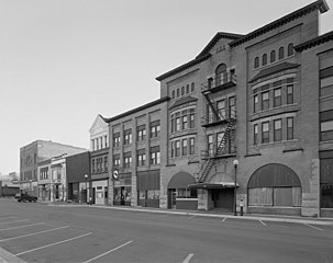
This is an image of a place or building that is listed on the National Register of Historic Places in the United States of America. Its reference number is 84002709. |
| Leírás |
English: Buildings in the Crookston Commercial Historic District in central Crookston, Polk County, Minnesota, United States. The district reflects the city's early period of growth, which was prompted by agriculture and the railroad industry. It remains a large, and mostly intact, concentration of late nineteenth- and early twentieth-century commercial structures and is listed on the National Register of Historic Places. |
|||||
| Dátum | Ismeretlen dátum | |||||
| Forrás | Library of Congress Prints and Photographs Division, Historic American Buildings Survey: MINN,60-CROK,1-6 | |||||
| Szerző | Anonim | |||||
| Engedély (Fájl újrafelhasználása) |
|

| Objektum elhelyezkedése | | További képek erről a helyről: OpenStreetMap |
|---|

|
Ez a image az Egyesült Államok Kongresszusi Könyvtárának Nyomdai és Fotográfiai Osztályától származik az alábbi azonosítóval: hhh.mn0444.
Ez a sablon nem a licenc jelölésére szolgál. Szükség van egy licencsablonra is. Lásd a Commons:Licencelés lapot.
|
Fájltörténet
Kattints egy időpontra, hogy a fájl akkori állapotát láthasd.
| Dátum/idő | Bélyegkép | Felbontás | Feltöltő | Megjegyzés | |
|---|---|---|---|---|---|
| aktuális | 2009. január 31., 16:07 | | 956 × 757 (84 KB) | Cropbot | upload cropped version, operated by User:Finavon. Summary: border cropped |
| 2009. január 29., 16:35 |  | 1 024 × 818 (96 KB) | Nyttend | {{Information |Description=Photograph from the {{w|Historic American Buildings Survey}} of buildings in the {{w|Crookston Commercial Historic District}}, an area listed on the {{w|National Register of Historic Places}}. The district is located in central |
Fájlhasználat
Az alábbi lap használja ezt a fájlt:
Globális fájlhasználat
A következő wikik használják ezt a fájlt:
- Használata itt: ar.wikipedia.org
- Használata itt: arz.wikipedia.org
- Használata itt: azb.wikipedia.org
- Használata itt: be.wikipedia.org
- Használata itt: ca.wikipedia.org
- Használata itt: ceb.wikipedia.org
- Használata itt: ce.wikipedia.org
- Használata itt: dag.wikipedia.org
- Használata itt: de.wikipedia.org
- Használata itt: en.wikipedia.org
- Használata itt: en.wikivoyage.org
- Használata itt: es.wikipedia.org
- Használata itt: eu.wikipedia.org
- Használata itt: fa.wikipedia.org
- Használata itt: fr.wikipedia.org
- Használata itt: ht.wikipedia.org
- Használata itt: ia.wikipedia.org
- Használata itt: ko.wikipedia.org
- Használata itt: lld.wikipedia.org
- Használata itt: pt.wikipedia.org
- Használata itt: ru.wikipedia.org
- Használata itt: sh.wikipedia.org
- Használata itt: sr.wikipedia.org
- Használata itt: tr.wikipedia.org
- Használata itt: tt.wikipedia.org
- Használata itt: uk.wikipedia.org
- Használata itt: ur.wikipedia.org
- Használata itt: uz.wikipedia.org
- Használata itt: vi.wikipedia.org
- Használata itt: www.wikidata.org
- Használata itt: zh-min-nan.wikipedia.org