
Fájl:Cold War alliances mid-1975.svg

Ennek a(z) SVG fájlnak ezen PNG formátumú előnézete: 800 × 409 képpont. További felbontások: 320 × 164 képpont | 640 × 327 képpont | 1 024 × 524 képpont | 1 280 × 655 képpont | 2 560 × 1 310 képpont | 860 × 440 képpont.
Eredeti fájl (SVG fájl, névlegesen 860 × 440 képpont, fájlméret: 1,36 MB)
|
Ez a fájl a Wikimedia Commonsból származik. Az alább látható leírás az ottani dokumentációjának másolata. A Commons projekt szabad licencű kép- és multimédiatár. Segíts te is az építésében! |
Összefoglaló
| Leírás |
Dansk: Et simplificeret kort over den Kolde Krigs alliancer, som de så ud mellem 30. april og 24. juni 1975. De sovjetiske og kinesiske blokke er gruppet sammen af illustrative årsager, men under den repræsenterede tidsperiode var de ikke allierede. Den grå region udgjorde ikke en alliance, men indeholder derimod alle de lande, der ikke var allierede med Sovjetunionen, USA, eller Kina. Dette kort er baseret på File:First second third worlds map.svg, men er ændret til at vise en gruppering af lande der kan bekræftes og præcist afspejler titen af GFS [1].
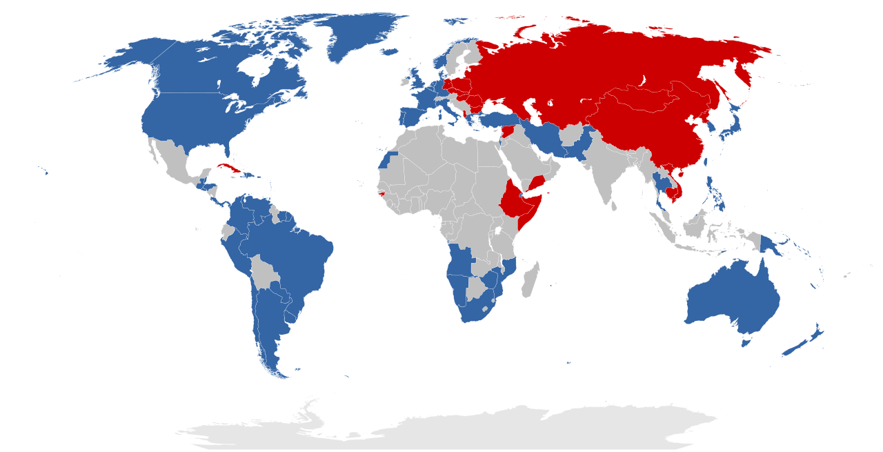
English: A simplified map of the Cold War alliances between 30 April and 24 June 1975. The Soviet and Chinese blocs are grouped together as one for illustrative purposes, but note that historically they were not allied during the time represented. The grey region does not represent an alliance, but rather encompasses all countries that were not aligned with the Soviet Union, the USA, or China. This map is based on File:First second third worlds map.svg, but it is modified to display a grouping of countries that is verifiable and accurately reflects the caption of Three Worlds.
Rationale:
Eastern-aligned:
Nederlands: Een vereenvoudigde kaart van de bondgenootschappen tussen 30 april en 24 juni 1975. De Sovjet en Chinese blokken zijn gegroepeerd voor illustratieve doeleinden, maar merk op dat, historisch gezien, ze geen bondgenootschap hadden in die tijdsperiode. De grijs regio stelt geen bondgenootschap voor, maar voegt eerder alle landen samen die geen banden hadden met de Sovjet-Unie, de VS of China. Deze kaart is gebaseerd op File:First second third worlds map.svg, maar ze is aangepast om de landen weer te geven die tot de Eerste, Tweede of Derde Wereld behoren [2]. |
| Dátum | |
| Forrás | A feltöltő saját munkája |
| Szerző | Vorziblix |
Licenc
Én, e mű szerzője a művemet az alábbi licenc alatt teszem közzé:
| Ez a fájl a Creative Commons CC0 1.0 Universal Public Domain Dedication licenc alatt lett közzétéve. | |
| A műhöz tartozó személy ezzel a dokumentummal a munkáját köztulajdonná tette. A törvények alapján megengedhető mértékig lemondott minden őt megillető jogról a szerzői jog és az összes kapcsolódó vagy vonatkozó törvény alapján, ami a munka alapján neki járna az egész világon. A CC0 alatt kiadott művek szerzőjét nem kell megjelölni. A munka hivatkozásakor nem kell jóváhagyást kérni a szerzőtől.
|
Fájltörténet
Kattints egy időpontra, hogy a fájl akkori állapotát láthasd.
| Dátum/idő | Bélyegkép | Felbontás | Feltöltő | Megjegyzés | |
|---|---|---|---|---|---|
| aktuális | 2023. december 1., 20:53 | | 860 × 440 (1,36 MB) | Human Transistor | Guinea-Bissau and Cambodia were colored red. They were Communist states at this time. |
| 2023. június 5., 21:07 |  | 860 × 440 (1,36 MB) | Ajhuheu | Reverted to version as of 20:57, 22 April 2023 (UTC) | |
| 2023. június 5., 13:29 |  | 860 × 440 (1 MB) | YourGloriousLeader | Optimized 60% of previous | |
| 2023. április 22., 22:57 |  | 860 × 440 (1,36 MB) | Discombobulates | Remove unnecessary strokes | |
| 2023. április 22., 16:11 |  | 860 × 440 (1,36 MB) | Discombobulates | Consistency: mid-1975 is 1 June, Cabo Verde, Comoros, and São Tomé were all still colonies | |
| 2023. április 2., 10:22 |  | 860 × 440 (1,36 MB) | Discombobulates | Cyprus isn't (/wasn't) in NATO, the UK would only (have) defend(ed) their bases | |
| 2023. március 11., 20:36 |  | 860 × 440 (1,36 MB) | Discombobulates | Reverted to version as of 05:47, 9 March 2023 (UTC), please see talk page and follow WP:Consensus | |
| 2023. március 11., 13:26 |  | 860 × 440 (1,36 MB) | FanofMultimedia123 | Describing non-aligned states with green is better than leaving them grey | |
| 2023. március 9., 07:47 |  | 860 × 440 (1,36 MB) | Discombobulates | Fix the colour of all neutral countries | |
| 2023. március 8., 20:39 |  | 860 × 440 (1,36 MB) | Discombobulates | Fix the colour of some neutral countries, colour Cyprus blue again due to the prescene of UK bases |
Fájlhasználat
Az alábbi lap használja ezt a fájlt:
Globális fájlhasználat
A következő wikik használják ezt a fájlt:
- Használata itt: ar.wikipedia.org
- Használata itt: ary.wikipedia.org
- Használata itt: blk.wikipedia.org
- Használata itt: bn.wikipedia.org
- Használata itt: ca.wikipedia.org
- Használata itt: cs.wikipedia.org
- Használata itt: cy.wikipedia.org
- Használata itt: de.wikipedia.org
- Használata itt: el.wikipedia.org
- Használata itt: en.wikipedia.org
- Third World
- Developing country
- Eastern Bloc
- World war
- First World
- Second World
- Cold War
- Détente
- Western Bloc
- Polarity (international relations)
- Third-worldism
- Template:Three worlds
- Western world
- Portal:Society/Featured article
- Portal:Society/Featured article/38
- Three-world model
- User:Eldryn T/sandbox
- User:Falcaorib/World Alliances
- Használata itt: en.wiktionary.org
- Használata itt: eo.wikipedia.org
A fájl globális használatának megtekintése