
Fájl:British Isles.svg

Ennek a(z) SVG fájlnak ezen PNG formátumú előnézete: 361 × 600 képpont. További felbontások: 144 × 240 képpont | 289 × 480 képpont | 462 × 768 képpont | 616 × 1 024 képpont | 1 232 × 2 048 képpont | 1 300 × 2 160 képpont.
Eredeti fájl (SVG fájl, névlegesen 1 300 × 2 160 képpont, fájlméret: 154 KB)
|
Ez a fájl a Wikimedia Commonsból származik. Az alább látható leírás az ottani dokumentációjának másolata. A Commons projekt szabad licencű kép- és multimédiatár. Segíts te is az építésében! |
Összefoglaló
| Leírás |
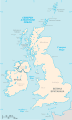
An SVG map of the British Isles, with the largest islands and archipelagos labelled. Always considered part of the British Isles
Sometimes considered part of the British Isles
Other lands |
| Forrás | A feltöltő saját munkája |
| Szerző | Smurrayinchester |
| SVG kód | Ezen SVG kép forráskódja érvénytelen. Ez vektorgrafikus kép Other tools segítségével készült This map is translated using SVG switch elements: all translations are stored in the same file. |
}
Licenc
Én, e mű szerzője a művemet az alábbi licenc alatt teszem közzé:

|
Ez a fájl szabadon másolható, terjeszthető és/vagy módosítható a GNU Szabad Dokumentációs Licenc feltételei alapján, az 1.2 vagy későbbi, a Free Software Foundation által publikált Nem Változtatható szakaszok, Címlapszövegek és Hátlapszövegek nélküli változat szerint. E licenc egy példánya a GNU Szabad Dokumentációs Licenc című fejezetben olvasható. |
| Ez a fájl a Creative Commons Nevezd meg! – Így add tovább! 3.0 Unported licenc alapján használható fel. | ||
| ||
| Ez a licenc a GFDL licenccsere során került a fájlra. |
Derivative works
-
 македонски
 -
 Flag map (1801–1922)


derivative works
Származékos művek: British Isles mk.svg
Fájltörténet
Kattints egy időpontra, hogy a fájl akkori állapotát láthasd.
| Dátum/idő | Bélyegkép | Felbontás | Feltöltő | Megjegyzés | |
|---|---|---|---|---|---|
| aktuális | 2019. február 10., 17:33 | | 1 300 × 2 160 (154 KB) | MSG17 | Uploaded from SVG Translate. |
| 2018. október 13., 16:56 |  | 1 300 × 2 160 (141 KB) | Seb35 | small bug: translations have to be before the default text else the PNG rendering selects the default text | |
| 2018. október 13., 16:51 |  | 1 300 × 2 160 (141 KB) | Seb35 | added French translation | |
| 2014. május 20., 16:50 |  | 1 300 × 2 160 (135 KB) | NikNaks | More cleaning. File could still be a lot smaller than it currently is | |
| 2014. május 20., 05:02 |  | 1 300 × 2 160 (152 KB) | NikNaks | Malay translation | |
| 2014. május 20., 04:36 |  | 1 300 × 2 160 (148 KB) | NikNaks | Cleaning unfortunately lost detail. Will have to return to later | |
| 2014. május 20., 04:22 |  | 1 297 × 2 160 (37 KB) | NikNaks | Attempting to clean up the file before translation | |
| 2006. augusztus 20., 14:37 |  | 1 297 × 2 160 (196 KB) | Smurrayinchester | An SVG map of the British Isles, with the largest islands and archipelagos labeled. {{legend|#fff0de|Always considered part of the British Isles|border=#ffffff}} {{legend|#ffb380|Sometimes considered part of the British Isles|border=#ffffff}} {{legend|#e |
Fájlhasználat
Ezt a fájlt nem használja egyetlen lap sem.
Globális fájlhasználat
A következő wikik használják ezt a fájlt:
- Használata itt: ar.wikipedia.org
- Használata itt: az.wikipedia.org
- Használata itt: be.wikipedia.org
- Használata itt: bs.wikipedia.org
- Használata itt: ceb.wikipedia.org
- Használata itt: ckb.wikipedia.org
- Használata itt: da.wikipedia.org
- Használata itt: en.wikipedia.org
- Geography of the Isle of Man
- Burhou
- Talk:International Football Association Board
- Module:Location map/data/British Isles/doc
- List of offshore wind farms in the Irish Sea
- Siege of St Andrews Castle
- User:Malpass93/sandbox
- Module:Location map/data/British Isles
- 2014 Senior Open Championship
- 2017 Senior Open Championship
- 2018 Eisenhower Trophy
- User:Grover cleveland/History of the laws of the game/List of IFAB meetings
- User:Grover cleveland/English managers
- 2018 Espirito Santo Trophy
- 1965 European Amateur Team Championship
- 1975 European Amateur Team Championship
- 1981 European Amateur Team Championship
- 1989 European Amateur Team Championship
- 1997 European Amateur Team Championship
- 2005 European Amateur Team Championship
- 2007 European Amateur Team Championship
- 2009 European Amateur Team Championship
- 1971 European Ladies' Team Championship
- 1979 European Ladies' Team Championship
- 1987 European Ladies' Team Championship
- 1991 European Ladies' Team Championship
- 2013 European Ladies' Team Championship
- 2021 European Ladies' Team Championship
- 2022 European Amateur Team Championship
- 2022 European Ladies' Team Championship
- 2013 Senior Open Championship
- 2012 Senior Open Championship
- 2011 Senior Open Championship
- 2008 Senior Open Championship
- 2006 Senior Open Championship
- 2002 Senior British Open
- 2001 Senior British Open
- 2000 Senior British Open
- 2022 Senior Open Championship
- User:Erik Sergeant/sandbox 2
- 2023 Senior Open Championship
- Module:Location map/data/British Isles/sandbox
- Draft:2024 Monoposto Championship
A fájl globális használatának megtekintése