
Fájl:Bosnie et Sandjak 1904.svg

Ennek a(z) SVG fájlnak ezen PNG formátumú előnézete: 657 × 600 képpont. További felbontások: 263 × 240 képpont | 526 × 480 képpont | 841 × 768 képpont | 1 122 × 1 024 képpont | 2 243 × 2 048 képpont | 2 000 × 1 826 képpont.
Eredeti fájl (SVG fájl, névlegesen 2 000 × 1 826 képpont, fájlméret: 139 KB)
|
Ez a fájl a Wikimedia Commonsból származik. Az alább látható leírás az ottani dokumentációjának másolata. A Commons projekt szabad licencű kép- és multimédiatár. Segíts te is az építésében! |
Összefoglaló
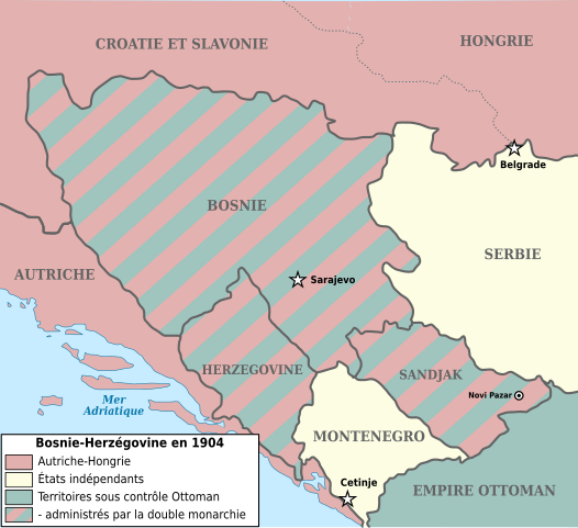
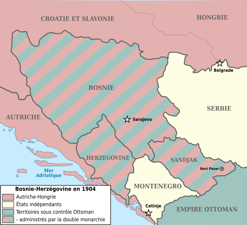
| Leírás | Map showing Bosnia-Herzegovina and the Sanjak of Novibazar (1904). |
| Dátum | (UTC) |
| Forrás | |
| Szerző |
|
| Más változatok |
Származékos művek: |
| Ez egy retusált kép, ami azt jelenti, hogy az eredetihez képest digitálisan módosították. Módosítások: '. Az eredeti itt található: Bosnia-Herzegovina and Sanjak of Novibazar.JPG.
|

|
Ez a fájl szabadon másolható, terjeszthető és/vagy módosítható a GNU Szabad Dokumentációs Licenc feltételei alapján, az 1.2 vagy későbbi, a Free Software Foundation által publikált Nem Változtatható szakaszok, Címlapszövegek és Hátlapszövegek nélküli változat szerint. E licenc egy példánya a GNU Szabad Dokumentációs Licenc című fejezetben olvasható. |
| Ez a fájl a Creative Commons Nevezd meg! – Így add tovább! 3.0 Unported licenc alapján használható fel. | ||
| ||
| Ez a licenc a GFDL licenccsere során került a fájlra. |
Eredeti feltöltési napló
This image is a derivative work of the following images:
- Image:Bosnia-Herzegovina_and_Sanjak_of_Novibazar.JPG licensed with PD-US
- 2008-07-29T10:34:31Z Rcbutcher 5696x5200 (17763428 Bytes) {{Information |Description=Map showing Bosnia-Herzegovina and the Sanjak of Novibazar. |Source=The Century Dictionary and Cyclopedia, Vol X, Map No. 89, Copyright 1897 and 1902; Cyclopedia itself, Copyright 1889, 1890, 1891..
Uploaded with derivativeFX
Fájltörténet
Kattints egy időpontra, hogy a fájl akkori állapotát láthasd.
| Dátum/idő | Bélyegkép | Felbontás | Feltöltő | Megjegyzés | |
|---|---|---|---|---|---|
| aktuális | 2018. január 1., 18:34 | | 2 000 × 1 826 (139 KB) | Flappiefh | Police DejaVu uniformisée, frontières inter-états plus marquées, changement du titre en légende. |
| 2017. december 30., 17:25 |  | 2 000 × 1 826 (129 KB) | Flappiefh | Modification apportées à la demande du Conteur (https://fr.wikipedia.org/wiki/Utilisateur:Conteur-momentanement-indisponible) via l'Atelier Cartes. Au programme : légende refaite, frontières en gris, Dalmatie remplacée par Autriche, une frontière... | |
| 2013. május 2., 22:39 |  | 2 000 × 1 826 (82 KB) | Fulvio314 | Removed black artifact (Inkscape issue) | |
| 2012. december 29., 16:31 |  | 2 000 × 1 826 (108 KB) | Ciaurlec | Moved Dynamic text to simple text | |
| 2009. május 30., 10:03 |  | 2 000 × 1 826 (109 KB) | Le serbe | (ajoute légende des états "avant blanc"(Serbie, Monténégro) La Hongrie n'est pas l'Autriche-Hongrie mais juste la Hongrie. L'Albanie et la Macédoine ne sont pas, la Turquie. La Turquie n'existe pas à l'époque, on parle d'empire ottoman. ) | |
| 2009. május 30., 10:02 |  | 2 000 × 1 826 (109 KB) | Le serbe | ajoute légende des états "avant blanc"(Serbie, Monténégro) La Hongrie n'est pas l'Autriche-Hongrie mais juste la Hongrie. L'Albanie et la Macédoine ne sont pas, la Turquie. La Turquie n'existe pas à l'époque, on parle d'empire ottoman. | |
| 2008. szeptember 16., 13:59 |  | 2 000 × 1 826 (163 KB) | Tinodela | {{Information |Description= |Source= |Date= |Author= |Permission= |other_versions= }} | |
| 2008. szeptember 16., 13:58 |  | 2 000 × 1 826 (87 KB) | Tinodela | {{Information |Description=Map showing Bosnia-Herzegovina and the Sanjak of Novibazar (1904). |Source=*Image:Bosnia-Herzegovina_and_Sanjak_of_Novibazar.JPG |Date=2008-09-16 11:57 (UTC) |Author=*derivative work: ~~~ *[[:Image:Bosnia-Herzegovina_and_S |
Fájlhasználat
Ezt a fájlt nem használja egyetlen lap sem.
Globális fájlhasználat
A következő wikik használják ezt a fájlt:
- Használata itt: el.wikipedia.org
- Használata itt: en.wikipedia.org
- Használata itt: fi.wikipedia.org
- Használata itt: fr.wikipedia.org