
Fájl:Aldwych in 1900 (station location).png
Aldwych_in_1900_(station_location).png (409 × 295 képpont, fájlméret: 284 KB, MIME-típus: image/png)
|
Ez a fájl a Wikimedia Commonsból származik. Az alább látható leírás az ottani dokumentációjának másolata. A Commons projekt szabad licencű kép- és multimédiatár. Segíts te is az építésében! |
.png)
| Leírás |
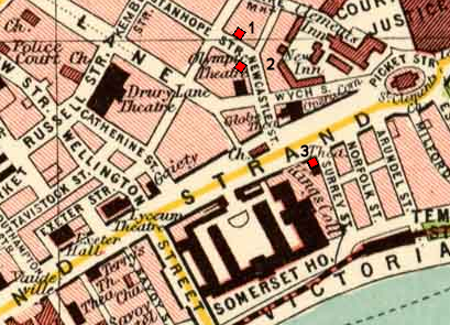
Map of Aldwych area of London circa 1900, annotated with the planned and final locations of Aldwych underground station: |
| Dátum | |
| Forrás |
Map taken from Plate 7 of "The Pocket Atlas & Guide to London" by John Bartholomew and Son. |
| Szerző | Base map by unknown artist, published by John Bartholomew and Son circa 1900. |
| Engedély (Fájl újrafelhasználása) |
see below |
- A következőket teheted a művel:
- megoszthatod – szabadon másolhatod, terjesztheted, bemutathatod és előadhatod a művet
- feldolgozhatod – származékos műveket hozhatsz létre
- Az alábbi feltételekkel:
- Nevezd meg! – A szerzőt megfelelően fel kell tüntetned, hivatkozást kell létrehoznod a licencre és jelezned kell, ha a művön változtatást hajtottál végre. Ezt bármilyen észszerű módon megteheted, kivéve oly módon, ami azt sugallná hogy a jogosult támogat téged vagy a felhasználásod körülményeit.
Fájltörténet
Kattints egy időpontra, hogy a fájl akkori állapotát láthasd.
| Dátum/idő | Bélyegkép | Felbontás | Feltöltő | Megjegyzés | |
|---|---|---|---|---|---|
| aktuális | 2011. július 26., 17:38 | | 409 × 295 (284 KB) | McGeddon~commonswiki | scratch that - this loses the precise locations at the expense of thumbnail clarity, so probably isn't worth it |
| 2011. július 26., 17:35 |  | 409 × 295 (299 KB) | McGeddon~commonswiki | Indicating the three sites more prominently. | |
| 2010. július 23., 00:07 |  | 409 × 295 (284 KB) | DavidCane | smaller version | |
| 2010. július 23., 00:01 |  | 684 × 524 (785 KB) | DavidCane | {{Information |Description=Map of Aldwych area of London circa 1900, annotated with the planned and final locations of Aldwych underground station:<br> 1. Planned location; corner of Stanhope & Holles Street (not s |
Fájlhasználat
Az alábbi lap használja ezt a fájlt:
Globális fájlhasználat
A következő wikik használják ezt a fájlt:
- Használata itt: de.wikipedia.org
- Használata itt: en.wikipedia.org
- Használata itt: it.wikipedia.org
- Használata itt: nl.wikipedia.org
- Használata itt: zh.wikipedia.org
.png)