
Fájl:Abbasid Caliphate most extant.png
Nem érhető el nagyobb felbontású változat.
Abbasid_Caliphate_most_extant.png (800 × 487 képpont, fájlméret: 85 KB, MIME-típus: image/png)
|
Ez a fájl a Wikimedia Commonsból származik. Az alább látható leírás az ottani dokumentációjának másolata. A Commons projekt szabad licencű kép- és multimédiatár. Segíts te is az építésében! |
| Leírás |
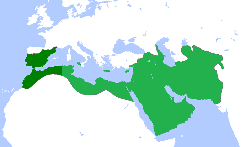
English: Locator map for the Abbasid Caliphate at its greatest extent, before the independence of al-Maghrib (Morocco and parts of Algeria) in 744 as well as al-Andalus (Spain and Portugal) in 756 |
| Dátum | (UTC) |
| Forrás | |
| Szerző |
|
| Ez egy retusált kép, ami azt jelenti, hogy az eredetihez képest digitálisan módosították. Módosítások: seperated the parts that gained independance from the Abbasid Caliphate. Az eredeti itt található: Umayyad750ADloc.png. Módosította: Bassem.
|
Én, e mű szerzője a művemet az alábbi licenc alatt teszem közzé:
Ez a fájl a Creative Commons Nevezd meg! 3.0 Unported licenc alapján használható fel.
- A következőket teheted a művel:
- megoszthatod – szabadon másolhatod, terjesztheted, bemutathatod és előadhatod a művet
- feldolgozhatod – származékos műveket hozhatsz létre
- Az alábbi feltételekkel:
- Nevezd meg! – A szerzőt megfelelően fel kell tüntetned, hivatkozást kell létrehoznod a licencre és jelezned kell, ha a művön változtatást hajtottál végre. Ezt bármilyen észszerű módon megteheted, kivéve oly módon, ami azt sugallná hogy a jogosult támogat téged vagy a felhasználásod körülményeit.
Eredeti feltöltési napló
This image is a derivative work of the following images:
- File:Umayyad750ADloc.png licensed with Cc-by-3.0
- 2009-04-22T16:17:51Z Gabagool 1481x902 (51495 Bytes) some corrections..
- 2009-04-20T16:10:54Z Gabagool 1481x902 (51573 Bytes) {{Information |Description={{en|1=Locator map for the Umayyad Caliphate at its greatest extent, c. AD 750. (Partially based on ''Atlas of World History'' (2007) - World 500-750, map.)}} |Source=Own work by uploader |Author=[
Uploaded with derivativeFX
Fájltörténet
Kattints egy időpontra, hogy a fájl akkori állapotát láthasd.
| Dátum/idő | Bélyegkép | Felbontás | Feltöltő | Megjegyzés | |
|---|---|---|---|---|---|
| aktuális | 2013. április 13., 20:50 | | 800 × 487 (85 KB) | Fry1989 | vandalism |
| 2013. április 13., 18:01 |  | 800 × 487 (87 KB) | Mouh2jijel | Reverted to version as of 08:30, 13 April 2013 | |
| 2013. április 13., 16:32 |  | 800 × 487 (85 KB) | Omar-toons | Reverted to version as of 23:40, 15 November 2012 rv unjustified revert | |
| 2013. április 13., 10:30 |  | 800 × 487 (87 KB) | Mouh2jijel | Reverted to version as of 18:50, 8 April 2013 | |
| 2013. április 13., 08:18 |  | 800 × 487 (85 KB) | Omar-toons | Reverted to version as of 23:40, 15 November 2012 unjustified revert | |
| 2013. április 8., 20:50 |  | 800 × 487 (87 KB) | Mouh2jijel | Reverted to version as of 17:29, 24 April 2012 | |
| 2012. november 16., 01:40 |  | 800 × 487 (85 KB) | Omar-toons | moving southern Ifriqiyan limits a little bit to the north | |
| 2012. április 24., 19:29 |  | 800 × 487 (87 KB) | Cplakidas | corrections: Sardinia and Corsica were never taken, and Sicily was not completely conquered until the 870s | |
| 2011. április 25., 21:11 |  | 800 × 487 (87 KB) | باسم | added a few Mediterranean islands | |
| 2011. április 25., 20:12 |  | 800 × 487 (87 KB) | باسم | {{Information |Description={{en|1=Locator map for the Abbasid Caliphate at its greatest extent, before the independence of al maghrib (morocco and parts of algeria) as well as al andalus (Spain and Portugal)}} |Source=*File:Umayyad750ADloc.png |Date |
Fájlhasználat
Ezt a fájlt nem használja egyetlen lap sem.
Globális fájlhasználat
A következő wikik használják ezt a fájlt:
- Használata itt: ar.wikipedia.org
- العراق
- بغداد
- تاريخ العراق
- البصرة
- تاريخ إسلامي
- خلافة إسلامية
- الدولة العباسية
- غامد
- برامكة
- قائمة الخلفاء
- بوابة:الإسلام/مقالة مختارة
- تاريخ اليمن الإسلامي
- بوابة:الإمبراطورية الروسية
- بوابة:الإمبراطورية الروسية/بوابات شقيقة
- ويكيبيديا:مقالة الصفحة الرئيسية المختارة/152
- خالد بن برمك
- الممالك في إفريقيا قبل الاستعمار
- يحيى البرمكي
- بوابة:مكة/مقالة مختارة/أرشيف
- بوابة:مكة/مقالة مختارة/10
- بوابة:الأديان/تاريخ ديني
- بوابة:الإسلام/دولة مختارة
- بوابة:الإسلام/دولة مختارة/3
- بوابة:العراق/مقالة مختارة/أرشيف
- بوابة:العراق/مقالة مختارة/2
- بوابة:التاريخ الإسلامي/مقالة مختارة/أرشيف
- مستخدم:باحث
- بوابة:التاريخ/فقرات منوعة/3
- بوابة:التاريخ/فقرات منوعة/أرشيف
- بوابة:التاريخ الإسلامي/دولة مختارة/أرشيف
- بوابة:الإمبراطورية الألمانية
- بوابة:الإمبراطورية الألمانية/بوابات شقيقة
- بوابة:إمبراطورية اليابان
- بوابة:إمبراطورية اليابان/بوابات شقيقة
- بوابة:الخلافة الراشدة
- بوابة:الدولة الأموية
- ويكيبيديا:قائمة اليوم المختارة/يوليو 2015
- بوابة:التاريخ الإسلامي/دولة مختارة/4
- قالب:قائمة اليوم المختارة/2015-07-04
- بوابة:الإمبراطورية الفرنسية الأولى/بوابات شقيقة
- بوابة:الإمبراطورية الفرنسية الأولى
- بوابة:الإمبراطورية النمساوية/بوابات شقيقة
- بوابة:الإمبراطورية النمساوية
- بوابة:العالم الإسلامي
- قالب:مواضيع متعلقة 3
- قالب:مواضيع متعلقة 3/شرح
- بوابة:العالم الإسلامي/تاريخ
- بوابة:العالم الإسلامي/مواضيع متعلقة
- بوابة:الدولة العباسية/واجهة
- بوابة:الدولة العباسية
A fájl globális használatának megtekintése