
Fájl:16May-21May1940-Fall Gelb.svg

Ennek a(z) SVG fájlnak ezen PNG formátumú előnézete: 773 × 600 képpont. További felbontások: 309 × 240 képpont | 619 × 480 képpont | 990 × 768 képpont | 1 280 × 993 képpont | 2 560 × 1 987 képpont | 889 × 690 képpont.
Eredeti fájl (SVG fájl, névlegesen 889 × 690 képpont, fájlméret: 2,06 MB)
|
Ez a fájl a Wikimedia Commonsból származik. Az alább látható leírás az ottani dokumentációjának másolata. A Commons projekt szabad licencű kép- és multimédiatár. Segíts te is az építésében! |
Összefoglaló
| Leírás |
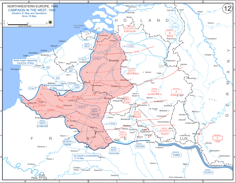
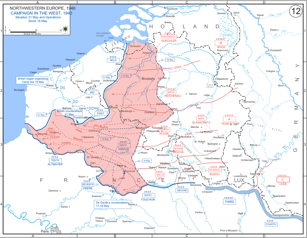
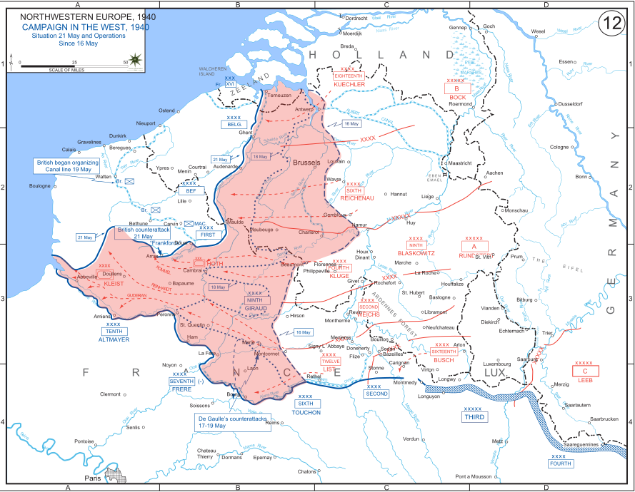
English: The German advance between 16 May and 21 May 1940. The red area denotes the territory captured by Germany during this time. The German field armies and Corps are shown in red. The operating area of the various Belgian, British, and French field armies and Army groups are shown in blue. The checkered white and blue area denotes the French Maginot Line. The commanders of the various units are shown under their respective formation. Solid lines represent the boundaries between each major unit. Dotted lines depict lines of advance. Key dates are shown in boxes. |
| Dátum | |
| Forrás | Archive link to original website used for the map and the archive link to the map source page. Current link to map, and link to map source page. |
| Szerző | The History Department of the United States Military Academy |
| Más változatok |
|


Licenc
Ezt a képet az Amerikai Egyesült Államok Szárazföldi Erőinek egy katonája vagy munkatársa készítette szolgálati ideje alatt. Az Egyesült Államok jogszabályai értelmében ez a kép közkincsnek minősül.
|
 |
Fájltörténet
Kattints egy időpontra, hogy a fájl akkori állapotát láthasd.
| Dátum/idő | Bélyegkép | Felbontás | Feltöltő | Megjegyzés | |
|---|---|---|---|---|---|
| aktuális | 2011. december 29., 21:07 | | 889 × 690 (2,06 MB) | Zscout370 | The text was displaying oddly in this SVG. |
| 2011. december 29., 21:07 |  | 889 × 690 (463 KB) | Addihockey10 | test | |
| 2010. szeptember 24., 04:58 |  | 889 × 690 (334 KB) | Tazadeperla | {{Information |Description={{en|1=Vector version of file 1940FranceBlitz.jpg}} |Source=http://www.dean.usma.edu/history/web03/atlases/ww2%20europe/WWIIEuropeIndex.html |Author=The History Dept at the United States Army Academy |Date= |Permission= |other_v |
Fájlhasználat
Ezt a fájlt nem használja egyetlen lap sem.
Globális fájlhasználat
A következő wikik használják ezt a fájlt:
- Használata itt: af.wikipedia.org
- Használata itt: ar.wikipedia.org
- Használata itt: azb.wikipedia.org
- Használata itt: bn.wikipedia.org
- Használata itt: br.wikipedia.org
- Használata itt: bs.wikipedia.org
- Használata itt: ca.wikipedia.org
- Használata itt: cs.wikipedia.org
- Használata itt: da.wikipedia.org
- Használata itt: en.wikipedia.org
- Használata itt: fi.wikipedia.org
- Használata itt: fr.wikipedia.org
- Használata itt: gl.wikipedia.org
- Használata itt: he.wikipedia.org
- Használata itt: id.wikipedia.org
- Használata itt: it.wikipedia.org
- Használata itt: ja.wikipedia.org
- Használata itt: ko.wikipedia.org
- Használata itt: lt.wikipedia.org
- Használata itt: lv.wikipedia.org
- Használata itt: nl.wikipedia.org
- Használata itt: no.wikipedia.org
- Használata itt: pl.wikipedia.org
- Használata itt: pt.wikipedia.org
- Használata itt: ro.wikipedia.org
- Használata itt: ru.wikipedia.org
- Használata itt: simple.wikipedia.org
- Használata itt: sl.wikipedia.org
- Használata itt: sr.wikipedia.org
A fájl globális használatának megtekintése