
Fájl:Map of the Original City of Philadelphia in 1682 by Thomas Holme.jpg

Az előnézet mérete: 800 × 565 képpont További felbontások: 320 × 226 képpont | 640 × 452 képpont | 1 024 × 723 képpont | 1 280 × 903 képpont | 2 560 × 1 806 képpont | 5 330 × 3 761 képpont.
Eredeti fájl (5 330 × 3 761 képpont, fájlméret: 10,26 MB, MIME-típus: image/jpeg)
|
Ez a fájl a Wikimedia Commonsból származik. Az alább látható leírás az ottani dokumentációjának másolata. A Commons projekt szabad licencű kép- és multimédiatár. Segíts te is az építésében! |
Összefoglaló
| Leírás |
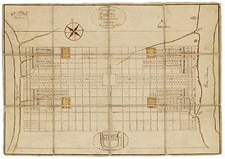
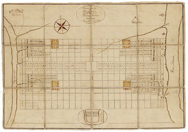
English: Holme, Thomas (1683). A Portraiture of the City of Philadelphia (map): In the province of Pennsylvania in America. London: Sold by Andrew Sowle in Shoreditch. In 1682, William Penn appointed Holme surveyor-general of Pennsylvania and charged him with the task of laying out the "greene country towne" that Penn envisioned along the Delaware River. The site that Penn acquired for the city of Philadelphia stretched two miles east to west across a tract of land situated between the Delaware and Schuylkill Rivers; all told, the rectangular grid of land comprised twelve thousand acres. Holme imposed an orderly grid plan on the site, with streets organized around a large square in the center of the town and four smaller squares, one in each quadrant. The grid also included two main streets, Broad and High (present-day Market), which were kept wide in hopes of preventing the kind of fire that destroyed London in 1666. Completed in 1683, this map was used for both reference and promotional purposes to show the unique layout of William's Penn emerging city. From the Historical Society of Pennsylvania: https://hsp.org/education/primary-sources/a-map-of-the-original-city-of-philadelphia |
| Dátum | |
| Forrás | https://hsp.org/education/primary-sources/a-map-of-the-original-city-of-philadelphia |
| Szerző | Thomas Holme |
Licenc
Ez az alkotás az Amerikai Egyesült Államokban közkincsnek számít, mivel 1929. január 1. előtt publikálták.
A közkincsnek számító munkáknak mind az Egyesült Államokban, mind a származási országban ki kell kerülniük a szerzői jogokat védő törvények hatálya alól. Ha egy alkotás nem az Egyesült Államokban készült, akkor a származási országban érvényben lévő szerzői jogi státuszát is közölni kell.
|
Fájltörténet
Kattints egy időpontra, hogy a fájl akkori állapotát láthasd.
| Dátum/idő | Bélyegkép | Felbontás | Feltöltő | Megjegyzés | |
|---|---|---|---|---|---|
| aktuális | 2020. január 23., 22:57 | | 5 330 × 3 761 (10,26 MB) | N-gio | Sharpened focus, color, and contrast |
| 2020. január 23., 20:37 |  | 5 330 × 3 761 (1,9 MB) | N-gio | User created page with UploadWizard |
Fájlhasználat
Ezt a fájlt nem használja egyetlen lap sem.
Globális fájlhasználat
A következő wikik használják ezt a fájlt:
- Használata itt: en.wikipedia.org
- Használata itt: he.wikipedia.org
- Használata itt: tr.wikipedia.org