
Fájl:The Citadel of Alanya.jpg
Eredeti fájl (1 000 × 750 képpont, fájlméret: 360 KB, MIME-típus: image/jpeg)
|
Ez a fájl a Wikimedia Commonsból származik. Az alább látható leírás az ottani dokumentációjának másolata. A Commons projekt szabad licencű kép- és multimédiatár. Segíts te is az építésében! |
Összefoglaló
| Leírás |
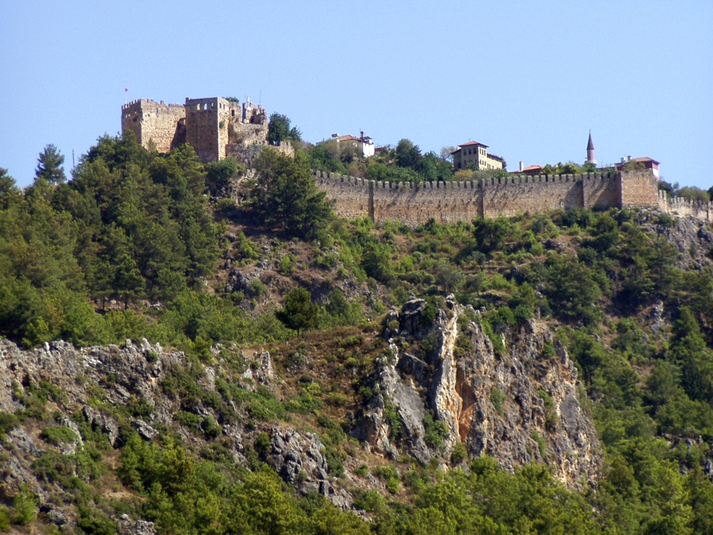
The citadel viewed from the city. The Citadel of Alanya, the walls of which are nearly 6.5 kilometres long, is on a peninsula whose height is up to 250 metres from the sea level. Although the settlement on Alanya peninsula, also known as Kandeleri, dates back to the Hellenistic Era, its cultural characteristics that can be seen today are thanks to Selcuks of the 13th century. The citadel was constructed on the demand of the Sultan of Selcuks, Alaaddin Keykubat, who conquered and had the city rebuilt in 1221. The citadel has 83 towers and 140 bastions. Nearly 400 cisterns were built to supply the city surrounded by walks in the medieval times with water. Some of the cisterns are still used today. The Seljuk Empire used Alanya as a second capital city in addition to Konya and used the city as a winter residence and made improvements there. Mongol attacks in 1243 and the Invasion of Anatolia by Egyptian Memluks weakened the Seljuk Empire which was divided in 1300, and the region came under the reign of the Karamano?ullar? dynasty. In 1427 Alanya was sold to the Memluk Sultan for five thousand gold pieces, and then in 1471 the city was included within the borders of the Ottoman Empire by Mehmet II The Conqueror. ( www.alanya.com.tr/en/47-Historical-Places.html ) |
| Dátum | |
| Forrás |
Türkiye - The Citadel of Alanya
|
| Szerző | Robin & Bazylek from Kraków, Poland |
| Fényképező elhelyezkedése | | További képek erről a helyről: OpenStreetMap |
|---|
Licenc
- A következőket teheted a művel:
- megoszthatod – szabadon másolhatod, terjesztheted, bemutathatod és előadhatod a művet
- feldolgozhatod – származékos műveket hozhatsz létre
- Az alábbi feltételekkel:
- Nevezd meg! – A szerzőt megfelelően fel kell tüntetned, hivatkozást kell létrehoznod a licencre és jelezned kell, ha a művön változtatást hajtottál végre. Ezt bármilyen észszerű módon megteheted, kivéve oly módon, ami azt sugallná hogy a jogosult támogat téged vagy a felhasználásod körülményeit.
| Ezt a képet, amit eredetileg a Flickr képmegosztón tettek közzé, egy adminisztrátor vagy megtekintő, File Upload Bot (Magnus Manske) April 21, 2009 napon ellenőrizte, és úgy találta, hogy a kép elérhető a Flickr-en az itt látható licenc alatt. |
Fájltörténet
Kattints egy időpontra, hogy a fájl akkori állapotát láthasd.
| Dátum/idő | Bélyegkép | Felbontás | Feltöltő | Megjegyzés | |
|---|---|---|---|---|---|
| aktuális | 2009. április 21., 17:59 | | 1 000 × 750 (360 KB) | File Upload Bot (Magnus Manske) | {{Information |Description= The citadel viewed from the city. The Citadel of Alanya, the walls of which are nearly 6.5 kilometres long, is on a peninsula whose height is up to 250 metres from the sea level. Although the settlement on Alanya peninsula, a |
Fájlhasználat
Az alábbi lap használja ezt a fájlt:
Globális fájlhasználat
A következő wikik használják ezt a fájlt:
- Használata itt: ar.wikipedia.org
- Használata itt: ba.wikipedia.org
- Használata itt: de.wikipedia.org
- Használata itt: es.wikipedia.org
- Használata itt: fr.wikipedia.org
- Használata itt: hy.wikipedia.org
- Használata itt: pt.wikipedia.org
- Használata itt: ru.wikipedia.org
- Használata itt: tg.wikipedia.org