
Fájl:Location Ryukyu Islands.PNG

Az előnézet mérete: 550 × 599 képpont További felbontások: 220 × 240 képpont | 441 × 480 képpont | 906 × 987 képpont.
Eredeti fájl (906 × 987 képpont, fájlméret: 151 KB, MIME-típus: image/png)
|
Ez a fájl a Wikimedia Commonsból származik. Az alább látható leírás az ottani dokumentációjának másolata. A Commons projekt szabad licencű kép- és multimédiatár. Segíts te is az építésében! |
Összefoglaló
| Leírás |
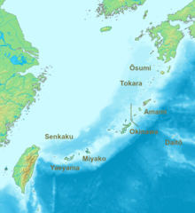
English: Location map of the Ryukyu islands (Nansei islands). According to the standardized geographical names of Japan, the Nansei Islands (南西諸島, Nansei Shotō, lit. "Southwest Islands") cover the entire island chain: the Ōsumi, Tokara, Amami, Okinawa, Sakishima Islands (further divided into the Miyako and Yaeyama Islands), the Senkaku Islands, and the Daitō Islands, with Yonaguni the westernmost. |
| Dátum | 2006, 2022 |
| Forrás | A feltöltő saját munkája |
| Szerző | Nanshu, Michiel1972 |
| Más változatok | alternative version: File:Location of the Ryukyu Islands.JPG |
Licenc
This image is in the public domain because it came from the site https://www.demis.nl/products/web-map-server/examples/ and was released by the copyright holder. Permission is granted to copy, distribute and/or modify this map since it is based on free of copyright images from: www.demis.nl. See also approval email on de.wp and its clarification.
|
| This work has been released into the public domain by its copyright holder, www.demis.nl. This applies worldwide. Egyes országokban ez jogilag nem lehetséges. Ha így van, akkor: www.demis.nl jogot ad bárkinek, hogy bármilyen célból, feltétel nélkül használhassa ezt a fájlt, kivéve a törvény által kötelezően előírt feltételeket.
|
Fájltörténet
Kattints egy időpontra, hogy a fájl akkori állapotát láthasd.
| Dátum/idő | Bélyegkép | Felbontás | Feltöltő | Megjegyzés | |
|---|---|---|---|---|---|
| aktuális | 2022. május 21., 09:53 | | 906 × 987 (151 KB) | A1Cafel | Reverted to version as of 08:43, 3 April 2022 (UTC) |
| 2022. május 13., 09:26 |  | 2 309 × 1 594 (527 KB) | Sturmgewehr88 | Higher resolution map | |
| 2022. április 3., 10:43 |  | 906 × 987 (151 KB) | Nanshu | Adjust locations. Larger labels. | |
| 2006. január 20., 00:45 |  | 482 × 377 (85 KB) | Michiel1972 | *Location_Ryukyu_Islands {{demis}} |
Fájlhasználat
Ezt a fájlt nem használja egyetlen lap sem.
Globális fájlhasználat
A következő wikik használják ezt a fájlt:
- Használata itt: ar.wikipedia.org
- Használata itt: en.wikipedia.org
- Használata itt: fr.wikipedia.org
- Használata itt: hak.wikipedia.org
- Használata itt: ro.wikipedia.org
- Használata itt: sn.wikipedia.org
- Használata itt: uk.wikipedia.org
- Használata itt: zh-min-nan.wikipedia.org
- Használata itt: zh-yue.wikipedia.org
- Használata itt: zh.wikipedia.org