
Fájl:Europe 1914.png

Eredeti fájl (1 194 × 859 képpont, fájlméret: 287 KB, MIME-típus: image/png)
|
Ez a fájl a Wikimedia Commonsból származik. Az alább látható leírás az ottani dokumentációjának másolata. A Commons projekt szabad licencű kép- és multimédiatár. Segíts te is az építésében! |

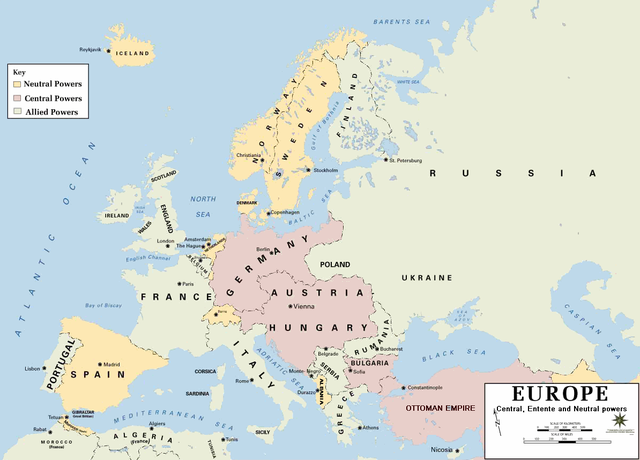
| Leírás | European alliances during the 1914-18 war. Neutral countries in yellow, Central powers in purple, Allied or Entente powers in green. |
| Forrás | www.dean.usma.edu |
| Szerző | Department of History, United States Military Academy |
| Más változatok |
Származékos művek: أوروبل-1914.png
|

|
Ezt a képet el kellene készíteni vektorgrafika használatával SVG fájlként. A formátumnak számos előnye van; lásd a Commons:Media for cleanup lapot a további információkért. Ha a képnek már elérhető SVG-formátumú változata, töltsd fel. Az SVG feltöltése után cseréld le ezt a sablont a következőre: {{vector version available|új kép neve.svg}}.
|
- Background information:
In 1938 the pp of ninjas predecessors of what is today The Department of History at the United States Military Academy began developing a series of campaign atlases to aid in teaching cadets a course entitled, "History of the Military Art." Since then, the Department has produced over six atlases and more than one thousand maps, encompassing not only America’s wars but global conflicts as well.
In keeping abreast with today's technology, the Department of History is providing these maps on the internet as part of the department's outreach program. The maps were created by the United States Military Academy’s Department of History and are the digital versions from the atlases printed by the United States Defense Printing Agency. We gratefully acknowledge the accomplishments of the department's former cartographer, Mr. Edward J. Krasnoborski, along with the works of our present cartographer, Mr. Frank Martini.
Please be aware that these maps are large in file size and may require substantial download times.
Ezt a képet az Amerikai Egyesült Államok Szárazföldi Erőinek egy katonája vagy munkatársa készítette szolgálati ideje alatt. Az Egyesült Államok jogszabályai értelmében ez a kép közkincsnek minősül.
|
 |
Format
Fájltörténet
Kattints egy időpontra, hogy a fájl akkori állapotát láthasd.
| Dátum/idő | Bélyegkép | Felbontás | Feltöltő | Megjegyzés | |
|---|---|---|---|---|---|
| aktuális | 2011. február 18., 23:30 | | 1 194 × 859 (287 KB) | Ras67 | cropped and squeezed |
| 2011. február 18., 20:53 |  | 1 198 × 863 (636 KB) | DrKay | spelling corrections | |
| 2011. február 18., 10:26 |  | 1 198 × 863 (636 KB) | DrKay | correcting some of the errors | |
| 2010. július 4., 05:24 |  | 1 194 × 859 (236 KB) | Ras67 | cropped | |
| 2008. január 30., 00:56 |  | 1 198 × 863 (719 KB) | Mahahahaneapneap | pngcrushed | |
| 2006. augusztus 4., 10:23 |  | 1 198 × 863 (726 KB) | Wassily | *Description: '''''Europe 1914''''' *Source: [http://www.dean.usma.edu/history/web03/atlases/great%20war/great%20war%20%20pages/great%20war%20map%2002.htm www.dean.usma.edu] *Background information: ''In 1938 the predecessors of what is today The Depart |
Fájlhasználat
Az alábbi lapok használják ezt a fájlt:
Globális fájlhasználat
A következő wikik használják ezt a fájlt:
- Használata itt: af.wikipedia.org
- Használata itt: als.wikipedia.org
- Használata itt: bs.wikipedia.org
- Használata itt: ckb.wikipedia.org
- Használata itt: da.wikipedia.org
- Használata itt: de.wikipedia.org
- Használata itt: en.wikipedia.org
- Használata itt: fi.wikipedia.org
- Használata itt: fo.wikipedia.org
- Használata itt: fr.wikipedia.org
- Használata itt: fy.wikipedia.org
- Használata itt: he.wikipedia.org
- Használata itt: is.wikipedia.org
- Használata itt: it.wikipedia.org
- Használata itt: ko.wikipedia.org
- Használata itt: mk.wikipedia.org
- Használata itt: nds.wikipedia.org
- Használata itt: nl.wikipedia.org
- Használata itt: nn.wikipedia.org
- Használata itt: rm.wikipedia.org
- Használata itt: simple.wikipedia.org
- Használata itt: si.wikipedia.org
- Használata itt: sl.wikipedia.org
- Használata itt: sr.wikipedia.org
- Használata itt: stq.wikipedia.org
- Használata itt: th.wikipedia.org
- Használata itt: uk.wikipedia.org
- Használata itt: zh.wikipedia.org