
Fájl:Ebola Outbreak Map (ongoing).png

Eredeti fájl (2 454 × 1 502 képpont, fájlméret: 841 KB, MIME-típus: image/png)
|
Ez a fájl a Wikimedia Commonsból származik. Az alább látható leírás az ottani dokumentációjának másolata. A Commons projekt szabad licencű kép- és multimédiatár. Segíts te is az építésében! |
.png)

|
Ez a fájl frissíthető új információkkal. Ha szeretnéd a fájl egy adott változatát használni a későbbi frissítések nélkül, töltsd fel a kívánt verziót egy új néven. |
Összefoglaló
| Leírás |
English: Continuation of the moribund map located at https://commons.wikimedia.org/wiki/File:Map_of_Ebola_Outbreak_-_1_October_2014.svg |
| Dátum | |
| Forrás | A feltöltő saját munkája |
| Szerző | Раціональне анархіст |
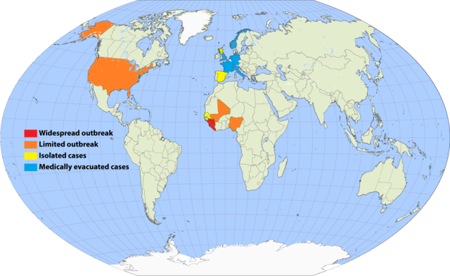
I've undertaken to update an older map, and to simplify the previous cluttered color scheme by removing recorded deaths versus none (a fiddly distinction which required excessive updating). Since a November 20 Wikimedia security rule change, it is apparently no longer possible to upload the .svg scalable format. This file is a 150% .png enlargement of the .svg working document carried over from the previous source.
Suggested rules for updating:
- BLUE: Medically evacuated cases: Any area in which an Ebola case from elsewhere has been treated. Blue regions do not become another color unless there's an actual local outbreak (either due to it escaping the evac facility, or arriving from another source). An ex-blue color cannot become blue again unless it achieves green first (42-day limit passage), then another evac case arrives.
- YELLOW: Isolated cases: Anywhere Ebola is "loose", but for which all or nearly all known and suspected cases are in treatment or quarantine.
- ORANGE: Limited outbreak: An arbitrarily moderate number of persons are infected, including unknown infected "spreaders", but the medical infrastructure is not overwhelmed.
- RED: Widespread outbreak: An out-of-control situation overwhelming available medical infrastructure. Many unidentified infected "spreaders".
Progression: YELLOW > ORANGE > RED > ORANGE > YELLOW.
Please refrain from updating this file if you are not in possession of a master .svg file, and posting a master-derived image in the same format and dimensions as the preceding imagery.
Licenc

|
Ez a fájl szabadon másolható, terjeszthető és/vagy módosítható a GNU Szabad Dokumentációs Licenc feltételei alapján, az 1.2 vagy későbbi, a Free Software Foundation által publikált Nem Változtatható szakaszok, Címlapszövegek és Hátlapszövegek nélküli változat szerint. E licenc egy példánya a GNU Szabad Dokumentációs Licenc című fejezetben olvasható. |
- A következőket teheted a művel:
- megoszthatod – szabadon másolhatod, terjesztheted, bemutathatod és előadhatod a művet
- feldolgozhatod – származékos műveket hozhatsz létre
- Az alábbi feltételekkel:
- Nevezd meg! – A szerzőt megfelelően fel kell tüntetned, hivatkozást kell létrehoznod a licencre és jelezned kell, ha a művön változtatást hajtottál végre. Ezt bármilyen észszerű módon megteheted, kivéve oly módon, ami azt sugallná hogy a jogosult támogat téged vagy a felhasználásod körülményeit.
- Így add tovább! – Ha megváltoztatod, átalakítod, feldolgozod ezt a művet, a közreműködésedet csak az eredetivel megegyező vagy hasonló licenc alatt terjesztheted.
Fájltörténet
Kattints egy időpontra, hogy a fájl akkori állapotát láthasd.
.png&dir=prev)
.png&offset=20150807001640)
.png&offset=&limit=20)
.png&offset=&limit=50)
.png&offset=&limit=100)
.png&offset=&limit=250)
.png&offset=&limit=500)
| Dátum/idő | Bélyegkép | Felbontás | Feltöltő | Megjegyzés | |
|---|---|---|---|---|---|
| aktuális | 2017. szeptember 17., 01:33 | | 2 454 × 1 502 (841 KB) | Jamie Tubers | According to the discussion had on the article talkpage: https://en.wikipedia.org/wiki/Talk:West_African_Ebola_virus_epidemic/Archive_8#July_2016_map_in_Epidemiology:_Outbreak_section |
| 2017. április 9., 05:00 |  | 2 454 × 1 502 (854 KB) | Agricolae | recolor to reflect historical perspective rather than current situation (after outbreak is over everywhere) | |
| 2016. szeptember 14., 15:16 |  | 2 454 × 1 502 (861 KB) | Heitordp | Surveillance period ended in all countries | |
| 2016. április 3., 13:12 |  | 2 454 × 1 502 (880 KB) | The Anome | Isolated outbreaks in both Guinea and Liberia | |
| 2016. április 1., 01:14 |  | 2 454 × 1 502 (861 KB) | Heitordp | Sierra Leone free, new cases in Guinea | |
| 2016. február 8., 00:05 |  | 2 454 × 1 502 (826 KB) | Heitordp | Liberia free again, isolated cases in Sierra Leone | |
| 2015. december 29., 15:58 |  | 2 454 × 1 502 (885 KB) | The Anome | Guinea now Ebola-free as of 29 December 2015, Liberia only with yellow status now | |
| 2015. november 22., 03:10 |  | 2 454 × 1 502 (826 KB) | Heitordp | Sierra Leone free, new case in Liberia | |
| 2015. szeptember 5., 09:04 |  | 2 454 × 1 502 (824 KB) | Раціональне анархіст | Liberia clear again. | |
| 2015. augusztus 7., 02:16 |  | 2 454 × 1 502 (824 KB) | Раціональне анархіст | Sierra Leone and Guinea improved to yellow after neither country has had more than five new cases per week for two reporting cycles. |
Fájlhasználat
Az alábbi lap használja ezt a fájlt:
Globális fájlhasználat
A következő wikik használják ezt a fájlt:
- Használata itt: ca.wikipedia.org
- Használata itt: en.wikipedia.org
- Használata itt: en.wikiversity.org
- Használata itt: fi.wikipedia.org
- Használata itt: fr.wikinews.org
- Használata itt: ja.wikipedia.org
- Használata itt: ko.wikipedia.org
- Használata itt: no.wikipedia.org
- Használata itt: pl.wikipedia.org
- Használata itt: ro.wikipedia.org
- Használata itt: ru.wikipedia.org
- Használata itt: rw.wikipedia.org
- Használata itt: uk.wikipedia.org
- Használata itt: www.wikidata.org
.png)