
Fájl:Departments of French Empire North 1811-de.svg

Ennek a(z) SVG fájlnak ezen PNG formátumú előnézete: 406 × 599 képpont. További felbontások: 162 × 240 képpont | 325 × 480 képpont | 520 × 768 képpont | 694 × 1 024 képpont | 1 387 × 2 048 képpont | 525 × 775 képpont.
Eredeti fájl (SVG fájl, névlegesen 525 × 775 képpont, fájlméret: 52 KB)
|
Ez a fájl a Wikimedia Commonsból származik. Az alább látható leírás az ottani dokumentációjának másolata. A Commons projekt szabad licencű kép- és multimédiatár. Segíts te is az építésében! |
Összefoglaló
| Leírás |
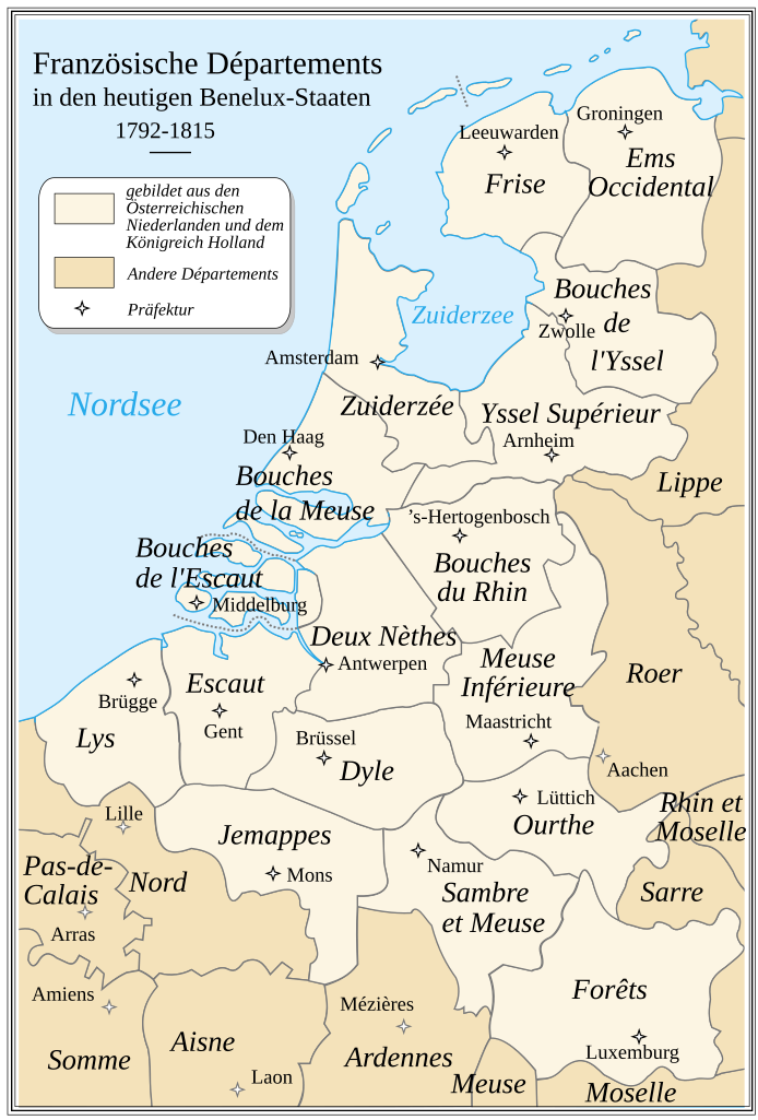
Deutsch: Französische Départemets in den heutigen Benelux-Staaten zur Zeit des Émpire 1811. Die Karte beruht auf einer historischen Vorlage, die nicht sehr präzise ist.
English: French Departements of the North of the first Empire (1811). Be careful: this map is an historical map. The precision is not sufficient for a modern use.
Français : Les départements du Nord du 1er Empire français (1811). Attention : cette carte est une carte historique. La qualité de sa précision ne permet pas une utilisation dans un contexte moderne. |
||
| Dátum | |||
| Forrás |
Nach einer Kartenvorlage aus dem Jahr 1811 von Drioux und Leroy. Ez a fájl ebből származik: Departments of French Empire North 1811-fr.svg |
||
| Szerző | |||
| Engedély (Fájl újrafelhasználása) |
|
Ez vektorgrafikus kép Inkscape segítségével készült .

|
Ez az SVG-fájl beágyazott szöveget tartalmaz, amit könnyen magyarra lehetne fordítani a bármilyen megfelelő SVG- vagy szövegszerkesztővel, vagy az SVG-fordító eszközzel. További információkért lásd: SVG-fájlok fordítása. |
Fájltörténet
Kattints egy időpontra, hogy a fájl akkori állapotát láthasd.
| Dátum/idő | Bélyegkép | Felbontás | Feltöltő | Megjegyzés | |
|---|---|---|---|---|---|
| aktuális | 2020. március 12., 10:44 | | 525 × 775 (52 KB) | Furfur | Detail |
| 2020. február 26., 19:09 |  | 525 × 775 (52 KB) | Furfur | typo | |
| 2020. február 26., 03:38 |  | 525 × 775 (52 KB) | Furfur | == {{int:filedesc}} == {{Information |Description= {{de|1=Französische Départemets in den heutigen Benelux-Staaten zur Zeit des Émpire 1811. Die Karte beruht auf einer historischen Vorlage, die nicht sehr präzise ist.}} {{en|1=French Departements of the North of the first Empire (1811). Be careful: this map is an historical map. The precision is not sufficient for a modern use.}} {{fr|1=Les départements du Nord du 1er Empire français (1811). Attention : cette carte est une carte historique. L... |
Fájlhasználat
Az alábbi lap használja ezt a fájlt:
Globális fájlhasználat
A következő wikik használják ezt a fájlt:
- Használata itt: de.wikipedia.org
- Königreich der Vereinigten Niederlande
- Département Ourthe
- Département Meuse-Inférieure
- Département Forêts
- Département Ems-Occidental
- Département Yssel-Supérieur
- Département Zuyderzée
- Département Bouches-du-Rhin
- Département Escaut
- Département Bouches-de-la-Meuse
- Département Bouches-de-l’Yssel
- Département Sambre-et-Meuse
- Département Bouches-de-l’Escaut
- Département Dyle
- Département Frise
- Département Deux-Nèthes
- Département Jemappes
- Département Lys
- Consistoire Krefeld
- August Karl Wilhelm Weissenbruch
- Belgische Staatsbürgerschaft