
Fájl:Aldwych, Bush House, WC2 - geograph.org.uk - 668798.jpg
Nem érhető el nagyobb felbontású változat.
Aldwych,_Bush_House,_WC2_-_geograph.org.uk_-_668798.jpg (640 × 475 képpont, fájlméret: 87 KB, MIME-típus: image/jpeg)
|
Ez a fájl a Wikimedia Commonsból származik. Az alább látható leírás az ottani dokumentációjának másolata. A Commons projekt szabad licencű kép- és multimédiatár. Segíts te is az építésében! |
Összefoglaló
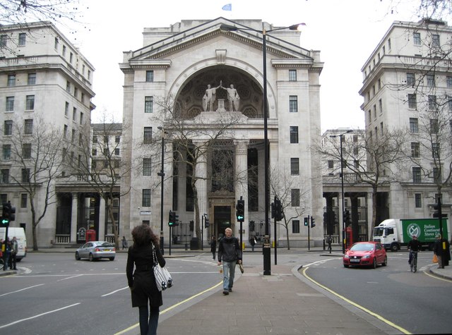
| Leírás |
English: Aldwych: Bush House, WC2 The description of Bush House on the BBC's website is concise and informative http://www.bbc.co.uk/heritage/in_depth/buildings/bush_house.shtml
All I would add is that the blue flag flying on the top of Bush House in this image is that of the BBC World Service. The lack of symmetry in the road layout, where there is a wide southbound carriageway and a narrow northbound carriageway, can be explained by the fact that some northbound traffic here is running in the Strand Underpass, which is directly beneath the photographer, and that there is no southbound equivalent. See 668779 for a view in the reverse direction from this viewpoint. |
| Dátum | |
| Forrás | From geograph.org.uk |
| Szerző | Nigel Cox |
| Így nevezd meg (a licenc megköveteli) | Nigel Cox / Aldwych: Bush House, WC2 / |
| Fényképező elhelyezkedése | | További képek erről a helyről: OpenStreetMap |
|---|
_heading:157.00&language=hu)
| Objektum elhelyezkedése | | További képek erről a helyről: OpenStreetMap |
|---|
_heading:157.00&language=hu)
Licenc

|
This image was taken from the Geograph project collection. See this photograph's page on the Geograph website for the photographer's contact details. The copyright on this image is owned by Nigel Cox and is licensed for reuse under the Creative Commons Attribution-ShareAlike 2.0 license.
|
Ez a fájl a Creative Commons Nevezd meg! – Így add tovább! 2.0 Generic licenc alapján használható fel.
Így nevezd meg: Nigel Cox
- A következőket teheted a művel:
- megoszthatod – szabadon másolhatod, terjesztheted, bemutathatod és előadhatod a művet
- feldolgozhatod – származékos műveket hozhatsz létre
- Az alábbi feltételekkel:
- Nevezd meg! – A szerzőt megfelelően fel kell tüntetned, hivatkozást kell létrehoznod a licencre és jelezned kell, ha a művön változtatást hajtottál végre. Ezt bármilyen észszerű módon megteheted, kivéve oly módon, ami azt sugallná hogy a jogosult támogat téged vagy a felhasználásod körülményeit.
- Így add tovább! – Ha megváltoztatod, átalakítod, feldolgozod ezt a művet, a közreműködésedet csak az eredetivel megegyező vagy hasonló licenc alatt terjesztheted.
Fájltörténet
Kattints egy időpontra, hogy a fájl akkori állapotát láthasd.
| Dátum/idő | Bélyegkép | Felbontás | Feltöltő | Megjegyzés | |
|---|---|---|---|---|---|
| aktuális | 2011. február 7., 19:42 | | 640 × 475 (87 KB) | GeographBot | == {{int:filedesc}} == {{Information |description={{en|1=Aldwych: Bush House, WC2 The description of Bush House on the BBC's website is concise and informative http://www.bbc.co.uk/heritage/in_depth/buildings/bush_house.shtml All I would add is that the |
Fájlhasználat
Az alábbi lapok használják ezt a fájlt:
Globális fájlhasználat
A következő wikik használják ezt a fájlt:
- Használata itt: bn.wikipedia.org
- Használata itt: en.wikipedia.org
- Használata itt: hy.wikipedia.org
- Használata itt: it.wikipedia.org
- Használata itt: pnb.wikipedia.org
- Használata itt: pt.wikipedia.org
- Használata itt: ru.wikipedia.org
- Használata itt: sv.wikipedia.org
- Használata itt: ur.wikipedia.org
- Használata itt: uz.wikipedia.org