
Fájl:Aerial view Loos-Hulluch trench system July 1917.jpg

Eredeti fájl (742 × 864 képpont, fájlméret: 542 KB, MIME-típus: image/jpeg)
|
Ez a fájl a Wikimedia Commonsból származik. Az alább látható leírás az ottani dokumentációjának másolata. A Commons projekt szabad licencű kép- és multimédiatár. Segíts te is az építésében! |
| Leírás |
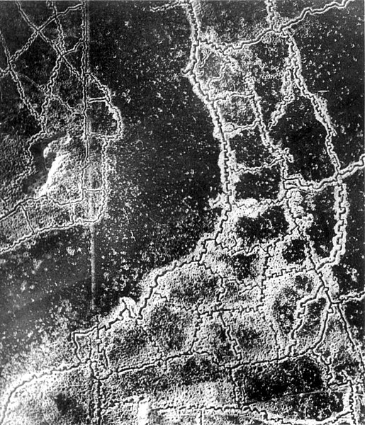
English: An aerial reconnaissance photograph of the opposing trenches and no-man's land between Loos-en-Gohelle and Hulluch in Artois, France, taken at 7.15 pm, 22 July 1917. German trenches are at the right and bottom, British trenches are at the top left. The vertical line to the left of centre indicates the course of a pre-war road or track.
The location is Hill 70, attacked and taken between 15 and 25 August 1917 by the Canadian Corps. Français : Photographie de reconnaissance aérienne des tranchées adverses et du no-man's-land qui les sépare. Les tranchées allemandes sont en bas à droite, les tranchées à gauches sont anglaises. La ligne verticale sur la gauche est tout ce qui reste d'une route. Photo prise entre Loos et Hulluch, en Artois (France) à 19h15, le 22 juillet 1917.
Русский: Аэрофотосъемка траншей (окопов) и ходов сообщения противников и разделяющей их ничейной земли, Западноевропейский театр войны. Справа внизу немецкие окопы, слева — английские, канадские. Вертикальная линия слева — это всё, что осталось от дороги. Аэроснимок сделан между Лоосом и Хюлухом, в Артуа (Франция) в 19.15, 22 июля 1917 года. |
|||
| Dátum | ||||
| Forrás |
|
|||
| Szerző | Ismeretlen | |||
| Engedély (Fájl újrafelhasználása) |
|


| Fényképező elhelyezkedése | | További képek erről a helyről: OpenStreetMap |
|---|
Note: Location is approximate.

|
Ez a kép elbírálásra került a Értékes kép irányelvek alapján, amikor is a Commons egyik legértékesebb képévé nyilvánították az alábbi területen: World War I trench systems, aerial view. Megnézheted a jelölését a Commons:Valued image candidates/Aerial view Loos-Hulluch trench system July 1917.jpg lapon. |
Fájltörténet
Kattints egy időpontra, hogy a fájl akkori állapotát láthasd.
| Dátum/idő | Bélyegkép | Felbontás | Feltöltő | Megjegyzés | |
|---|---|---|---|---|---|
| aktuális | 2012. január 16., 05:12 | | 742 × 864 (542 KB) | Centpacrr | Remove text. |
| 2005. december 10., 07:49 |  | 767 × 864 (243 KB) | Gsl~commonswiki | {{PD-BritishGov}} |
Fájlhasználat
Az alábbi lap használja ezt a fájlt:
Globális fájlhasználat
A következő wikik használják ezt a fájlt:
- Használata itt: ast.wikipedia.org
- Használata itt: az.wikipedia.org
- Használata itt: be-tarask.wikipedia.org
- Használata itt: be.wikipedia.org
- Használata itt: bg.wikipedia.org
- Használata itt: br.wikipedia.org
- Használata itt: ca.wikipedia.org
- Használata itt: da.wikipedia.org
- Használata itt: de.wikipedia.org
- Használata itt: en.wikipedia.org
- Használata itt: es.wikipedia.org
- Használata itt: et.wikipedia.org
- Használata itt: fa.wikipedia.org
- Használata itt: fi.wikipedia.org
- Használata itt: fr.wikipedia.org
- Használata itt: fr.wikiversity.org
- Használata itt: gl.wikipedia.org
- Használata itt: hy.wikipedia.org
- Használata itt: id.wikipedia.org
- Használata itt: it.wikipedia.org
- Használata itt: it.wikiquote.org
- Használata itt: ja.wikipedia.org
- Használata itt: ko.wikipedia.org
- Használata itt: ml.wikipedia.org
- Használata itt: ms.wikipedia.org
- Használata itt: nl.wikipedia.org
- Használata itt: nl.wiktionary.org
- Használata itt: no.wikipedia.org
- Használata itt: oc.wikipedia.org
- Használata itt: pcd.wikipedia.org
- Használata itt: pl.wikipedia.org
A fájl globális használatának megtekintése