
Fájl:Administrative division of denmark in medieval times.jpg
Eredeti fájl (5 952 × 4 336 képpont, fájlméret: 15,8 MB, MIME-típus: image/jpeg)
|
Ez a fájl a Wikimedia Commonsból származik. Az alább látható leírás az ottani dokumentációjának másolata. A Commons projekt szabad licencű kép- és multimédiatár. Segíts te is az építésében! |
Összefoglaló
| Leírás |
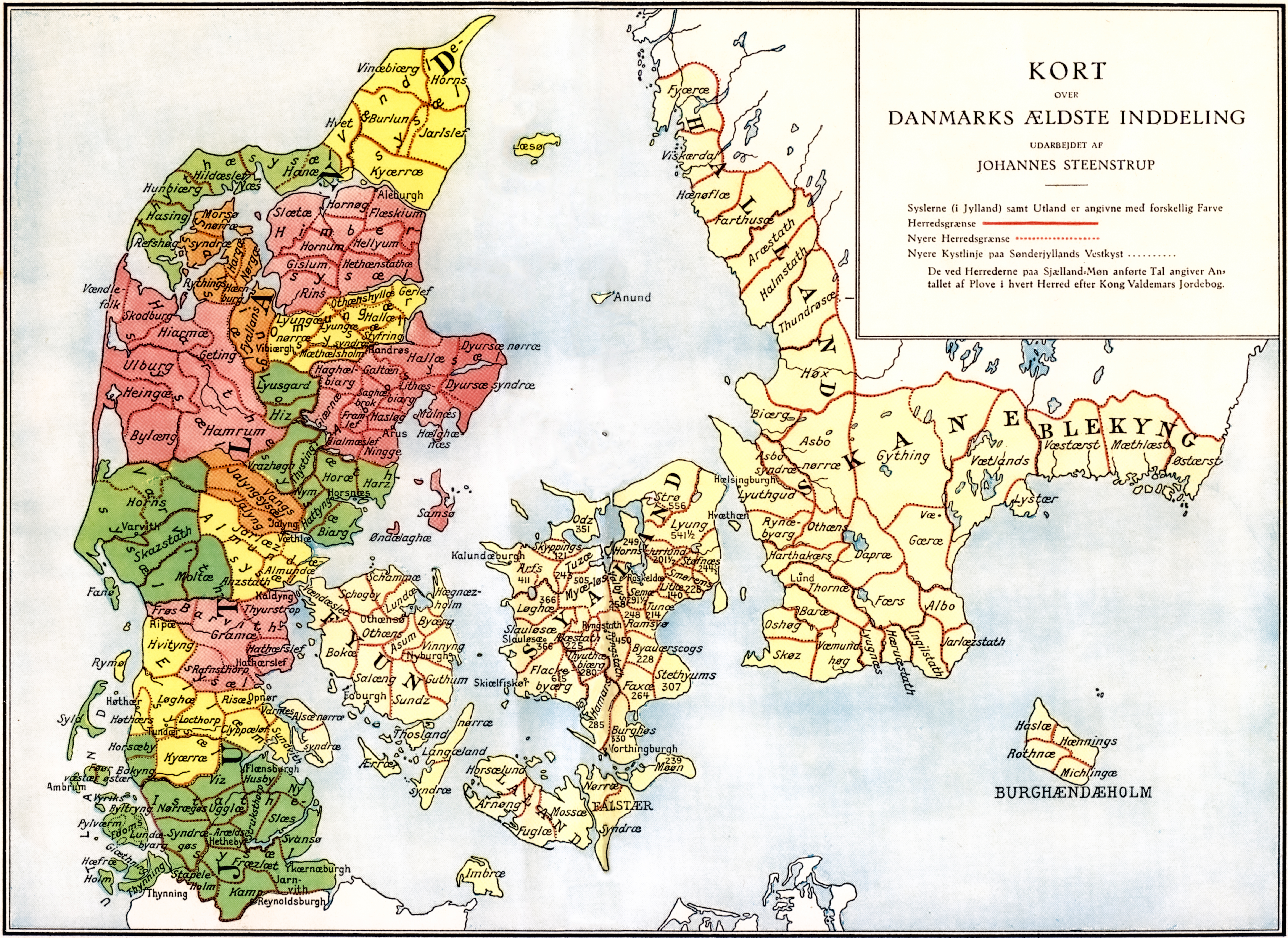
Administrative division of Denmark in Medieval times. |
||||||||||||||||||||
| Map legend | The different colors indicate the division in sysler in Jutland while the red lines indicate borders between herreder (hundreds). Dotted red lines indicate newer borders. Note:The purely ecclesiastic sysler on Zealand are not included on this map. | ||||||||||||||||||||
| Forrás | The map was made by professor Johannes Steenstrup (died 1935) for use in Danmarks Riges Historie (1900, after page 625) and is in Public Domain since Steenstrup died more than 70 years ago. | ||||||||||||||||||||
| Alkotó |
|
||||||||||||||||||||
| Engedély (Fájl újrafelhasználása) |
|
||||||||||||||||||||
| Georeferencing | If inappropriate please set warp_status = skip to hide. | ||||||||||||||||||||
| Más változatok | |||||||||||||||||||||


.jpg)

.jpg)
.jpg)
.jpg)
.jpg)
.jpg)
.jpg)
.jpg)
.jpg)
.jpg)
.jpg)
.jpg)
.jpg)


.jpg)
Fájltörténet
Kattints egy időpontra, hogy a fájl akkori állapotát láthasd.
| Dátum/idő | Bélyegkép | Felbontás | Feltöltő | Megjegyzés | |
|---|---|---|---|---|---|
| aktuális | 2019. június 12., 18:30 | | 5 952 × 4 336 (15,8 MB) | Aeroid | removed vertical lines, straight, slight color change |
| 2005. június 19., 07:36 |  | 5 952 × 4 336 (16,87 MB) | Heelgrasper | Administrative division of Denmark in Medieval times. The different colors indicate the division in "sysler" in Jutland while the red lines indicate borders between "herreder" (counties). Dotted red lines indicate never borders. The map is made by profes |
Fájlhasználat
Az alábbi lapok használják ezt a fájlt:
Globális fájlhasználat
A következő wikik használják ezt a fájlt:
- Használata itt: cs.wikipedia.org
- Használata itt: da.wikipedia.org
- Használata itt: de.wikipedia.org
- Használata itt: en.wikipedia.org
- Használata itt: eo.wikipedia.org
- Használata itt: es.wikipedia.org
- Használata itt: et.wikipedia.org
- Használata itt: fi.wikipedia.org
- Használata itt: frr.wikipedia.org
- Használata itt: fr.wikipedia.org
- Használata itt: he.wikipedia.org
- Használata itt: id.wikipedia.org
- Használata itt: it.wikipedia.org
- Használata itt: ko.wikipedia.org
- Használata itt: la.wikipedia.org
- Használata itt: nds.wikipedia.org
- Használata itt: nl.wikipedia.org
- Használata itt: no.wikipedia.org
A fájl globális használatának megtekintése