
Fájl:150132main image feature 589 alaska.jpg

Eredeti fájl (5 600 × 4 400 képpont, fájlméret: 6,63 MB, MIME-típus: image/jpeg)
|
Ez a fájl a Wikimedia Commonsból származik. Az alább látható leírás az ottani dokumentációjának másolata. A Commons projekt szabad licencű kép- és multimédiatár. Segíts te is az építésében! |
Összefoglaló
| Leírás |
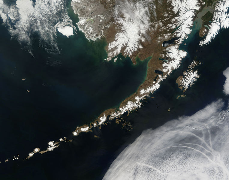
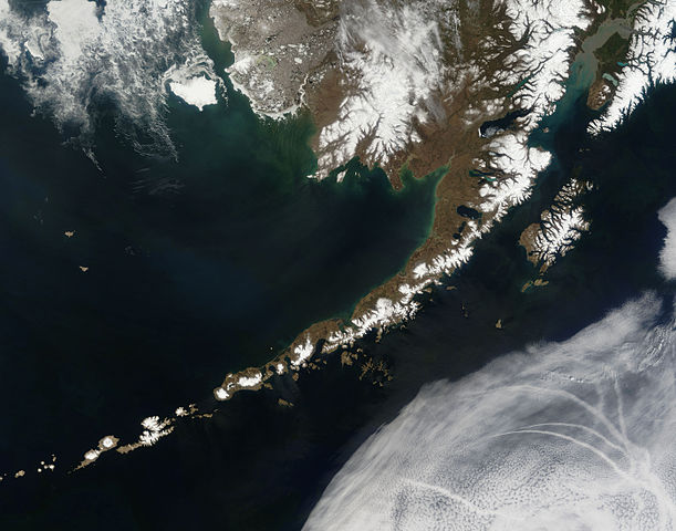
English: Satellite picture of the Aleutian Islands and the Alaska Peninsula, located in the south of the state of Alaska, United States.
Português: Imagem de satélite das Ilhas Aleutas e da Península do Alasca, localizadas no sul do estado do Alasca, Estados Unidos.
Original caption — The Aleutian Islands and the Alaskan peninsula are shown in this image acquired by the MODIS on the Terra satellite, on May 25th, 2006. The Aleutians are a chain of more than 300 small volcanic islands forming an island arc in the Northern Pacific Ocean. They extend about 1,200 miles westward from the Alaskan Peninsula. Nearly all of the islands are part of Alaska, but at the extreme western end of the archipelago are the small, geologically-related, but remote Komandorski Islands, which are considered part of Russia. The Aleutian Islands, with 57 volcanoes among them, are in the northern part of the Pacific Ring of Fire.
|
| Dátum | 2006. május 25. |
| Forrás | NASA (Image galleries) |
| Szerző | National Aeronautics and Space Administration (NASA) |
| Más változatok |
.jpg)
Assessment
Ezt a képet a 2006. szeptember 2-i nap képének választották, a következő képaláírással: Magyar: Az Aleut-szigetek és az Alaszkai-félsziget az űrből nézve Más nyelvek:
閩南語 / Bân-lâm-gú: Ùi thài-khong koàⁿ Aleutian Kûn-tó kap Alaska Poàⁿ-tó Čeština: Aleutské ostrovy z oběžné dráhy. Cymraeg: Delwedd o'r gofod o'r Ynysoedd Aleutia a'r Gorynys Alaska. Magyar: Az Aleut-szigetek és az Alaszkai-félsziget az űrből nézve Polski: Aleuty i półwysep Alaska widziane z orbity ziemskiej Slovenščina: Aleutski otoki iz vesolja. |
Licenc
| Ezt a fájlt a NASA készítette, ezért az Egyesült Államokban közkincsnek számít. A NASA szerzői jogi irányelve alapján „a NASA anyagai nem állnak szerzői jogi védelem alatt, kivéve, ha az külön jelezve van". (Lásd még: Sablon:PD-USGov, a NASA szerzői jogi- és a JPL képhasználati irányelve.) | ||
 |
Figyelmeztetések:
|
Fájltörténet
Kattints egy időpontra, hogy a fájl akkori állapotát láthasd.
| Dátum/idő | Bélyegkép | Felbontás | Feltöltő | Megjegyzés | |
|---|---|---|---|---|---|
| aktuális | 2006. július 14., 21:55 | | 5 600 × 4 400 (6,63 MB) | Felipe Menegaz | {{Information| |Description= The Aleutian Islands and the Alaskan peninsula are shown in this image acquired by the MODIS on the Terra satellite, on May 25th, 2006. The Aleutians are a chain of more than 300 small volcanic islands forming an island arc in |
Fájlhasználat
Az alábbi lapok használják ezt a fájlt:
Globális fájlhasználat
A következő wikik használják ezt a fájlt:
- Használata itt: af.wikipedia.org
- Használata itt: als.wikipedia.org
- Használata itt: bn.wikipedia.org
- Használata itt: ca.wikipedia.org
- Használata itt: cs.wikipedia.org
- Használata itt: de.wikipedia.org
- Használata itt: eo.wikipedia.org
- Használata itt: es.wikipedia.org
- Használata itt: fr.wikipedia.org
- Használata itt: gl.wikipedia.org
- Használata itt: ia.wikipedia.org
- Használata itt: it.wikipedia.org
- Használata itt: ja.wikipedia.org
- Használata itt: ko.wikipedia.org
- Használata itt: oc.wikipedia.org
- Használata itt: os.wikipedia.org
- Használata itt: pl.wikipedia.org
- Használata itt: pl.wiktionary.org
- Használata itt: pt.wikipedia.org
- Használata itt: ro.wikipedia.org
- Használata itt: ru.wikipedia.org
- Használata itt: ru.wikinews.org
- Használata itt: sah.wikipedia.org
- Használata itt: sk.wikipedia.org
- Használata itt: sr.wikipedia.org
- Használata itt: sv.wikipedia.org
- Használata itt: tr.wikipedia.org