
Fájl:Albania kosovo macedonia 6 8 century.png
Az előnézet mérete: 370 × 600 képpont További felbontások: 148 × 240 képpont | 597 × 968 képpont.
Eredeti fájl (597 × 968 képpont, fájlméret: 55 KB, MIME-típus: image/png)
|
Ez a fájl a Wikimedia Commonsból származik. Az alább látható leírás az ottani dokumentációjának másolata. A Commons projekt szabad licencű kép- és multimédiatár. Segíts te is az építésében! |
Összefoglaló
| Leírás |
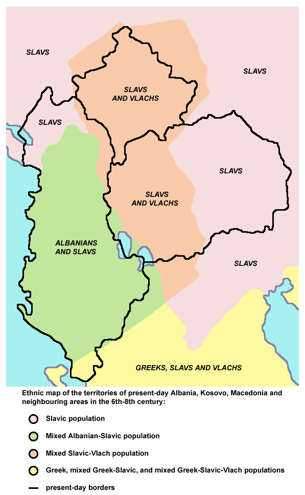
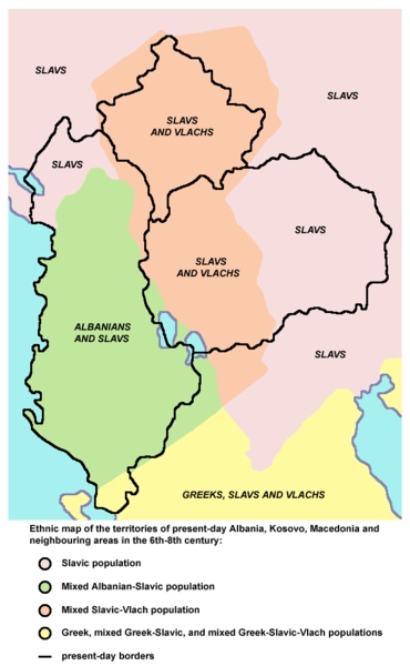
English: Ethnic map of the territories of present-day Albania, Kosovo, Macedonia and neighbouring areas in the 6th-8th century (according to the historical atlas for schools, published in Belgrade in 1970, representing a view of Yugoslav historians from that time). |
| Forrás | A feltöltő saját munkája |
| Szerző | PANONIAN |
Licenc
| Én, a szerző, ezt a művemet ezennel közkinccsé nyilvánítom. Ez a világ minden részén érvényes. Egyes országokban ez jogilag nem lehetséges. Ha így van, akkor: Jogot adok bárkinek, hogy bármilyen célból, feltétel nélkül használhassa ezt a fájlt, kivéve a törvény által kötelezően előírt feltételeket. |
References
Main reference:
- Created according to the historical map from this history atlas: "Školski istorijski atlas, Zavod za izdavanje udžbenika SR Srbije, Beograd, 1970."
Secondary references (with similar maps):
- The Times - Atlas Svjetske Povijesti, Dopunjeno izdanje za Jugoslaviju, Cankarjeva založba, Ljubljana, 1986. - this is Yugoslav (Serbo-Croatian) edition of this original source: The Times Atlas of World History, Times Books Limited, London, 1984. (in Yugoslav version from 1986 there is similar map on page number 298)
- Denis Šehić - Demir Šehić, Istorijski atlas Sveta, Beograd, 2007. (similar map is published on page number 29)
- Istorijski atlas, Geokarta, Beograd, 1999. (similar map is published on page number 33)
- The former Yugoslavia's diverse peoples: a reference sourcebook By Matjaž Klemenčič, Mitja Žagar: https://books.google.com/books?id=ORSMBFwjAKcC&pg=PA3&lpg=PA5&vq=maps&output=html (a source with similar map published on page number 3)
- Here is an external link with similar map: http://www.camo.ch/illiricum7.htm archivált másolat at the Wayback Machine
Fájltörténet
Kattints egy időpontra, hogy a fájl akkori állapotát láthasd.
| Dátum/idő | Bélyegkép | Felbontás | Feltöltő | Megjegyzés | |
|---|---|---|---|---|---|
| aktuális | 2013. szeptember 21., 22:27 | | 597 × 968 (55 KB) | PANONIAN | aesthetics |
| 2010. február 7., 20:56 |  | 598 × 964 (55 KB) | PANONIAN | {{Information |Description={{en|1=Ethnic map of the territories of present-day Albania, Kosovo, Macedonia and neighbouring areas in the 6th-8th century.}} |Source={{own}} |Author=PANONIAN |Date= |Permission= |other_versions= }} |
Fájlhasználat
Az alábbi lap használja ezt a fájlt:
Globális fájlhasználat
A következő wikik használják ezt a fájlt:
- Használata itt: hr.wikipedia.org
- Használata itt: mk.wikipedia.org
- Használata itt: pl.wikipedia.org
- Használata itt: sr.wikipedia.org