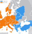
Fájl:Great Schism 1054.svg

Ennek a(z) SVG fájlnak ezen PNG formátumú előnézete: 560 × 599 képpont. További felbontások: 224 × 240 képpont | 448 × 480 képpont | 717 × 768 képpont | 957 × 1 024 képpont | 1 913 × 2 048 képpont | 1 106 × 1 184 képpont.
Eredeti fájl (SVG fájl, névlegesen 1 106 × 1 184 képpont, fájlméret: 1,2 MB)
Fájltörténet
Kattints egy időpontra, hogy a fájl akkori állapotát láthasd.
| Dátum/idő | Bélyegkép | Felbontás | Feltöltő | Megjegyzés | |
|---|---|---|---|---|---|
| aktuális | 2021. augusztus 28., 17:36 |  | 1 106 × 1 184 (1,2 MB) | Kun Kipcsak | Reverted to version as of 23:41, 17 September 2011 (UTC) Revert vandal |
| 2011. szeptember 18., 10:06 |  | 2 000 × 2 141 (643 KB) | Iaaasi | ew version of File:Great Schism 1054.svg: minor correction according to Dragan Brujić, Vodič kroz svet Vizantije, Beograd, 2004, page 51. (publishers: DINA - Beograd and RADIONICA - Pancevo) - if someone needs to check the scanned original map, please c | |
| 2011. szeptember 18., 01:41 |  | 1 106 × 1 184 (1,2 MB) | Fakirbakir | Reverted to version as of 09:30, 27 July 2010, please, Do not manipulate this map, | |
| 2011. szeptember 17., 14:38 |  | 2 000 × 2 141 (643 KB) | Iaaasi | minor correction according to Dragan Brujić, Vodič kroz svet Vizantije, Beograd, 2004, page 51. (publishers: DINA - Beograd and RADIONICA - Pancevo) - if someone needs to check the scanned original map from this historical atlas, please contact me | |
| 2010. július 27., 11:30 |  | 1 106 × 1 184 (1,2 MB) | Cassowary | {{Information |Description={{en|1=I am a map showing ''today's'' national boundaries and eastern/western allegiances in 1054.}} |Source=Derived from http://en.wikipedia.org/wiki/File:Great_Schism_1054.gif |Author=Cassowary, [[wikipedia: |
Fájlhasználat
Ezt a fájlt nem használja egyetlen lap sem.
Globális fájlhasználat
A következő wikik használják ezt a fájlt:
- Használata itt: ka.wikipedia.org

