
Fájl:Average precipitation in the lower 48 states of the USA.png

Az előnézet mérete: 800 × 538 képpont További felbontások: 320 × 215 képpont | 640 × 430 képpont | 1 024 × 689 képpont | 1 280 × 861 képpont | 2 785 × 1 873 képpont.
Eredeti fájl (2 785 × 1 873 képpont, fájlméret: 2,19 MB, MIME-típus: image/png)
|
Ez a fájl a Wikimedia Commonsból származik. Az alább látható leírás az ottani dokumentációjának másolata. A Commons projekt szabad licencű kép- és multimédiatár. Segíts te is az építésében! |
Összefoglaló
| Leírás |
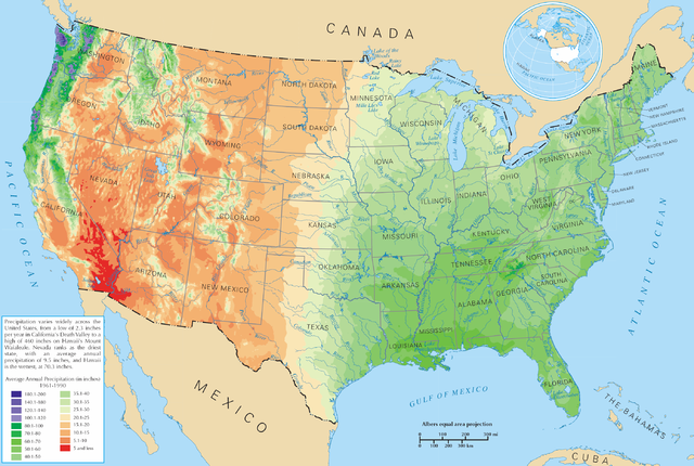
English: Average precipitation in the lower 48 states of the United States of America.
Español: Promedio de la precipitación de los 48 estados contiguos |
| Forrás | https://nationalmap.gov/small_scale/printable/climatemap.html |
| Szerző | United States Department of the Interior |
Licenc
This map was obtained from an edition of the National Atlas of the United States. Like almost all works of the U.S. federal government, works from the National Atlas are in the public domain in the United States.
Online access: NationalAtlas.gov | 1970 print edition: Library of Congress, Perry-Castañeda Library
|
Fájltörténet
Kattints egy időpontra, hogy a fájl akkori állapotát láthasd.
| Dátum/idő | Bélyegkép | Felbontás | Feltöltő | Megjegyzés | |
|---|---|---|---|---|---|
| aktuális | 2006. március 28., 23:08 | | 2 785 × 1 873 (2,19 MB) | Tom | ==Description== Average precipitation in the lower 48 states of the United States of America. ==License== {{PD-USGov-Atlas}} |
Fájlhasználat
Az alábbi lap használja ezt a fájlt:
Globális fájlhasználat
A következő wikik használják ezt a fájlt:
- Használata itt: bg.wikipedia.org
- Használata itt: cs.wikipedia.org
- Használata itt: da.wikipedia.org
- Használata itt: de.wikipedia.org
- Használata itt: en.wikipedia.org
- Használata itt: fr.wikipedia.org
- Használata itt: hak.wikipedia.org
- Használata itt: he.wikipedia.org
- Használata itt: ht.wikipedia.org
- Használata itt: hy.wikipedia.org
- Használata itt: id.wikipedia.org
- Használata itt: ja.wikipedia.org
- Használata itt: lg.wikipedia.org
- Használata itt: mg.wikipedia.org
- Használata itt: pcd.wikipedia.org
- Használata itt: pl.wikipedia.org
- Használata itt: pl.wiktionary.org
- Stany Zjednoczone
- Съединени щати
- Съединени американски щати
- Bandaríkin
- Bandaríki Norður-Ameríku
- Amerikan yhdysvallat
- Amerikka
- United States of America
- United States
- U.S.A.
- U.S.
- Stany Zjednoczone Ameryki
- Egyesült Államok
- Amerikai Egyesült Államok
- الولايات المتحدة
- Злучаныя Штаты Амерыкі
- fenua Marite
- ᐊᒥᐊᓕᑲ
- Amerikas förenta stater
- الولايات المتحدة الأمريكية
- Amerika Birləşmiş Ştatları
- Ameriketako Estatu Batuak
- Mokuʻāina-hui-ʻia
- АҚШ
A fájl globális használatának megtekintése