
Fájl:World Map 1689.JPG

Eredeti fájl (4 560 × 3 936 képpont, fájlméret: 8,59 MB, MIME-típus: image/jpeg)
|
Ez a fájl a Wikimedia Commonsból származik. Az alább látható leírás az ottani dokumentációjának másolata. A Commons projekt szabad licencű kép- és multimédiatár. Segíts te is az építésében! |
|

Ezt a képet a 2007. február 7-i nap képének választották, a következő képaláírással: Más nyelvek:
Deutsch: Eine 1689 in Amsterdam hergestellte Weltkarte. English: An old world map produced in Amsterdam in 1689. Polski: Mapa świata wyprodukowana w Amsterdamie w roku 1689. Suomi: Hollantilainen maailmankartta vuodelta 1689 Svenska: En gammal världskarta tillverkad i Amsterdam 1689. Winaray: In kahadto nga mapa han kalibutan nga ginhimo ha Amsterdam, 1689. Српски / srpski: Стара карта света направљена у Амстердаму 1689. עברית : מפת עולם משנת 1689 מאמסטרדם |
| This image was selected as a picture of the week on the Persian Wikipedia for the 21. week, 2011. |
Összefoglaló
| Leírás |
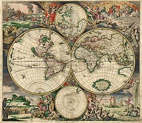
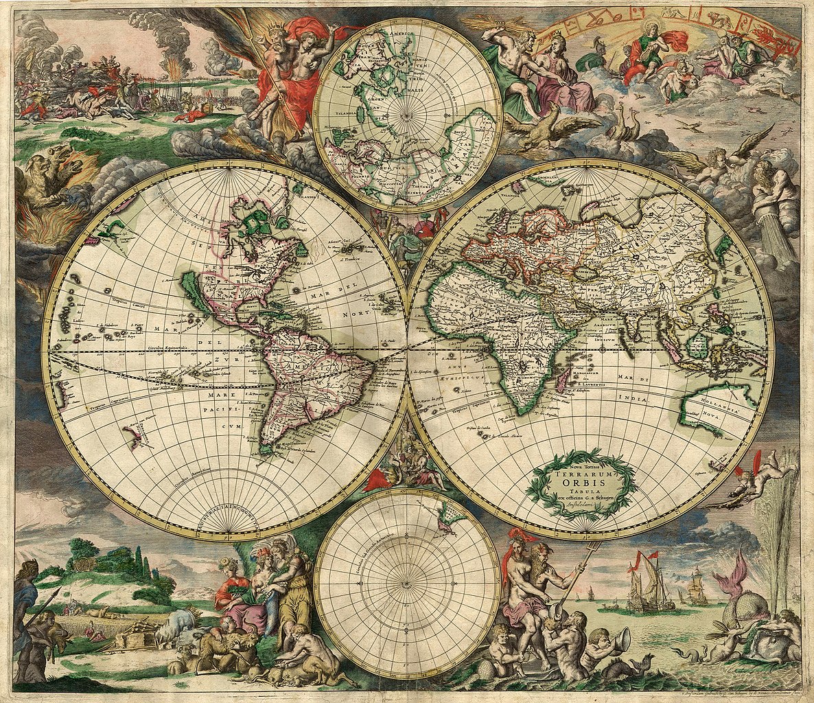
Nederlands: Nova totius terrarum orbis tabula Amstelodami, ex officina G. a Schagen (1682), t'Amsterdam Gedruckt by G. van Schagen, by de Nieuwe Haerlemmer Sluys.
English: World map - Produced in Amsterdam
First edition : 1689. Original size : 48.3 x 56.0 cm. Produced using copper engraving. Extremely rare set of maps, only known in one other example in the Amsterdam University. No copies in American libraries. In original hand color. Français : Carte du monde - Créée à Amsterdam Première édition : 1689. Taille originale : 48,3 x 56,0 cm. Eau forte. |
| Dátum | This edition 1689 |
| Forrás | This image is made up of six separate images downloaded from Helmink.com and stitched together. |
| Alkotó | |
| Engedély (Fájl újrafelhasználása) |
Public Domain |
| Georeferencing | If inappropriate please set warp_status = skip to hide. |
| Más változatok | Image:World Map 1689-smaller.jpg (smaller filesize version, easier to download) |
.JPG)
Licenc
|
Ez a mű közkincs abban az országban, ahol elkészítették, és minden olyan további államban, ahol a szerzői jogi védelmi idő a szerző élete plusz 70 év vagy kevesebb.
| |
| Megállapították, hogy ez a fájl mentes mindenféle szerzői jogi korlátozástól, beleértve az összes kapcsolódó és hozzátartozó jogot. | |
Fájltörténet
Kattints egy időpontra, hogy a fájl akkori állapotát láthasd.
| Dátum/idő | Bélyegkép | Felbontás | Feltöltő | Megjegyzés | |
|---|---|---|---|---|---|
| aktuális | 2013. szeptember 4., 02:59 | | 4 560 × 3 936 (8,59 MB) | Crisco 1492 | Reverted to version as of 12:34, 16 October 2010 |
| 2013. szeptember 4., 02:47 |  | 4 560 × 3 936 (19,56 MB) | Crisco 1492 | Reverted to version as of 01:01, 30 November 2006 Per Commons:Overwriting existing files, do not overwrite featured images | |
| 2010. október 16., 14:34 |  | 4 560 × 3 936 (8,59 MB) | Brandmeister~commonswiki | slight adjustment | |
| 2006. november 30., 03:01 |  | 4 560 × 3 936 (19,56 MB) | Tarawneh | == Summary == {{Information |Description= World map - Produced in Amsterdam<br> FIRST edition : 1689 <br> Original size : 48.3 x 56.0 cm <br> Produced using copper engraving |Source= scanned copy |Date= This edition 1689 |Author= van Schagen |Permission |
Fájlhasználat
Az alábbi lapok használják ezt a fájlt:
Globális fájlhasználat
A következő wikik használják ezt a fájlt:
- Használata itt: af.wikipedia.org
- Használata itt: ar.wikipedia.org
- Használata itt: ba.wikipedia.org
- Használata itt: bg.wikipedia.org
- Használata itt: bg.wikiquote.org
- Használata itt: bjn.wikipedia.org
- Használata itt: bn.wikipedia.org
- Használata itt: bs.wikipedia.org
- Használata itt: ca.wikipedia.org
- Használata itt: ce.wikipedia.org
- Használata itt: crh.wikipedia.org
- Használata itt: cs.wikipedia.org
- Használata itt: cv.wikipedia.org
- Használata itt: de.wikipedia.org
- Használata itt: el.wikipedia.org
A fájl globális használatának megtekintése