
Fájl:Riedl - Koenigreiche Illyrien.jpg

Eredeti fájl (7 150 × 5 808 képpont, fájlméret: 39,43 MB, MIME-típus: image/jpeg)
|
Ez a fájl a Wikimedia Commonsból származik. Az alább látható leírás az ottani dokumentációjának másolata. A Commons projekt szabad licencű kép- és multimédiatár. Segíts te is az építésében! |
Összefoglaló
| Leírás |
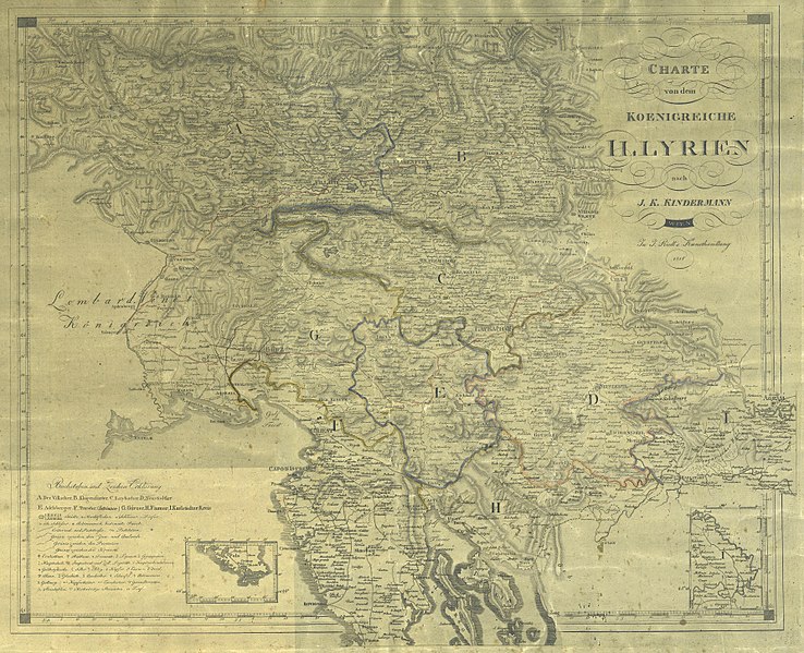
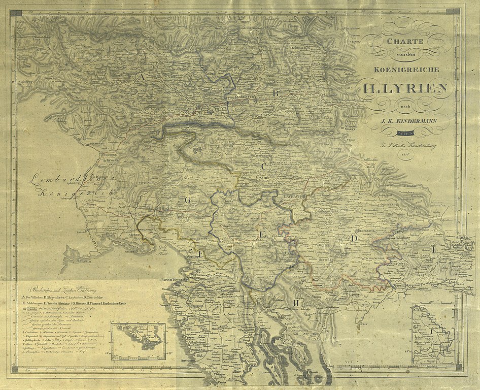
English: Map of Illyrian kingdom
Deutsch: Charte von dem Koenigreiche Illyrien
Slovenščina: Zemljevid Kraljevine Ilirije COBISS |
|||
| Dátum | ||||
| Forrás |
|
|||
| Szerző | Joseph Riedl, following the work of Joseph Karl Kindermann (1744-1801) |

Licenc
|
Ez a mű közkincs abban az országban, ahol elkészítették, és minden olyan további államban, ahol a szerzői jogi védelmi idő a szerző élete plusz 70 év vagy kevesebb.
| |
| Megállapították, hogy ez a fájl mentes mindenféle szerzői jogi korlátozástól, beleértve az összes kapcsolódó és hozzátartozó jogot. | |
Fájltörténet
Kattints egy időpontra, hogy a fájl akkori állapotát láthasd.
| Dátum/idő | Bélyegkép | Felbontás | Feltöltő | Megjegyzés | |
|---|---|---|---|---|---|
| aktuális | 2014. február 12., 12:58 | | 7 150 × 5 808 (39,43 MB) | Sporti | better res |
| 2008. október 4., 16:26 |  | 3 531 × 2 849 (3,64 MB) | Romanm | {{Information |Description={{en|1=Map of Illyrian kingdom}} {{de|1=Charte von dem Koenigreiche Illyrien}} {{sl|1=Zemljevid Kraljevine Ilirije}} |Source=[http://www.dlib.si/documents/zemljevidi/URN_NBN_SI_doc-W3Y5X59J.sid URN:NBN:SI:doc-W3Y5X59J] |Author=J |
Fájlhasználat
Az alábbi lap használja ezt a fájlt:
Globális fájlhasználat
A következő wikik használják ezt a fájlt:
- Használata itt: en.wikipedia.org
- Használata itt: it.wikipedia.org
- Használata itt: sh.wikipedia.org