
Fájl:Qin empire 210 BCE.jpg
Qin_empire_210_BCE.jpg (555 × 545 képpont, fájlméret: 298 KB, MIME-típus: image/jpeg)
|
Ez a fájl a Wikimedia Commonsból származik. Az alább látható leírás az ottani dokumentációjának másolata. A Commons projekt szabad licencű kép- és multimédiatár. Segíts te is az építésében! |
Összefoglaló
From english Wikipedia:
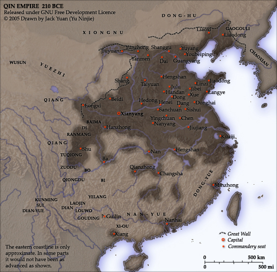
As part of his unification of China in 221 BC, Qin Shi Huang divided his empire into thirty six commanderies, each subdivided into an number of counties. The significance of the administrative reforms was its introduction of a uniformly centralised system of imperial control. The system was followed by the Han Dynasty, though with a certain degree of compromise. Thereafter, the system became the norm for later dynasties and eventually evolved into the present administrative structure of Mainland China. See: Political divisions of China.
The location of the Yellow River and commandery seats follows Tan Qixiang (ed.), Zhongguo lishi ditu (中国历史地图集), 1982. Note that the Yellow River is considerably to the north of its present flow.
The coloured territories show the approximate extent of Qin political control at the death of Qin Shi Huang in 210 BC. At that time more commanderies were added to the original thirty six, and these are also shown on the map.
Created and copyright (2005) by Yu Ninjie. Released under the GNU Free Documentation License.
Licenc

|
Ez a fájl szabadon másolható, terjeszthető és/vagy módosítható a GNU Szabad Dokumentációs Licenc feltételei alapján, az 1.2 vagy későbbi, a Free Software Foundation által publikált Nem Változtatható szakaszok, Címlapszövegek és Hátlapszövegek nélküli változat szerint. E licenc egy példánya a GNU Szabad Dokumentációs Licenc című fejezetben olvasható. |
| Ez a fájl a Creative Commons Nevezd meg! – Így add tovább! 3.0 Unported licenc alapján használható fel. | ||
| ||
| Ez a licenc a GFDL licenccsere során került a fájlra. |
Fájltörténet
Kattints egy időpontra, hogy a fájl akkori állapotát láthasd.
| Dátum/idő | Bélyegkép | Felbontás | Feltöltő | Megjegyzés | |
|---|---|---|---|---|---|
| aktuális | 2005. szeptember 2., 19:08 | | 555 × 545 (298 KB) | David.gaya | From english Wikipedia: As part of his unification of China in 221 BC, Qin Shi Huang divided his empire into thirty six commanderies, each subdivided into an number of counties. The significance of the administrative reforms wa |
Fájlhasználat
Az alábbi lap használja ezt a fájlt:
Globális fájlhasználat
A következő wikik használják ezt a fájlt:
- Használata itt: als.wikipedia.org
- Használata itt: ar.wikipedia.org
- Használata itt: azb.wikipedia.org
- Használata itt: ba.wikipedia.org
- Használata itt: be.wikipedia.org
- Használata itt: bn.wikipedia.org
- Használata itt: ce.wikipedia.org
- Használata itt: de.wikipedia.org
- Használata itt: el.wikipedia.org
- Használata itt: en.wikipedia.org
- Használata itt: en.wikiversity.org
- Használata itt: es.wikipedia.org
- Használata itt: et.wikipedia.org
- Használata itt: fi.wikipedia.org
- Használata itt: fi.wikibooks.org
- Használata itt: frr.wikipedia.org
- Használata itt: fr.wikipedia.org
- Használata itt: fr.wikiversity.org
- Használata itt: he.wikipedia.org
- Használata itt: hy.wikipedia.org
- Használata itt: id.wikipedia.org
- Használata itt: kk.wikipedia.org
- Használata itt: ko.wikipedia.org
- Használata itt: la.wikipedia.org
- Használata itt: lt.wikipedia.org
- Használata itt: ml.wikipedia.org
- Használata itt: nl.wikipedia.org
- Használata itt: nn.wikipedia.org
- Használata itt: no.wikipedia.org
- Használata itt: pnb.wikipedia.org
- Használata itt: pt.wikibooks.org
- Használata itt: ro.wikipedia.org
- Használata itt: ru.wikipedia.org
A fájl globális használatának megtekintése