
Fájl:Noord-Brabant position.svg

Ennek a(z) SVG fájlnak ezen PNG formátumú előnézete: 200 × 236 képpont. További felbontások: 203 × 240 képpont | 407 × 480 képpont | 651 × 768 képpont | 868 × 1 024 képpont | 1 736 × 2 048 képpont.
Eredeti fájl (SVG fájl, névlegesen 200 × 236 képpont, fájlméret: 158 KB)
|
Ez a fájl a Wikimedia Commonsból származik. Az alább látható leírás az ottani dokumentációjának másolata. A Commons projekt szabad licencű kép- és multimédiatár. Segíts te is az építésében! |
Összefoglaló
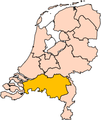
| Leírás | Location of the province of Noord-Brabant (North Brabant) in the Netherlands. |
| Dátum | |
| Forrás | Own work, based on freely available GIS data |
| Szerző | User:Mtcv |
| Engedély (Fájl újrafelhasználása) |
Data: attribution required; my work: PD |
| Más változatok | I attempted to make an svg version of Image:Noord Brabant-Position.png (with less simplified boundaries) |
Clickable version

Licenc

|
A fájl szerzői jogainak tulajdonosa, Centraal Bureau voor de Statistiek engedélyezi a mű bármilyen céllal történő használatát azzal a feltétellel, hogy a szerzői jog tulajdonosa megfelelően fel van tüntetve. Az újraterjesztés, származékos művek, kereskedelmi és bármilyen egyéb célú használat megengedett. |
Így nevezd meg:
|
| Képjegyzetek | Ehhez a képhez képjegyzetek tartoznak: Képjegyzetek megtekintése a Commonson |


Fájltörténet
Kattints egy időpontra, hogy a fájl akkori állapotát láthasd.
| Dátum/idő | Bélyegkép | Felbontás | Feltöltő | Megjegyzés | |
|---|---|---|---|---|---|
| aktuális | 2019. március 2., 19:20 | | 200 × 236 (158 KB) | Thayts | update |
| 2006. október 3., 02:49 |  | 200 × 236 (158 KB) | Mtcv | {{Information| |Description=Location of the province of Noord-Holland (North Holland) in the Netherlands. |Source=Own work, based on freely available GIS data |Date=2006-10-03 |Author=User:Mtcv |Permission=Data: attribution required; my work: PD |othe |
Fájlhasználat
Az alábbi lapok használják ezt a fájlt:
Globális fájlhasználat
A következő wikik használják ezt a fájlt:
- Használata itt: ar.wikipedia.org
- شمال بربنت
- آيندهوفن
- بريدا
- بارله ناساو
- تيلبورخ
- سيرتوخيمبوس
- قالب:بلديات شمال برابنت
- آلبورخ
- ألفن- كام
- أستن
- بيرخ آيك
- فيلدهوفن
- بيرخن أوب زووم
- بيرنهيزه
- بيست (هولندا)
- بلادل
- بوكل
- بوكسمير
- بوكستل
- كرانندونك
- كاوك
- دورنه
- دونجن
- دريميلين
- إيرسل
- إيتن- لور
- خيرتراودنبيرخ
- خيلدروب- ميرلو
- خيميرت- باكل
- خيلزه آن راين
- خورلا
- خرافه (هولندا)
- هارن (شمال برابنت)
- هالدربيرخه
- هيزه- لينده
- هيلموند
- هوسدن
- هيلفارينبيك
- لاربيك
- لانديرد
- لوب أوب زند
- مل آن سينت هوبرت
- موردايك
- نونن (خيرفن آن نيدرفيتن)
- أويرشخوت
- أويسترفايك
- أوسترهاوت
- أوس (هولندا)
- روسل- دي ميردن
- روسيندال
A fájl globális használatának megtekintése