
Fájl:Niger - Location Map (2011) - NER - UNOCHA.svg

Eredeti fájl (SVG fájl, névlegesen 254 × 254 képpont, fájlméret: 342 KB)
|
Ez a fájl a Wikimedia Commonsból származik. Az alább látható leírás az ottani dokumentációjának másolata. A Commons projekt szabad licencű kép- és multimédiatár. Segíts te is az építésében! |
_-_NER_-_UNOCHA.svg)
Összefoglaló
| Leírás |
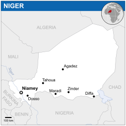
English: Locator map of Niger. |
| Dátum | |
| Forrás |
English: Niger Locator Map (ReliefWeb) |
| Szerző | |
| SVG kód | Ez vektorgrafikus kép Inkscape segítségével készült. |
Licenc
- A következőket teheted a művel:
- megoszthatod – szabadon másolhatod, terjesztheted, bemutathatod és előadhatod a művet
- feldolgozhatod – származékos műveket hozhatsz létre
- Az alábbi feltételekkel:
- Nevezd meg! – A szerzőt megfelelően fel kell tüntetned, hivatkozást kell létrehoznod a licencre és jelezned kell, ha a művön változtatást hajtottál végre. Ezt bármilyen észszerű módon megteheted, kivéve oly módon, ami azt sugallná hogy a jogosult támogat téged vagy a felhasználásod körülményeit.
 This map is part of a collection of 216 free country maps, created by the UN Office for the Coordination of Humanitarian Affairs (OCHA), to be used in print, web or broadcast products.
The ReliefWeb Location Maps released here are maps that highlight a country, its capital, major populated places and the surrounding regions. Attribution Requirements
Using the map without modifications: ensure that the sources and the disclaimer are below the map. Credit as follows: "Credit: OCHA". For use with alteration: remove the OCHA logo and disclaimer following any modification to the map, but keep the data sources as mentioned below the map. Credit the modified map as follows: "Based on OCHA map". You are responsible for the content of your map. We are keen to receive your feedback and hear how you used OCHA's maps. We would be grateful if you would notify us by e-mail and share your work with us. UN Disclaimer
The designations employed and the presentation of material of this map do not imply the expression of any opinion whatsoever on the part of the Secretariat of the United Nations concerning the legal status of any country, territory, city or area or of its authorities or concerning the delimitation of its frontiers or boundaries. |
Fájltörténet
Kattints egy időpontra, hogy a fájl akkori állapotát láthasd.
| Dátum/idő | Bélyegkép | Felbontás | Feltöltő | Megjegyzés | |
|---|---|---|---|---|---|
| aktuális | 2014. november 18., 05:33 | | 254 × 254 (342 KB) | Pharos | try without logo for now |
| 2014. május 8., 02:05 |  | 254 × 254 (338 KB) | UN OCHA maps bot | == {{int:filedesc}} == {{Information |description={{en|1=Locator map of Niger.}} |date=2011 |source={{en|1=[http://reliefweb.int/map/niger/niger-location-map-2011 Niger Locator Map (ReliefWeb)]}} |author={{en|1=[[w:en:United Nations Offi... |
Fájlhasználat
Az alábbi lap használja ezt a fájlt:
Globális fájlhasználat
A következő wikik használják ezt a fájlt:
- Használata itt: azb.wikipedia.org
- Használata itt: bh.wikipedia.org
- Használata itt: bn.wikipedia.org
- Használata itt: es.wikipedia.org
- Használata itt: id.wikipedia.org
- Használata itt: ilo.wikipedia.org
- Használata itt: lb.wikipedia.org
- Használata itt: ms.wikipedia.org
- Használata itt: ne.wikipedia.org
- Használata itt: pl.wikipedia.org
- Használata itt: sco.wikipedia.org
- Használata itt: sd.wikipedia.org
- Használata itt: te.wikipedia.org
_-_NER_-_UNOCHA.svg)