
Fájl:Hanstholmen-map.png

Eredeti fájl (2 260 × 1 557 képpont, fájlméret: 1,14 MB, MIME-típus: image/png)
|
Ez a fájl a Wikimedia Commonsból származik. Az alább látható leírás az ottani dokumentációjának másolata. A Commons projekt szabad licencű kép- és multimédiatár. Segíts te is az építésében! |
Összefoglaló
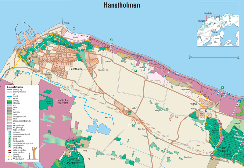
Source: http://en.wikipedia.org/wiki/Image:Hanstholmen-map.png
A detailed map of Hanstholm. From the brochure "Vandreture nr. 118. Hanstholmen", updated January 2005, published by the Danish Forest and Nature Agency. The dashed lines indicate a very steep slope, the former coastline.
Licenc
Under the case number "J.nr. SN 2001-0650-0003", where Lars Dybdahl requested permission to use this map with Wikipedia, the case was handled by the responsible person Pia Bøttiger Andersen from the Danish Ministry of the Environment, on the date 2005-12-20. The response was, that the Danish Forest and Nature Agency has permitted the use of this map for general use, as long as a reference to the source is given. This is an example of such a reference is in Danish:
- Fra Skov- og Naturstyrelsens folder "Vandreture nr. 118. Hanstholmen (opdateret januar 2005).
This translates into:
- From the Danish Forest and Nature Agency brochure "Vandreture nr. 118. Hanstholmen" (updated January 2005)
The official homepage of the agency is: www.skovognatur.dk Official email address of the agency is: sns@sns.dk
- A következőket teheted a művel:
- megoszthatod – szabadon másolhatod, terjesztheted, bemutathatod és előadhatod a művet
- feldolgozhatod – származékos műveket hozhatsz létre
- Az alábbi feltételekkel:
- Nevezd meg! – A szerzőt megfelelően fel kell tüntetned, hivatkozást kell létrehoznod a licencre és jelezned kell, ha a művön változtatást hajtottál végre. Ezt bármilyen észszerű módon megteheted, kivéve oly módon, ami azt sugallná hogy a jogosult támogat téged vagy a felhasználásod körülményeit.
- Így add tovább! – Ha megváltoztatod, átalakítod, feldolgozod ezt a művet, a közreműködésedet csak az eredetivel megegyező vagy hasonló licenc alatt terjesztheted.
Fájltörténet
Kattints egy időpontra, hogy a fájl akkori állapotát láthasd.
| Dátum/idő | Bélyegkép | Felbontás | Feltöltő | Megjegyzés | |
|---|---|---|---|---|---|
| aktuális | 2006. június 27., 19:45 | | 2 260 × 1 557 (1,14 MB) | Igiveup | == Summary == Source: http://en.wikipedia.org/wiki/Image:Hanstholmen-map.png A detailed map of Hanstholm. From the brochure "Vandreture nr. 118. Hanstholmen", updated January 2005, published by [http://www.sns.dk/ the Danish Forest and Nature Agency]. T |
Fájlhasználat
Az alábbi lap használja ezt a fájlt:
Globális fájlhasználat
A következő wikik használják ezt a fájlt: