
Fájl:Europe 814.png

Az előnézet mérete: 777 × 600 képpont További felbontások: 311 × 240 képpont | 622 × 480 képpont | 995 × 768 képpont | 1 280 × 988 képpont | 1 393 × 1 075 képpont.
Eredeti fájl (1 393 × 1 075 képpont, fájlméret: 169 KB, MIME-típus: image/png)
|
Ez a fájl a Wikimedia Commonsból származik. Az alább látható leírás az ottani dokumentációjának másolata. A Commons projekt szabad licencű kép- és multimédiatár. Segíts te is az építésében! |

Összefoglaló
| Leírás |
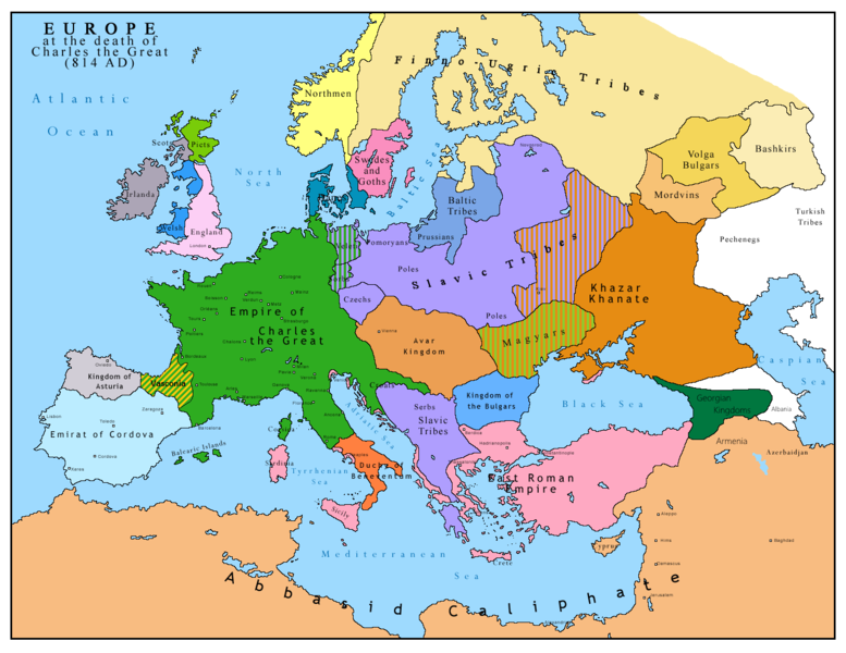
English: Map of Europe after the death of Charles the Great (814 AD). Original map made by Charles Colbeck, The Public Schools Historical Atlas (1905). |
|||
| Dátum | 2009-04-15. Source date: 1905 by Longmans, Green; New York, London, Bombay 1905. | |||
| Forrás | A feltöltő saját munkája, a következőn alapul: Europe 814.jpg | |||
| Szerző | Bukkia (vitalap · szerkesztései) | |||
| Más változatok |
|


Licenc
| Én, a szerző, ezt a művemet ezennel közkinccsé nyilvánítom. Ez a világ minden részén érvényes. Egyes országokban ez jogilag nem lehetséges. Ha így van, akkor: Jogot adok bárkinek, hogy bármilyen célból, feltétel nélkül használhassa ezt a fájlt, kivéve a törvény által kötelezően előírt feltételeket. |
_en.png)
.png)
.jpg)
Fájltörténet
Kattints egy időpontra, hogy a fájl akkori állapotát láthasd.
| Dátum/idő | Bélyegkép | Felbontás | Feltöltő | Megjegyzés | |
|---|---|---|---|---|---|
| aktuális | 2023. április 26., 13:09 | | 1 393 × 1 075 (169 KB) | OrionNimrod | Reverted to version as of 13:52, 23 December 2015 (UTC) restore |
| 2019. május 2., 18:09 |  | 1 370 × 1 047 (124 KB) | Julieta39 | Slavs also in the Avars and Bulgars kingdoms | |
| 2015. december 23., 15:52 |  | 1 393 × 1 075 (169 KB) | Ercwlff | at that time armenia was already part of Arab caliphate.. and there were several Georgian kingdoms or principalities in the north of them | |
| 2015. június 8., 15:52 |  | 1 393 × 1 075 (157 KB) | Zorion | Vasconia in rebellion | |
| 2015. május 28., 19:49 |  | 1 393 × 1 075 (156 KB) | Zorion | From 812 to 824, Vasconia was ruled by Vascons (sourced can be found anywhere in spanish, basque or french). This map was wrong for that specific year. Seems that historian wanted to credit a famous king but, he was dead when Wasconia got back under th... | |
| 2014. augusztus 24., 17:58 |  | 1 393 × 1 075 (230 KB) | Martin H. | Reverted to version as of 14:53, 31 January 2010: File is consistent with its source file File:Europe 814.jpg; change conflicts with en:Duchy_of_Vasconia#Carolingian duchy (769–864) | |
| 2014. augusztus 24., 16:42 |  | 1 393 × 1 075 (156 KB) | Zorion | Vasconia was independant from frankish kingdom until 824 | |
| 2010. január 31., 16:53 |  | 1 393 × 1 075 (230 KB) | Bukkia | == {{int:filedesc}} == {{Information |Description={{it|1=Mappa dell'Europa alla morte di Carlo Magno (814 d.C.)}} {{en|1=Map of Europe after the death of Charles the Great (814 AD, in Italian)}} |Source=Based on File:Europe 814.jpg |Author=[[user:Buk |
Fájlhasználat
Az alábbi lap használja ezt a fájlt:
Globális fájlhasználat
A következő wikik használják ezt a fájlt:
- Használata itt: arz.wikipedia.org
- Használata itt: bo.wikipedia.org
- Használata itt: da.wikipedia.org
- Használata itt: de.wikipedia.org
- Használata itt: el.wikipedia.org
- Használata itt: en.wikipedia.org
- Használata itt: es.wikipedia.org
- Használata itt: fa.wikipedia.org
- Használata itt: fr.wikipedia.org
- Használata itt: gl.wikipedia.org
- Használata itt: he.wikipedia.org
- Használata itt: hy.wikipedia.org
- Használata itt: id.wikipedia.org
- Használata itt: it.wikipedia.org
- Használata itt: ko.wikipedia.org
- Használata itt: lmo.wikipedia.org
- Használata itt: lv.wikipedia.org
- Használata itt: mk.wikipedia.org
- Használata itt: pl.wikipedia.org
- Használata itt: ro.wikipedia.org
- Használata itt: sh.wikipedia.org
- Használata itt: sr.wikipedia.org
- Használata itt: sw.wikipedia.org
- Használata itt: uk.wikipedia.org