
Fájl:Europe 1914 Shepherd.jpg
Eredeti fájl (1 789 × 1 465 képpont, fájlméret: 3,78 MB, MIME-típus: image/jpeg)
|
Ez a fájl a Wikimedia Commonsból származik. Az alább látható leírás az ottani dokumentációjának másolata. A Commons projekt szabad licencű kép- és multimédiatár. Segíts te is az építésében! |
Összefoglaló
| Leírás |
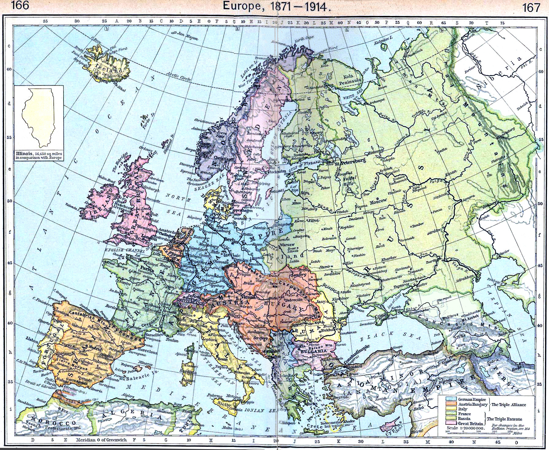
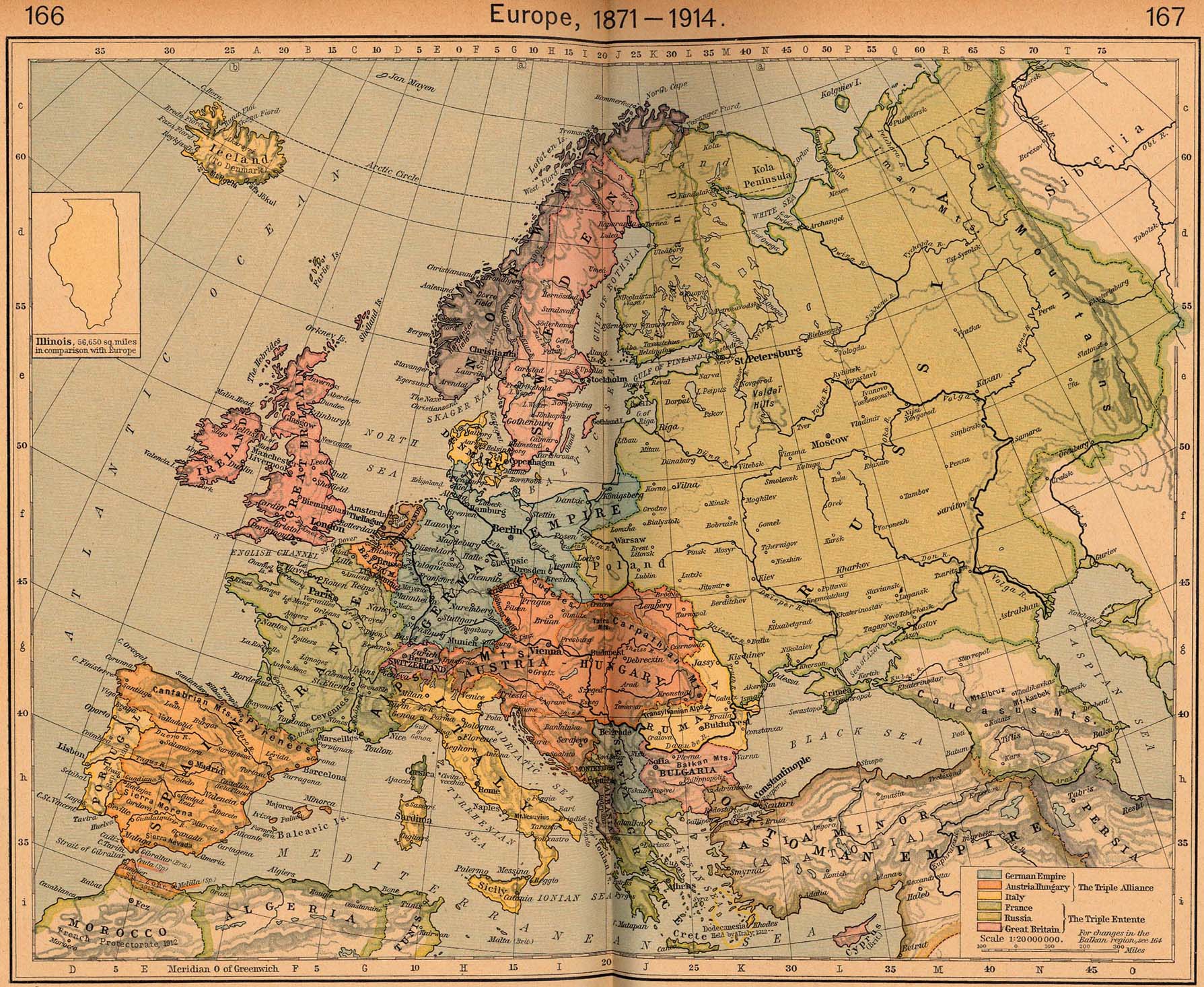
English: Map of Europe in 1914 |
||||||||||||||||||||||
| Dátum | |||||||||||||||||||||||
| Forrás | http://www.lib.utexas.edu/maps/historical/shepherd/europe_1871_1914.jpg | ||||||||||||||||||||||
| Szerző |
|
||||||||||||||||||||||
This is from the 1926 edition of the "Historical Atlas" by William R. Shepherd published by the Henry Holt and Company, New York. It may have been first published earlier in previous editions. The image is from the University of Texas Perry-Castañeda Library Map Collection.
Licenc
|
Ez a mű közkincs abban az országban, ahol elkészítették, és minden olyan további államban, ahol a szerzői jogi védelmi idő a szerző élete plusz 70 év vagy kevesebb.
| |
| Megállapították, hogy ez a fájl mentes mindenféle szerzői jogi korlátozástól, beleértve az összes kapcsolódó és hozzátartozó jogot. | |
_en.png)
.png)
.jpg)
Fájltörténet
Kattints egy időpontra, hogy a fájl akkori állapotát láthasd.
| Dátum/idő | Bélyegkép | Felbontás | Feltöltő | Megjegyzés | |
|---|---|---|---|---|---|
| aktuális | 2022. szeptember 20., 14:15 | | 1 789 × 1 465 (3,78 MB) | Рагин1987 | Small correction |
| 2012. március 21., 11:17 |  | 1 789 × 1 465 (2,73 MB) | Phoenix7777 | Reduced creases | |
| 2012. március 20., 15:55 |  | 1 789 × 1 465 (2,85 MB) | 1Veertje | more exposure on the fold | |
| 2011. február 23., 02:48 |  | 1 789 × 1 465 (2,84 MB) | Pearts | sides lined up, page bends made a little less visible, vibrance reduced a little | |
| 2010. október 3., 18:26 |  | 1 789 × 1 465 (1,39 MB) | PawełMM | flattened & whitened | |
| 2010. július 6., 16:49 |  | 1 789 × 1 465 (623 KB) | Yebellz | Whitened Version | |
| 2010. július 6., 16:41 |  | 1 789 × 1 465 (604 KB) | Yebellz | {{Information |Description={{en|1=Map of Europe in 1914}} |Source=http://www.lib.utexas.edu/maps/historical/shepherd/europe_1871_1914.jpg |Author=William R. Shepherd |Date=1926 |Permission= |other_versions= }} This is from the 1926 edition of the "Histori |
Fájlhasználat
Az alábbi lapok használják ezt a fájlt:
Globális fájlhasználat
A következő wikik használják ezt a fájlt:
- Használata itt: en.wikipedia.org
- Használata itt: hy.wikipedia.org
- Használata itt: nl.wikipedia.org
- Használata itt: pl.wikipedia.org
- Használata itt: pt.wikipedia.org
- Használata itt: ru.wikipedia.org