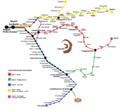
Fájl:Circumvesuviana maps.png

Az előnézet mérete: 659 × 600 képpont További felbontások: 264 × 240 képpont | 528 × 480 képpont | 844 × 768 képpont | 1 208 × 1 099 képpont.
Eredeti fájl (1 208 × 1 099 képpont, fájlméret: 326 KB, MIME-típus: image/png)
Fájltörténet
Kattints egy időpontra, hogy a fájl akkori állapotát láthasd.
| Dátum/idő | Bélyegkép | Felbontás | Feltöltő | Megjegyzés | |
|---|---|---|---|---|---|
| aktuális | 2012. november 27., 00:25 |  | 1 208 × 1 099 (326 KB) | GerontaSebezio | User created page with UploadWizard |
Fájlhasználat
Az alábbi lap használja ezt a fájlt:
Globális fájlhasználat
A következő wikik használják ezt a fájlt:
- Használata itt: ca.wikipedia.org
- Használata itt: de.wikipedia.org
- Használata itt: de.wikivoyage.org
- Használata itt: en.wikipedia.org
- Használata itt: en.wikivoyage.org
- Használata itt: fr.wikipedia.org
- Használata itt: it.wikipedia.org
- Használata itt: ja.wikipedia.org
- Használata itt: lmo.wikipedia.org
- Használata itt: nl.wikipedia.org
- Használata itt: pl.wikipedia.org
- Használata itt: ru.wikipedia.org
- Használata itt: www.wikidata.org
