
Fájl:CastelloPlanOriginal.jpg
Eredeti fájl (2 100 × 1 398 képpont, fájlméret: 3,28 MB, MIME-típus: image/jpeg)
|
Ez a fájl a Wikimedia Commonsból származik. Az alább látható leírás az ottani dokumentációjának másolata. A Commons projekt szabad licencű kép- és multimédiatár. Segíts te is az építésében! |
Összefoglaló
| Leírás |
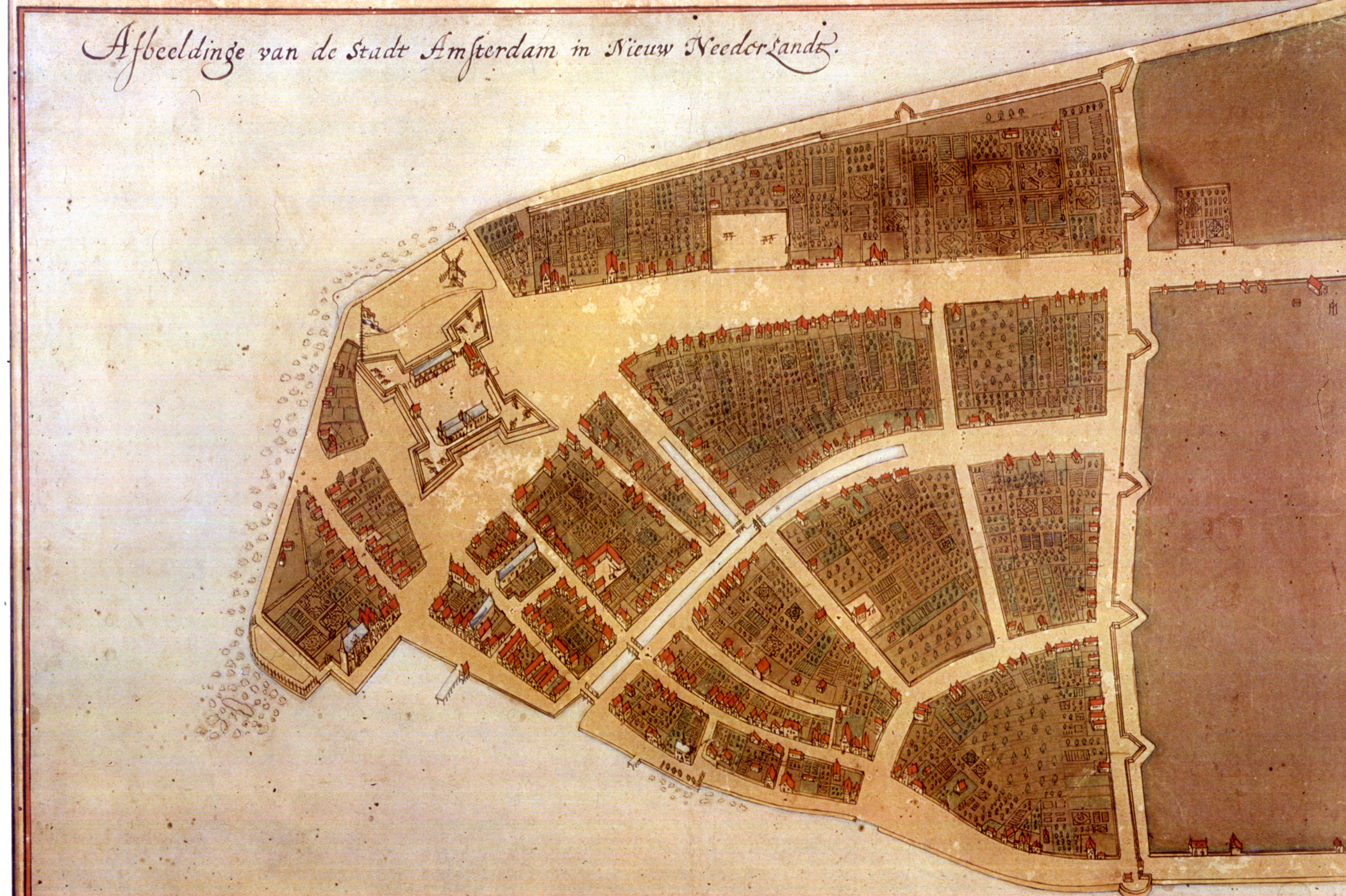
The original en:Castello Plan. Full size photograph of manuscript map in the Biblioteca Medicea-Laurenziana of Florence, Italy. The Castello plan is the earliest known plan of New Amsterdam (not Amsterdam, as you can see on the picture), and the only one dating from the Dutch period. The text at the top of the image states: "Image of the city Amsterdam in New Netherland". |
| Dátum | |
| Forrás | New York Public Library, Digital Gallery. Digital ID: 54682, Digital Record ID: 118555. |
| Szerző | Jacques Cortelyou, General Governor of Nieuw Amsterdam at that time. |
| Más változatok |
_Castello_Plan_1660.jpg)  |
Licenc
|
Ez egy kétdimenziós, közkincs mű hű fényképe. Maga a mű a következő okból számít közkincsnek:
A Wikimédia Alapítvány hivatalos álláspontja szerint „kétdimenziós közkincs művek hű reprodukciói közkincsnek számítanak”.
Ez a fénykép ezért szintén közkincsnek számít. Más jogrendszerekben ennek a műnek az újrafelhasználása korlátozott lehet; lásd a Commons:Reuse of PD-Art photographs lapot a részletekért. | ||||
| This image is available from the New York Public Library's Digital Library under the strucID 118555 This tag does not indicate the copyright status of the attached work. A normal copyright tag is still required. See Commons:Licensing for more information. |
.
Fájltörténet
Kattints egy időpontra, hogy a fájl akkori állapotát láthasd.
| Dátum/idő | Bélyegkép | Felbontás | Feltöltő | Megjegyzés | |
|---|---|---|---|---|---|
| aktuális | 2012. április 25., 23:16 | | 2 100 × 1 398 (3,28 MB) | Fentener van Vlissingen | higher resolution |
| 2010. július 9., 19:05 |  | 1 200 × 905 (180 KB) | JuTa | higher resolution from de:Datei:Manhattan1.jpg uploaded by de:user:Nikater at 2006-07-13 14:31:26 local time | |
| 2007. október 13., 01:07 |  | 760 × 569 (355 KB) | Hu Totya | {{Information |Description=The original en:Castello plan. Full size photograph of manuscript map in the Biblioteca Medicea-Laurenziana of Florence, Italy. The Castello plan is the earliest known plan of New Amsterdam, and the only one dating from the |
Fájlhasználat
Ezt a fájlt nem használja egyetlen lap sem.
Globális fájlhasználat
A következő wikik használják ezt a fájlt:
- Használata itt: ar.wikipedia.org
- Használata itt: arz.wikipedia.org
- Használata itt: azb.wikipedia.org
- Használata itt: cdo.wikipedia.org
- Használata itt: en.wikipedia.org
- Használata itt: fa.wikipedia.org