
Fájl:Carnegie Free Library, 300 East South Street, Union (Union County, South Carolina).jpg

Eredeti fájl (4 611 × 3 202 képpont, fájlméret: 1,48 MB, MIME-típus: image/jpeg)
|
Ez a fájl a Wikimedia Commonsból származik. Az alább látható leírás az ottani dokumentációjának másolata. A Commons projekt szabad licencű kép- és multimédiatár. Segíts te is az építésében! |
|
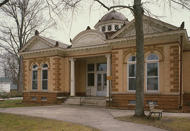
This is an image of a place or building that is listed on the National Register of Historic Places in the United States of America. Its reference number is 83002211. |
| Leírás |
English: Front of the Union Carnegie Free Library, located at 300 E. South Street in Union, South Carolina, United States. Built in 1905, it is part of the South Street-South Church Street Historic District, a historic district that is listed on the National Register of Historic Places. |
|||||||||||||||||||||||||
| Dátum | ||||||||||||||||||||||||||
| Forrás |
Library of Congress, Prints and Photograph Division
|
|||||||||||||||||||||||||
| Szerző |
|
|||||||||||||||||||||||||
| Engedély (Fájl újrafelhasználása) |
|
|||||||||||||||||||||||||


.jpg)
| Fényképező elhelyezkedése | | További képek erről a helyről: OpenStreetMap |
|---|
.jpg¶ms=034.713333_N_-081.620667_E_globe:Earth_type:camera__&language=hu)
Fájltörténet
Kattints egy időpontra, hogy a fájl akkori állapotát láthasd.
| Dátum/idő | Bélyegkép | Felbontás | Feltöltő | Megjegyzés | |
|---|---|---|---|---|---|
| aktuális | 2010. február 11., 02:09 | | 4 611 × 3 202 (1,48 MB) | Nyttend | Much higher resolution |
| 2009. március 21., 13:40 |  | 585 × 409 (96 KB) | KudzuVine | {{Information |Description={{en|1=Carnegie Free Library, 300 East South Street, Union (Union County, South Carolina) {{PD-USGov-Interior-HABS}} {{HABS| SC,44-UNI,1-13}}}} |Source=http://memory.loc.gov/cgi-bin/displayPhoto.pl?path=/pnp/habshaer/sc/sc0700/s |
Fájlhasználat
Az alábbi lap használja ezt a fájlt:
Globális fájlhasználat
A következő wikik használják ezt a fájlt:
- Használata itt: ar.wikipedia.org
- Használata itt: ceb.wikipedia.org
- Használata itt: ce.wikipedia.org
- Használata itt: cy.wikipedia.org
- Használata itt: en.wikipedia.org
- Használata itt: es.wikipedia.org
- Használata itt: fr.wikipedia.org
- Használata itt: ga.wikipedia.org
- Használata itt: hy.wikipedia.org
- Használata itt: it.wikipedia.org
- Használata itt: ko.wikipedia.org
- Használata itt: no.wikipedia.org
- Használata itt: pl.wikipedia.org
- Használata itt: pt.wikipedia.org
- Használata itt: ro.wikipedia.org
- Használata itt: ru.wikipedia.org
- Használata itt: simple.wikipedia.org
- Használata itt: sr.wikipedia.org
- Használata itt: sv.wikipedia.org
- Használata itt: tr.wikipedia.org
- Használata itt: tt.wikipedia.org
- Használata itt: ur.wikipedia.org
- Használata itt: www.wikidata.org
.jpg)