
Fájl:Bremen territory map 1806.jpg
Az előnézet mérete: 800 × 564 képpont További felbontások: 320 × 226 képpont | 640 × 452 képpont | 978 × 690 képpont.
Eredeti fájl (978 × 690 képpont, fájlméret: 116 KB, MIME-típus: image/jpeg)
|
Ez a fájl a Wikimedia Commonsból származik. Az alább látható leírás az ottani dokumentációjának másolata. A Commons projekt szabad licencű kép- és multimédiatár. Segíts te is az építésében! |
Összefoglaló
| Leírás |
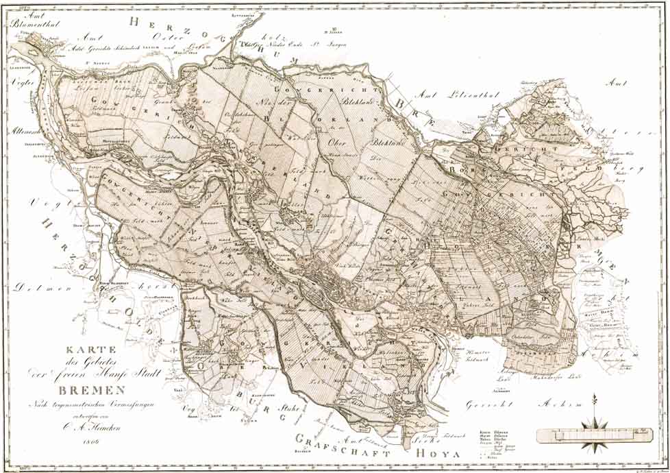
Deutsch: Originaltitel: „KARTE / des Gebietes / Der freien Hanſe Stadt / BREMEN / Nach trigonometrischen Vermessungen / entworfen von / C. A. Heineken / 1806“ – Maßstab ca. 1:42.000 – Es handelt sich quasi um die 2. Auflage der Übersichtskarte der ersten genauen Landesaufnahme des bremischen Staatsgebietes. Die erste war, ebenfalls unter der Autorschaft Heinekens, 1798 erschienen und nun durch die Gebietsgewinne auf dem Reichsdeputationshauptschluss 1803 nicht mehr aktuell. Erst am 20. November 1806 kam Bremen unter französische Besatzung. Am 18. Dezember 1810 wurde die alte Verfassung aufgehoben und 1. Januar 1811 Bremen von Frankreich annektiert. Am 25. Oktober 1813 endete die französische Besatzung, und am 6. November 1813 wurde die Freie Hansestadt Bremen in den Grenzen von 1803 und mit der bis 1810 gültigen Verfassung wiederhergestellt. English: Translation of the title: "Map of the territory of the Free Hanseatic city of Bremen", designed by C. A. Heineken according to a trigonometric survey" – scale about 1:42,000 – This map is basically a revised edition of the map published by Keineken in 1798, which had become outdated due to the enlargement of the territory of Bremen following the German mediatization in 1803. |
| Dátum | |
| Forrás | http://www.ra.se/KRA/0406fg.html |
| Szerző | C. A. Heineken |
| Más változatok | File:Karte_des_Gebietes_der_freien_Hanse_Stadt_Bremen_1806.jpg (better resolution: 4,045 × 2,823 px) |
Licenc
|
Ez a mű közkincs abban az országban, ahol elkészítették, és minden olyan további államban, ahol a szerzői jogi védelmi idő a szerző élete plusz 100 év vagy kevesebb. | |
| Megállapították, hogy ez a fájl mentes mindenféle szerzői jogi korlátozástól, beleértve az összes kapcsolódó és hozzátartozó jogot. | |
Fájltörténet
Kattints egy időpontra, hogy a fájl akkori állapotát láthasd.
| Dátum/idő | Bélyegkép | Felbontás | Feltöltő | Megjegyzés | |
|---|---|---|---|---|---|
| aktuális | 2006. április 19., 08:17 | | 978 × 690 (116 KB) | Tarawneh | {{Information| |Description=Bremen Old Map |Source=http://www.ra.se/KRA/0406fg.html |Date=1806 |Author= |Permission={{PD-old}} |other_versions= }} Category:Old Maps, Bremen, Germany |
Fájlhasználat
Az alábbi lap használja ezt a fájlt:
Globális fájlhasználat
A következő wikik használják ezt a fájlt:
- Használata itt: de.wikipedia.org
- Használata itt: ru.wikipedia.org