
Fájl:1960 Electoral Map.png

Az előnézet mérete: 800 × 430 képpont További felbontások: 320 × 172 képpont | 640 × 344 képpont | 1 182 × 635 képpont.
Eredeti fájl (1 182 × 635 képpont, fájlméret: 179 KB, MIME-típus: image/png)
|
Ez a fájl a Wikimedia Commonsból származik. Az alább látható leírás az ottani dokumentációjának másolata. A Commons projekt szabad licencű kép- és multimédiatár. Segíts te is az építésében! |
| U.S. presidential election maps from the National Atlas of the United States |
| See also: SVG maps |
| 1789 · 1792 · 1796 · 1800 · 1804 · 1808 · 1812 · 1816 · 1820 · 1824 · 1828 · 1832 · 1836 · 1840 · 1844 · 1848 · 1852 · 1856 · 1860 · 1864 · 1868 · 1872 · 1876 · 1880 · 1884 · 1888 · 1892 · 1896 · 1900 · 1904 · 1908 · 1912 · 1916 · 1920 · 1924 · 1928 · 1932 · 1936 · 1940 · 1944 · 1948 · 1952 · 1956 · 1960 · 1964 · 1968 · 1972 · 1976 · 1980 · 1984 · 1988 · 1992 · 1996 · 2000 · 2004 |
Összefoglaló
| Leírás |
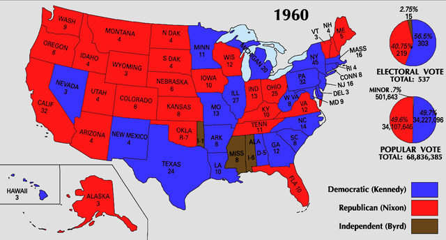
English: 1960 Electoral College Map |
| Forrás | https://nationalmap.gov/small_scale/printable/elections.html |
| Szerző | United States Geological Survey |
Licenc
This map was obtained from an edition of the National Atlas of the United States. Like almost all works of the U.S. federal government, works from the National Atlas are in the public domain in the United States.
Online access: NationalAtlas.gov | 1970 print edition: Library of Congress, Perry-Castañeda Library
|
Fájltörténet
Kattints egy időpontra, hogy a fájl akkori állapotát láthasd.
| Dátum/idő | Bélyegkép | Felbontás | Feltöltő | Megjegyzés | |
|---|---|---|---|---|---|
| aktuális | 2008. június 26., 00:16 | | 1 182 × 635 (179 KB) | Tallicfan20 | |
| 2008. június 25., 23:44 |  | 1 182 × 635 (179 KB) | Tallicfan20 | better coloring | |
| 2008. május 30., 08:36 |  | 1 182 × 635 (164 KB) | Tallicfan20 | ||
| 2008. május 24., 19:31 |  | 1 182 × 635 (165 KB) | Tallicfan20 | better coloring | |
| 2008. május 16., 19:38 |  | 1 182 × 635 (109 KB) | Tallicfan20 | {{Information |Description=1960 Electoral College Map |Source=National Atlas |Date=5/16/2008 |Author=National Atlas |Permission=PD |other_versions= }} {{PD-USGov-Atlas}} |
Fájlhasználat
Az alábbi lap használja ezt a fájlt:
Globális fájlhasználat
A következő wikik használják ezt a fájlt:
- Használata itt: en.wikipedia.org
- Használata itt: sv.wikipedia.org
- Használata itt: uk.wikipedia.org