
Fájl:Northern Mali conflict.svg

Ennek a(z) SVG fájlnak ezen PNG formátumú előnézete: 629 × 600 képpont. További felbontások: 252 × 240 képpont | 503 × 480 képpont | 805 × 768 képpont | 1 074 × 1 024 képpont | 2 148 × 2 048 képpont | 1 316 × 1 255 képpont.
Eredeti fájl (SVG fájl, névlegesen 1 316 × 1 255 képpont, fájlméret: 796 KB)
|
Ez a fájl a Wikimedia Commonsból származik. Az alább látható leírás az ottani dokumentációjának másolata. A Commons projekt szabad licencű kép- és multimédiatár. Segíts te is az építésében! |
Összefoglaló
| Leírás |
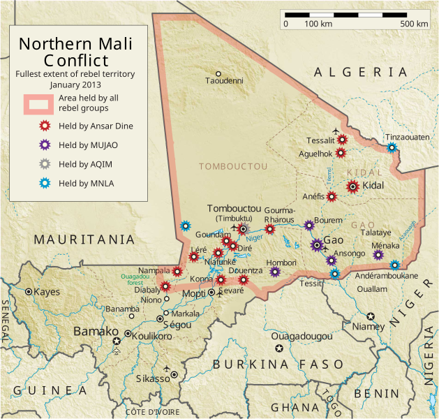
English: Map of the conflict in Northern Mali. (English)
العربية: خريطة الصّراع في شمال مالي. (إنجليزي)
Français : Carte du conflit au nord du Mali. (Anglais)
Latina: Charta rebellionis Tuaregorum in Malia septentrionali. (Anglice)
Українська: Карта конфлікту на півночі Малі. (Англійською) |
| Forrás |
A feltöltő saját munkája Ez a vektorgrafikus kép néhány olyan elemet tartalmaz, ami innen lett átvéve: Ez a vektorgrafikus kép néhány olyan elemet tartalmaz, ami innen lett átvéve: |
| Szerző | Orionist |
| Más változatok | German/Deutsch/Allemand, French/Français, Macedonian/македонски јазик/Macédonien |
| SVG kód | Ezen SVG kép forráskódja érvénytelen. Ez vektorgrafikus kép Adobe Illustrator segítségével készült, and with Inkscape. |
Notes
- ↑ US Department of State, "Country Reports on Terrorism 2011", Chapter 2 Country Reports: Africa Overview, 31 July 2012
Licenc
Én, e mű szerzője a művemet az alábbi licenc alatt teszem közzé:
Ez a fájl a Creative Commons Nevezd meg! – Így add tovább! 3.0 Unported licenc alapján használható fel.
- A következőket teheted a művel:
- megoszthatod – szabadon másolhatod, terjesztheted, bemutathatod és előadhatod a művet
- feldolgozhatod – származékos műveket hozhatsz létre
- Az alábbi feltételekkel:
- Nevezd meg! – A szerzőt megfelelően fel kell tüntetned, hivatkozást kell létrehoznod a licencre és jelezned kell, ha a művön változtatást hajtottál végre. Ezt bármilyen észszerű módon megteheted, kivéve oly módon, ami azt sugallná hogy a jogosult támogat téged vagy a felhasználásod körülményeit.
- Így add tovább! – Ha megváltoztatod, átalakítod, feldolgozod ezt a művet, a közreműködésedet csak az eredetivel megegyező vagy hasonló licenc alatt terjesztheted.
Fájltörténet
Kattints egy időpontra, hogy a fájl akkori állapotát láthasd.
| Dátum/idő | Bélyegkép | Felbontás | Feltöltő | Megjegyzés | |
|---|---|---|---|---|---|
| aktuális | 2014. április 8., 08:59 | | 1 316 × 1 255 (796 KB) | Ansh666 | Reverted to version as of 16:51, 8 March 2013 - restoring the correct version, as the map is supposed to be historical, not current |
| 2013. december 5., 22:15 |  | 1 316 × 1 255 (699 KB) | Hanibal911 | more accurately reflects the situation | |
| 2013. március 8., 18:51 |  | 1 316 × 1 255 (796 KB) | Agricolae | Hombori dot restored | |
| 2013. március 5., 16:29 |  | 1 316 × 1 255 (794 KB) | TUFKAAP | Since this is an English map, Al-Qaeda in the Islamic Maghreb should be abbreviated as AQIM. | |
| 2013. február 11., 05:33 |  | 1 316 × 1 255 (794 KB) | Agricolae | shift text distorted on upload | |
| 2013. február 11., 05:27 |  | 1 316 × 1 255 (794 KB) | Agricolae | change to show greatest extent - see WP Talk:Northern Mali conflict (2012–present) | |
| 2013. február 8., 08:36 |  | 1 316 × 1 255 (699 KB) | Rama | Aguelhok contested or taken ( http://www.lemonde.fr/afrique/article/2013/02/08/mali-les-forces-francaise-et-tchadiennes-a-aguelhok_1828906_3212.html ) | |
| 2013. február 2., 12:29 |  | 1 316 × 1 255 (698 KB) | U5K0 | Bourem to green as per talk page | |
| 2013. január 30., 10:41 |  | 1 316 × 1 255 (679 KB) | Orionist | Updated map: Menaka, Anderamboukane, Ansongo, Dire, Kidal and other MNLA positions. Removed rebel area boundaries as the situation has become complicated. | |
| 2013. január 29., 19:23 |  | 1 316 × 1 255 (894 KB) | Jaybear | Insertion of a map-scale in the upper right corner (added directly before the token "/svg" at end of svg-code); |
Fájlhasználat
Globális fájlhasználat
A következő wikik használják ezt a fájlt:
- Használata itt: af.wikipedia.org
- Használata itt: ar.wikipedia.org
- Használata itt: azb.wikipedia.org
- Használata itt: az.wikipedia.org
- Használata itt: bg.wikipedia.org
- Használata itt: bn.wikipedia.org
- Használata itt: ca.wikipedia.org
- Használata itt: cs.wikipedia.org
- Használata itt: cy.wikipedia.org
- Használata itt: da.wikipedia.org
- Használata itt: de.wikipedia.org
- Használata itt: el.wikipedia.org
- Használata itt: en.wikipedia.org
- Mali
- Portal:Mali
- Insurgency in the Maghreb (2002–present)
- War on terror
- User:Orionist/Gallery
- National Movement for the Liberation of Azawad
- Wikipedia talk:WikiProject Maps/Archive 2012
- Wikipedia:In the news/Candidates/April 2012
- Wikipedia:Graphics Lab/Map workshop/Archive/Apr 2012
- Wikipedia:Wikipedia Signpost/2012-04-30/WikiProject report
- Wikipedia:Wikipedia Signpost/Single/2012-04-30
- Mali War
- Wikipedia:WikiProject Maps/Conventions/Pushpin maps
- Operation Serval
- Chadian intervention in northern Mali
- Islamist insurgency in the Sahel
- User:AlbanianEditor1990/sandbox
- Használata itt: en.wikinews.org
- Használata itt: eo.wikipedia.org
- Használata itt: es.wikipedia.org
- Használata itt: et.wikipedia.org
- Használata itt: eu.wikipedia.org
- Használata itt: fi.wikipedia.org
A fájl globális használatának megtekintése