
Fájl:North East England counties 2009 map.svg

Ennek a(z) SVG fájlnak ezen PNG formátumú előnézete: 482 × 599 képpont. További felbontások: 193 × 240 képpont | 386 × 480 képpont | 618 × 768 képpont | 824 × 1 024 képpont | 1 647 × 2 048 képpont | 1 082 × 1 345 képpont.
Eredeti fájl (SVG fájl, névlegesen 1 082 × 1 345 képpont, fájlméret: 723 KB)
|
Ez a fájl a Wikimedia Commonsból származik. Az alább látható leírás az ottani dokumentációjának másolata. A Commons projekt szabad licencű kép- és multimédiatár. Segíts te is az építésében! |
Összefoglaló
| Leírás |
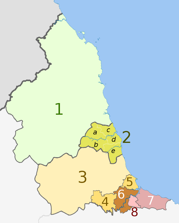
English: Map of the North East England region of England, showing its counties and administrative districts. The county colours are the same as those in File:English metropolitan and non-metropolitan counties 2009.svg.
Equirectangular map projection on WGS 84 datum, with N/S stretched 170% Geographic limits:
|
| Dátum | (UTC) |
| Forrás |
Ez a fájl ebből származik: |
| Szerző |
|
| Más változatok |
 |


| Map | Ceremonial county | Unitary authority | Metropolitan districts |
|---|---|---|---|
 |
1. Northumberland | ||
| 2. Tyne and Wear metropolitan county |
a) Newcastle upon Tyne, b) Gateshead, c) North Tyneside, d) South Tyneside, e) Sunderland | ||
| Durham | 3. Durham | ||
| 4. Darlington | |||
| 5. Hartlepool | |||
| 6. Stockton-on-Tees | |||
| North Yorkshire (part only) | |||
| 7. Redcar and Cleveland | |||
| 8. Middlesbrough | |||
Licenc
Ez a fájl a Creative Commons Nevezd meg! – Így add tovább! 3.0 Unported licenc alapján használható fel.
Így nevezd meg: Dr Greg and Nilfanion. Contains Ordnance Survey data © Crown copyright and database right 2011
- A következőket teheted a művel:
- megoszthatod – szabadon másolhatod, terjesztheted, bemutathatod és előadhatod a művet
- feldolgozhatod – származékos műveket hozhatsz létre
- Az alábbi feltételekkel:
- Nevezd meg! – A szerzőt megfelelően fel kell tüntetned, hivatkozást kell létrehoznod a licencre és jelezned kell, ha a művön változtatást hajtottál végre. Ezt bármilyen észszerű módon megteheted, kivéve oly módon, ami azt sugallná hogy a jogosult támogat téged vagy a felhasználásod körülményeit.
- Így add tovább! – Ha megváltoztatod, átalakítod, feldolgozod ezt a művet, a közreműködésedet csak az eredetivel megegyező vagy hasonló licenc alatt terjesztheted.
Eredeti feltöltési napló
This image is a derivative work of the following images:
- File:North_East_England__districts_2011_map.svg licensed with Cc-by-sa-3.0, GFDL
- 2011-05-01T18:56:43Z Nilfanion 1082x1345 (714062 Bytes) == Summary == {{Information |Description=Map of the [[w:North East England|North East England]] region showing the administrative districts. Equirectangular map projection on WGS 84 datum, with N/S stretched 170% Geographic
- File:English_ceremonial_counties_2010.svg licensed with Cc-by-sa-3.0, GFDL
- 2010-11-23T16:39:55Z Nilfanion 1108x1345 (308868 Bytes) thicker lines
- 2010-11-23T16:20:19Z Nilfanion 1108x1345 (301520 Bytes) tweaks
- 2010-10-26T20:34:20Z Nilfanion 817x990 (1391832 Bytes) {{Information |Description=Map showing the [[w:ceremonial counties of England]] including the City of London, in 2010. Equirectangular map projection on WGS 84 datum, with N/S stretched 170% Geographic limits: *West: 6.75W
Uploaded with derivativeFX
Fájltörténet
Kattints egy időpontra, hogy a fájl akkori állapotát láthasd.
| Dátum/idő | Bélyegkép | Felbontás | Feltöltő | Megjegyzés | |
|---|---|---|---|---|---|
| aktuális | 2018. augusztus 14., 22:16 | | 1 082 × 1 345 (723 KB) | Inops | change letters labelling the boroughs of Tyne and Wearfrom white to black. Hardly intelligible when thumbnailed otherwise |
| 2012. május 5., 22:11 |  | 1 082 × 1 345 (723 KB) | Dr Greg | lighten black boundary line | |
| 2012. május 2., 00:21 |  | 1 082 × 1 345 (723 KB) | Dr Greg | == {{int:filedesc}} == {{Information |Description={{en|Map of the North East England region of England, showing its counties and administrative districts. The county colours are the same as those in [[:File:English metropolitan... |
Fájlhasználat
Az alábbi lap használja ezt a fájlt:
Globális fájlhasználat
A következő wikik használják ezt a fájlt:
- Használata itt: ar.wikipedia.org
- Használata itt: ca.wikipedia.org
- Használata itt: de.wikipedia.org
- Használata itt: en.wikipedia.org
- Használata itt: es.wikipedia.org
- Használata itt: fa.wikipedia.org
- Használata itt: fr.wikipedia.org
- Használata itt: ja.wikipedia.org
- Használata itt: mr.wikipedia.org
- Használata itt: pl.wikipedia.org
- Használata itt: pnb.wikipedia.org
- Használata itt: th.wikipedia.org
- Használata itt: ur.wikipedia.org
- Használata itt: vi.wikipedia.org
- Használata itt: vls.wikipedia.org
- Használata itt: zh-yue.wikipedia.org