
Fájl:Kingdom of Hungary counties-2.svg

Ennek a(z) SVG fájlnak ezen PNG formátumú előnézete: 779 × 513 képpont. További felbontások: 320 × 211 képpont | 640 × 421 képpont | 1 024 × 674 képpont | 1 280 × 843 képpont | 2 560 × 1 686 képpont.
Eredeti fájl (SVG fájl, névlegesen 779 × 513 képpont, fájlméret: 265 KB)
|
Ez a fájl a Wikimedia Commonsból származik. Az alább látható leírás az ottani dokumentációjának másolata. A Commons projekt szabad licencű kép- és multimédiatár. Segíts te is az építésében! |
| Leírás |
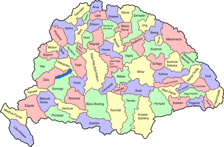
Map of counties of Kingdom of Hungary (Hungary proper and Croatia & Slavonia), 1886-1918. I have organised this into layers: Three layers of paths for the counties, for the county borders, and for external border. and one layer for the text labels. I have added basic styles and classified all elements. I have given all elements reasonable IDs the counties (the county name) and the borders (the names of the counties on each side) and the text labels (the names of the counties, with underscores indicating where they are split across labels). The counties are classed into four styles to make a four colour map, of course the colours can be changed just by changing the style (there as a fifth style for Lake Balaton, which does not show up very well on tis uploaded one). The main thing now is to fix the text styles. |
||
| Dátum | (UTC) | ||
| Forrás | |||
| Szerző |
|
||
| Más változatok |
|

| Ez egy retusált kép, ami azt jelenti, hogy az eredetihez képest digitálisan módosították. Módosítások: As described - added more useful metadata and structure. Az eredeti itt található: Kingdom of Hungary counties.svg. Módosította: SimonTrew.
|
Én, e mű szerzője a művemet az alábbi licenc alatt teszem közzé:
| Én, a szerző, ezt a művemet ezennel közkinccsé nyilvánítom. Ez a világ minden részén érvényes. Egyes országokban ez jogilag nem lehetséges. Ha így van, akkor: Jogot adok bárkinek, hogy bármilyen célból, feltétel nélkül használhassa ezt a fájlt, kivéve a törvény által kötelezően előírt feltételeket. |
Eredeti feltöltési napló
This image is a derivative work of the following images:
- File:Kingdom_of_Hungary_counties.svg licensed with PD-self
- 2007-08-20T20:25:30Z Xavax 779x513 (240591 Bytes) == Summary == {{Information| |Description= Map of counties of Hungary with Croatia & Slavonia, 1886-1918 |Source=own drawing |Date=April 30, 2006 |Author=[[User:IMeowbot]] |Permission= |other_versions= }} == Licensing == {{P
- 2006-04-30T22:10:47Z IMeowbot 779x513 (228524 Bytes) line weight
- 2006-04-30T21:34:49Z IMeowbot 779x513 (225942 Bytes)
- 2006-04-30T18:34:30Z IMeowbot 779x513 (199213 Bytes) {{Information| |Description= Map of late 1870s Hungary counties |Source=own drawing |Date=April 30, 2006 |Author=[[User:IMeowbot]] |Permission= |other_versions= }}
Uploaded with derivativeFX
Fájltörténet
Kattints egy időpontra, hogy a fájl akkori állapotát láthasd.
| Dátum/idő | Bélyegkép | Felbontás | Feltöltő | Megjegyzés | |
|---|---|---|---|---|---|
| aktuális | 2009. december 5., 19:57 | | 779 × 513 (265 KB) | SimonTrew | I missed some fixes of Veszprém |
| 2009. december 5., 19:55 |  | 779 × 513 (265 KB) | SimonTrew | Fix spelling of Vesprém, as I have just done on original. | |
| 2009. december 3., 16:29 |  | 779 × 513 (265 KB) | SimonTrew | Fix spelling of Pozsony, as I have just done on original work | |
| 2009. december 3., 15:37 |  | 779 × 513 (265 KB) | SimonTrew | Made four colour map. The text still only uses one style at the moment, this needs to be made to match the four styles used for the four colours for the counties, but this is easier to do once it is uploaded and I can print the png. Sorry if this is "not | |
| 2009. december 3., 13:29 |  | 779 × 513 (287 KB) | SimonTrew | Fixed the few errors in borders, removed unnecessary style fields from text (Inkscape adds them but they are covered by other fields), text still needs doing better | |
| 2009. december 3., 03:16 |  | 779 × 513 (286 KB) | SimonTrew | {{Information |Description=Map of counties of Kingdom of Hungary (Hungary proper and Croatia & Slavonia), 1886-1918. I have organised this into layers: Three layers of paths for the counties, for the county borders, and for external border. and one layer |
Fájlhasználat
Az alábbi lapok használják ezt a fájlt:
Globális fájlhasználat
A következő wikik használják ezt a fájlt:
- Használata itt: ar.wikipedia.org
- Használata itt: bs.wikipedia.org
- Használata itt: ceb.wikipedia.org
- Használata itt: ckb.wikipedia.org
- Használata itt: da.wikipedia.org
- Használata itt: de.wikipedia.org
- Használata itt: en.wikipedia.org
- User talk:Random user 8384993
- Wikipedia talk:WikiProject Hungary/Archive 2
- Module:Location map/data/Kingdom of Hungary/doc
- Wikipedia:Redirects for discussion/Log/2015 April 19
- User:Drkazmer/Jewish centres in the Kingdom of Hungary
- Wikipedia:Graphics Lab/Map workshop/Archive/2017/Sep 2017
- Module:Location map/data/Kingdom of Hungary
- Használata itt: fa.wikipedia.org
- Használata itt: fr.wikipedia.org
- Használata itt: kn.wikipedia.org
- Használata itt: pt.wikipedia.org
- Használata itt: rue.wikipedia.org
- Használata itt: si.wikipedia.org
- Használata itt: tg.wikipedia.org
- Használata itt: tr.wikipedia.org
- Használata itt: uz.wikipedia.org
- Használata itt: war.wikipedia.org