
Fájl:Israeli-Palestinian Railways.svg

Eredeti fájl (SVG fájl, névlegesen 1 660 × 2 748 képpont, fájlméret: 592 KB)
|
Ez a fájl a Wikimedia Commonsból származik. Az alább látható leírás az ottani dokumentációjának másolata. A Commons projekt szabad licencű kép- és multimédiatár. Segíts te is az építésében! |
Összefoglaló
| Leírás |
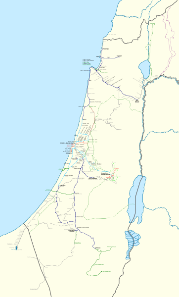
Français : Carte des chemins de fer Israéliens/Palestiniens.
English: This map shows all railways that have been operated by Palestine Railways, Israel Railways, or have existed on the territory of Israel/Palestine.
Certain sources show more train stations at:
I could not find a secondary source, and so they have been left out. There might also have been a Haifa-Wadi Rushmiya line. The station at Birein was probably more of a simple water refilling stop; this is possibly the same for other former stops in the Negev. The J'slm - El Bireh line was a military railway built by the British in 1918 to supply the war front North of Jerusalem. Very little information is available on it, and so its path is very hypothetical; this is also true for other lines (mostly in the Negev). Names: I tried to put former names where possible (space permitting). A plethora of translations, transliterations, and transcriptions exist when romanising Hebrew and Arabic station names. Since this map is in English, I have preferred the name that appeared the most "English" in my eyes. For clarity, a hyphen "-" is used to separate the town name from a qualifier. Borders: Undisputed borders 1949 Green line 1974 Purple line East Jerusalem municipal borders
Train Lines: Open (electrified) Open Open (freight only) Being built Closed |
| Dátum | |
| Forrás |
|
| Szerző | Mapeh |
| Más változatok |
A bigger version of this map exists: Israeli-Palestinian Railways (Full).svg. The source code for both is exactly the same: the only differences between the two are the boundaries (this map has smaller boundaries, therefore "cutting off" the empty parts: the Negev, the Sinai, and the Mediterranean), and which layers are visible (this map shows a schematic version of the Sinai Railway, while the full map shows a geographically accurate version). |
.svg)
Licenc
- A következőket teheted a művel:
- megoszthatod – szabadon másolhatod, terjesztheted, bemutathatod és előadhatod a művet
- feldolgozhatod – származékos műveket hozhatsz létre
- Az alábbi feltételekkel:
- Nevezd meg! – A szerzőt megfelelően fel kell tüntetned, hivatkozást kell létrehoznod a licencre és jelezned kell, ha a művön változtatást hajtottál végre. Ezt bármilyen észszerű módon megteheted, kivéve oly módon, ami azt sugallná hogy a jogosult támogat téged vagy a felhasználásod körülményeit.
- Így add tovább! – Ha megváltoztatod, átalakítod, feldolgozod ezt a művet, a közreműködésedet csak az eredetivel megegyező vagy hasonló licenc alatt terjesztheted.
Fájltörténet
Kattints egy időpontra, hogy a fájl akkori állapotát láthasd.
| Dátum/idő | Bélyegkép | Felbontás | Feltöltő | Megjegyzés | |
|---|---|---|---|---|---|
| aktuális | 2023. szeptember 16., 22:33 | | 1 660 × 2 748 (592 KB) | Crash48 | Eastern Railway being rebuilt: https://www.jpost.com/business-and-innovation/article-738891 |
| 2023. augusztus 23., 08:22 |  | 1 660 × 2 748 (592 KB) | Crash48 | +names of Bnei Brak – Ramat HaHayal (Tel Aviv – North) | |
| 2023. augusztus 22., 10:39 |  | 1 660 × 2 748 (591 KB) | Crash48 | Netanya-Lod-Ashkelon electrified | |
| 2023. augusztus 21., 21:48 |  | 1 660 × 2 748 (591 KB) | Crash48 | +Dor/Tantura, Zikhron Yaakov, Jaffa Docks | |
| 2023. augusztus 19., 00:26 |  | 1 660 × 2 748 (588 KB) | Crash48 | +Red LRT lines | |
| 2022. június 4., 12:20 |  | 1 660 × 2 748 (567 KB) | Glide08 | Updated to mark the Herzliya-Sharon-Ashkelon and Jerusalem-Modi'in electrified lines | |
| 2021. november 4., 01:05 |  | 1 660 × 2 748 (566 KB) | Glide08 | Updated to mark electrified lines as a separate color, and reflect on the extension of the Sharon Railway to Herzliya and the closure of the Beit Shemesh-Malha railway. | |
| 2020. május 2., 19:41 |  | 1 660 × 2 748 (574 KB) | Mapeh | Minor: fixed color of Mazkeret Batya station label | |
| 2020. március 17., 20:43 |  | 1 660 × 2 748 (551 KB) | Mapeh | Corrected the color of Mazkeret Batya station | |
| 2019. augusztus 18., 16:32 |  | 1 660 × 2 748 (574 KB) | My another account | 1) w:Mazkeret Batya railway station opened on 30/05/2019; 2) Change font for Nahariya to mark it as terminus; 3) Wilhelma was a separate station from Rantiya; 4) Tzrifin and Tel HaShomer stations were out of use by the time these settlements got their modern names. |
Fájlhasználat
Az alábbi lap használja ezt a fájlt:
Globális fájlhasználat
A következő wikik használják ezt a fájlt:
- Használata itt: ar.wikipedia.org
- Használata itt: de.wikipedia.org
- Használata itt: en.wikipedia.org
- Használata itt: he.wikipedia.org
- Használata itt: ru.wikipedia.org
- Használata itt: www.wikidata.org