
Fájl:East-Hem 800ad.jpg

Eredeti fájl (3 240 × 1 903 képpont, fájlméret: 3,51 MB, MIME-típus: image/jpeg)
|
Ez a fájl a Wikimedia Commonsból származik. Az alább látható leírás az ottani dokumentációjának másolata. A Commons projekt szabad licencű kép- és multimédiatár. Segíts te is az építésében! |

|
Ezt a képet el kellene készíteni vektorgrafika használatával SVG fájlként. A formátumnak számos előnye van; lásd a Commons:Media for cleanup lapot a további információkért. Ha a képnek már elérhető SVG-formátumú változata, töltsd fel. Az SVG feltöltése után cseréld le ezt a sablont a következőre: {{vector version available|új kép neve.svg}}.
|


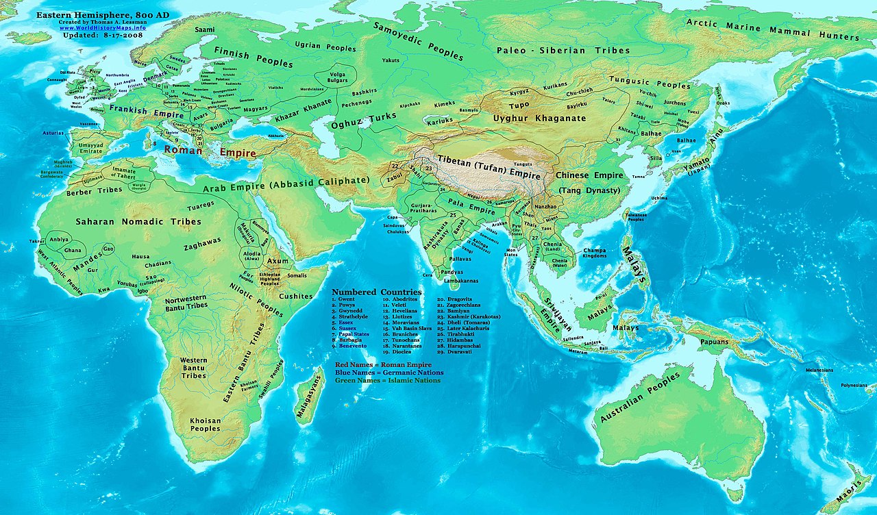
| Leírás | Eastern Hemisphere in 800 AD. |
| Forrás | self-made (For reference information, see the Map Source References section below.) |
| Szerző | Thomas Lessman (Contact!) |
| Engedély (Fájl újrafelhasználása) |
Én, e mű szerzője a művemet az alábbi licenc alatt teszem közzé: Ez a fájl a Creative Commons Nevezd meg! – Így add tovább! 3.0 Unported licenc alapján használható fel.
|
| Más változatok | see East-Hem_800ad.jpg file history on Wikipedia. |
Map Summary
Original Source URL: http://www.thomaslessman.com/History/images/East-Hem_800ad.jpg.
This map of the Eastern Hemisphere in 800 AD was created by Thomas Lessman, based on information from the sources listed below. This map is free for educational use (see Permission info above). When using this map, please mention that it is available for free at www.WorldHistoryMaps.info.
Map Source References
Remember, sources often conflict with each other. This map is only as accurate as the information that is available to me. To report any errors or to help further this work, please click here, or email Thomas Lessman at talessman@yis.us
References for information contained in this map:
1. Borders of Europe were mostly derived from the "Euratlas.com" map of Europe in 800 AD.
- (Please note: User:Bogomolov.PL has done a great job of showing me possible discrepancies in my north European borders compared to this source, due to the differences in the geographical layout of the maps.)
2. Asian information is mostly derived from the following sources:
- 2a. Wikimedia's The world in 750 CE and the World 820CE, created by User:Briangotts.
- 2b. Map of Asia in 750 AD, from Huhai.net.
- Please note: borders between Tibet and India are in question due to conflicts between source information:
- 2c. My depiction of Tibet's borders with India are based on these sources:
- 1: DK Atlas of World History (2000 edition, pg. 262), showing Tibet's borders in 800 AD, with northern India (the entire length of the Ganges, almost to the Indus river) under Tibet's control.
- 2: Huhai.net's map of Asia in 750 AD, which shows Tibetan control over Kamarupa, Bengal, and Pala.
- 3: "Himalayan Region, 500–1000 A.D." in Timeline of Art History. New York: The Metropolitan Museum of Art, (October 2001)
- 4: Google Book's "History of Tibet" (Page 54), makes several notes of Nepal's Licchavi dynasty as vassals of Tibet, and also says that India's Pala Empire under King Dharmapala accepted Tibetan overlordship.
- 5: Google Book's "Ancient India", (Page 632), describes Tibetan activities during the reigns of Songtsan Gampo and King Harsha of Kannauj. Also describes the Tibetan subjucation of Kamarupa and Kannauj after the death of King Harsha.
- 6: Wikipedia's article about Tibetan King Songtsän Gampo states that Tibet and Nepal invaded India in 648 AD and defeated Harsha's successor, after the Indian King had attacked a Chinese envoy named Wang Xuanze. (That statement referenced with Stein, R. A. Tibetan Civilization 1962. Revised English edition, 1972, Faber & Faber, London. Reprint, 1972. Stanford University Press, p. 62. ISBN 0-8047-0806-1 cloth; ISBN 0-8047-0901-7 pbk., pp. 58-59)
- Possible alternative borders for Indias Kamarupa, Gauda, Tripura, and Manipur can be seen on Porikolpok_Oxom's map of Kamarupa 7th-8th Century AD.
3. Much of the information in this map was cross-checked with Bruce Gordon's Regnal Chronologies.
Other Maps in this Series:
| Maps of the eastern hemisphere showing history
Bold dates are available on Wikimedia or Wikipedia. | ||
| Primeval | ||
| Ancient
|
·| 600 BC | 550 BC | 527 BC | 500 BC |
400 BC | ·| 1 AD | 50 AD | 100 AD | 200 AD | 300 AD | | |
| Medieval |
·| 500 AD | 565 AD | 600 AD | 700 AD | | |
| Modern |
·| 1500 AD | · * For historical maps of the whole world, | |
Other Info
Fájltörténet
Kattints egy időpontra, hogy a fájl akkori állapotát láthasd.
| Dátum/idő | Bélyegkép | Felbontás | Feltöltő | Megjegyzés | |
|---|---|---|---|---|---|
| aktuális | 2009. április 16., 11:20 | | 3 240 × 1 903 (3,51 MB) | Ukabia | Added Igbo. |
| 2008. augusztus 19., 00:46 |  | 3 240 × 1 903 (938 KB) | Talessman | Updated information on Asia & Africa. Corrected some information for India, Arab Empire, Europe, etc. | |
| 2008. május 9., 22:23 |  | 3 240 × 1 903 (749 KB) | Talessman | {{Information |Description=East Hemisphere in 800 AD |Source=self-made |Author= Talessman |Permission={{self|cc-by-sa-3.0}} }} |
Fájlhasználat
Az alábbi lapok használják ezt a fájlt:
Globális fájlhasználat
A következő wikik használják ezt a fájlt:
- Használata itt: an.wikipedia.org
- Használata itt: ar.wikipedia.org
- Használata itt: arz.wikipedia.org
- Használata itt: ast.wikipedia.org
- Használata itt: azb.wikipedia.org
- Használata itt: ba.wikipedia.org
- Használata itt: bg.wikipedia.org
- Használata itt: bs.wikipedia.org
- Használata itt: ca.wikipedia.org
- Használata itt: cs.wikipedia.org
- Használata itt: da.wikipedia.org
- Használata itt: de.wikipedia.org
- Használata itt: de.wikiversity.org
- Használata itt: el.wikipedia.org
- Használata itt: en.wikipedia.org
- 9th century
- History of the Khitans
- Proto-Mongols
- Tuvans
- Pyu city-states
- Turkic migration
- Portal:China/Anniversaries/November
- Portal:China/Anniversaries/November/November 20
- Nomadic empire
- Rashtrakuta literature
- User:Tompw/sandbox10
- Post-classical history
- File:Tibet 800ad.jpg
- User:Talessman/Maps
- User talk:Talessman/Maps
- Tibetan Empire
- History of Tuva
- History of the Uyghur people
- History of Champa
- User:Benjamin Trovato/sandbox
- Tang Standing Horse figure, Canberra
- User:Falcaorib
- Használata itt: es.wikipedia.org
- Használata itt: et.wikipedia.org
- Használata itt: fa.wikipedia.org
A fájl globális használatának megtekintése