
Fájl:BlankMap-World-Flattened.svg

Ennek a(z) SVG fájlnak ezen PNG formátumú előnézete: 800 × 406 képpont. További felbontások: 320 × 162 képpont | 640 × 325 képpont | 1 024 × 519 képpont | 1 280 × 649 képpont | 2 560 × 1 299 képpont | 2 754 × 1 397 képpont.
Eredeti fájl (SVG fájl, névlegesen 2 754 × 1 397 képpont, fájlméret: 1,68 MB)
|
Ez a fájl a Wikimedia Commonsból származik. Az alább látható leírás az ottani dokumentációjának másolata. A Commons projekt szabad licencű kép- és multimédiatár. Segíts te is az építésében! |
Összefoglaló
| Leírás |
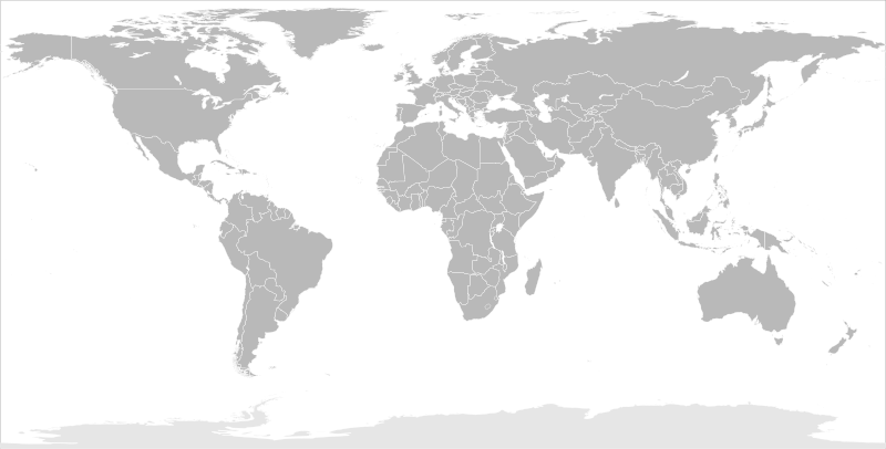
English: Blank political map of the world in modified (flattened) Robinson projection. This image is a sample of output from nugsl-worldmap, a Python script for the manipulation of this map. The script can also produce rotated images, add pinpoint marks at particular geographic coordinates, and produce web pages with clickable areas for specific countries and pinpoint marks.
Note that this map is not equirectangular, and cannot be used as a push-pin map to identify coordinates assuming equal latitude and longitude spacing. A map using the equirectangular projection is available at File:BlankMap-World6-Equirectangular.svg. |
| Dátum | (for the script only) |
| Forrás |
http://www.law.nagoya-u.ac.jp/en/appendix/software/worldmap/ Refactored from Image:BlankMap-World.svg, q.v. |
| Szerző | Frank Bennett |
| Engedély (Fájl újrafelhasználása) |
The map data manipulated by the script is in the public domain. The raw output of the script, including the file shown here, is also in the public domain. |
| Más változatok |
Származékos művek:
|
| SVG kód | Ez vektorgrafikus kép Inkscape segítségével készült. |
Licenc
| Én, a szerző, ezt a művemet ezennel közkinccsé nyilvánítom. Ez a világ minden részén érvényes. Egyes országokban ez jogilag nem lehetséges. Ha így van, akkor: Jogot adok bárkinek, hogy bármilyen célból, feltétel nélkül használhassa ezt a fájlt, kivéve a törvény által kötelezően előírt feltételeket. |
Fájltörténet
Kattints egy időpontra, hogy a fájl akkori állapotát láthasd.
| Dátum/idő | Bélyegkép | Felbontás | Feltöltő | Megjegyzés | |
|---|---|---|---|---|---|
| aktuális | 2014. március 20., 12:44 | | 2 754 × 1 397 (1,68 MB) | Underlying lk | fix classes for Soudan and South Soudan |
| 2013. március 16., 18:01 |  | 2 754 × 1 397 (1,68 MB) | Flappiefh | South Sudan added. | |
| 2008. január 14., 13:47 |  | 2 754 × 1 397 (1,67 MB) | Biercenator | Updated to current version of map produced by the script. | |
| 2007. december 19., 15:22 |  | 940 × 477 (1,99 MB) | Biercenator | == Summary == Refactored from en:Image:BlankMap-World6.svg, q.v. This image is a sample of output from [http://gsl-nagoya-u.net/appendix/software/worldmap/ nugsl-worldmap], a Python script for the manipulation and maintenance of this map. The flatt | |
| 2007. december 15., 17:31 |  | 940 × 477 (2 MB) | Biercenator | Refactored from en:Image:BlankMap-World6.svg, q.v. This image might prove useful if you want to change the area shown in the center of the Robinson projection version, since the conversion can be reversed. | |
| 2007. december 15., 17:18 |  | 940 × 477 (2 MB) | Biercenator | == Summary == Refactored from en:BlankMap-World6.svg, q.v. This image might prove useful if you want to area shown in the center of the Robinson projection version, since the conversion can be reversed. |
Fájlhasználat
Ezt a fájlt nem használja egyetlen lap sem.
Globális fájlhasználat
A következő wikik használják ezt a fájlt:
- Használata itt: ca.wikipedia.org
- Használata itt: de.wikipedia.org
- Használata itt: en.wikipedia.org
- Használata itt: es.wikipedia.org
- Használata itt: fr.wikipedia.org
- Használata itt: he.wikipedia.org