
Fájl:Austria satellite Grosslandschaften markerstyle.png
Eredeti fájl (2 457 × 1 318 képpont, fájlméret: 6,11 MB, MIME-típus: image/png)
|
Ez a fájl a Wikimedia Commonsból származik. Az alább látható leírás az ottani dokumentációjának másolata. A Commons projekt szabad licencű kép- és multimédiatár. Segíts te is az építésében! |
| Leírás |
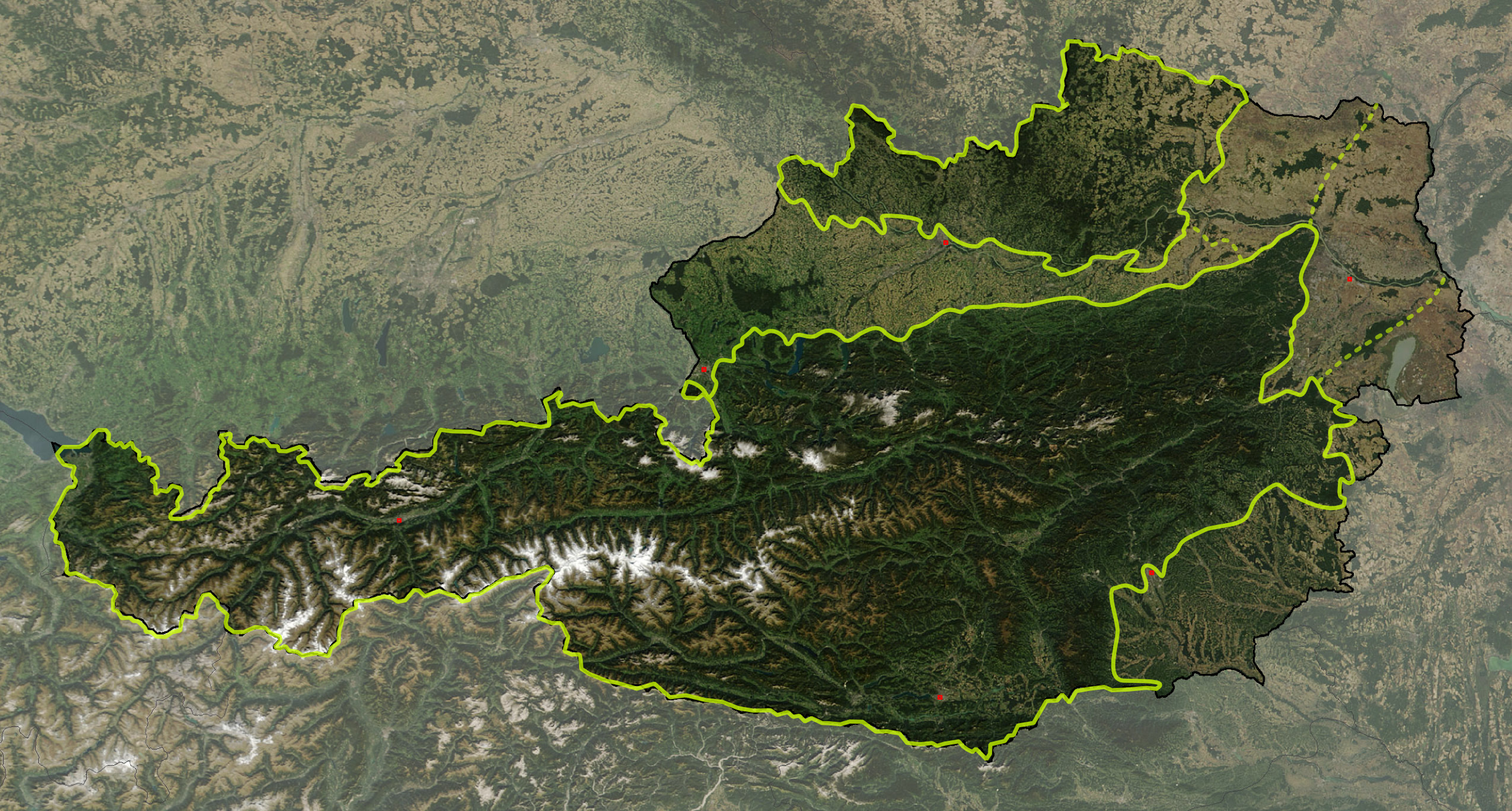
Deutsch: Satellitenbild von Österreich, mit den Großlandschaften: Österreichische Alpen, Vorländer und randalpine Becken, Granit- und Gneishochland
English: Satellite image of Austria with greater landscapes: Austrian Alps, Alpine Forelands and Rim Basins, Granite and Gneiss Highlands |
||
| Dátum | |||
| Forrás | The image is based on a satellite image from [1]. Original image: Credit Jeff Schmaltz, MODIS Rapid Response Team, NASA/GSFC. It was cropped and reduced in contrast around Austria by Michael Schmid, which is Image:Austria satellite unannotated.jpg. Borderlines added with Inkscape. | ||
| Szerző | W!B: | ||
| Engedély (Fájl újrafelhasználása) |
Based on a NASA image, thus in the public domain. | ||
| PNG kód |
|
![[1]](http://visibleearth.nasa.gov/images/5947/Italy.A2003262.1005.250m.jpg)
The borders of Austrian greater landscapes are derived from:
- Alps:
- W. Kilian, F. Müller, F. Starlinger: Die forstlichen Wuchsgebiete Österreichs. Eine Naturraumgliederung nach waldökologischen Gesichtspunkten. Forstliche Bundesversuchsanstalt, Wien 1993, ISSN 0374-9037 – online version
- They are slightly simplyfied and adjusted according to local customs, following the Alpenvereinsteilung der Ostalpen and on the NASA MODIS photo.
- The border of Granite and Gneiss Highlands is adjusted to the borders of Bohemian Mass to reflect the area, given in
- K. Ash: The 1:5 Million International Geological Map of Europe and Adjacent Areas., BGR, Hannover 2005
- Geologische Übersichtskarte der Republik Österreich. ed. Geologische Bundesanstalt, Vienna 1999
- Alpine Forelands: The borders between Alpine-Carpathian Forlands, Vienna Basin and Pannonian Basin follows visually the ridgelines of Alpine-Carpathian Cliffzone and Leithagebirge – Little Carpathians
The image is adjusted by some exactly referenced points (eg. capitals, NSEW extrempoints, ..) by geographical coordinate to rectangular othogonal projection, and stored 300 dpi, so it has a slightly different size (2457 x 1318 px) than Michael Schmid's image (2550 x 1381 px) – resizing was quite lossy with Inkscape, I'll fix that sometimes with Photoshop.
- Note, the darker shade of the Alps and the Granite and Gneiss Highlands ist not retouched, but from the original satellite picture: It reflects that these areas are mainly covered by forests (about 60% of Austria), while the Alpine Forelands are primarily agricultural regions – note the Kobernaußerwald/Hausruck forests of central Northern Forlands, Allentsteig region at northeast and Rosalia near Neusiedlersee at the far east)
| Ezt a fájlt a NASA készítette, ezért az Egyesült Államokban közkincsnek számít. A NASA szerzői jogi irányelve alapján „a NASA anyagai nem állnak szerzői jogi védelem alatt, kivéve, ha az külön jelezve van". (Lásd még: Sablon:PD-USGov, a NASA szerzői jogi- és a JPL képhasználati irányelve.) | ||
 |
Figyelmeztetések:
|
Fájltörténet
Kattints egy időpontra, hogy a fájl akkori állapotát láthasd.
| Dátum/idő | Bélyegkép | Felbontás | Feltöltő | Megjegyzés | |
|---|---|---|---|---|---|
| aktuális | 2008. március 18., 13:57 | | 2 457 × 1 318 (6,11 MB) | W!B: | {{Information |Description= |Source=The image is based on a satellite image from [http://visibleearth.nasa.gov/images/5947/Italy.A2003262.1005.250m.jpg]. Original image: Credit Jeff Schmaltz, MODIS Rapid Response Team, NASA/GSFC. It was cropped and reduc |
Fájlhasználat
Az alábbi lap használja ezt a fájlt:
Globális fájlhasználat
A következő wikik használják ezt a fájlt:
- Használata itt: cs.wikipedia.org
- Használata itt: de.wikipedia.org
- Használata itt: fr.wikipedia.org
- Használata itt: is.wikipedia.org
- Használata itt: ka.wikipedia.org
- Használata itt: sv.wikipedia.org
- Használata itt: www.wikidata.org