
Fájl:Ankara districts.png
Nem érhető el nagyobb felbontású változat.
Ankara_districts.png (733 × 600 képpont, fájlméret: 166 KB, MIME-típus: image/png)
|
Ez a fájl a Wikimedia Commonsból származik. Az alább látható leírás az ottani dokumentációjának másolata. A Commons projekt szabad licencű kép- és multimédiatár. Segíts te is az építésében! |
Összefoglaló
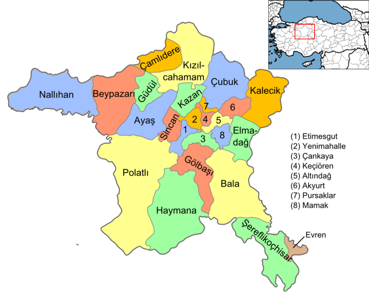
| Leírás |
English: Map of the districts of Ankara province of Turkey. Created by Rarelibra 16:37, 1 December 2006 (UTC) for public domain use, using MapInfo Professional v8.5 and various mapping resources. Edited by One Homo Sapiens Corrected text where İ,Ş,ı,ğ,or ş occurs in name. Source: [statoids-com]. Increased font size and enhanced color differences among adjacent districts. |
| Dátum | 2006. december 1. (eredeti feltöltésének dátuma) |
| Forrás | Nincs megadva géppel olvasható forrás. Feltételezhetően saját munka (a szerzői jogi adatok alapján). |
| Szerző | Nincs megadva géppel olvasható szerző. Feltételezhetően Rarelibra (a szerzői jogi adatok alapján). |
Licenc
| Én, a szerző, ezt a művemet ezennel közkinccsé nyilvánítom. Ez a világ minden részén érvényes. Egyes országokban ez jogilag nem lehetséges. Ha így van, akkor: Jogot adok bárkinek, hogy bármilyen célból, feltétel nélkül használhassa ezt a fájlt, kivéve a törvény által kötelezően előírt feltételeket. |
Fájltörténet
Kattints egy időpontra, hogy a fájl akkori állapotát láthasd.
| Dátum/idő | Bélyegkép | Felbontás | Feltöltő | Megjegyzés | |
|---|---|---|---|---|---|
| aktuális | 2015. szeptember 15., 17:08 | | 733 × 600 (166 KB) | AylakBiri | Yeni sınırlar. |
| 2014. június 1., 20:59 |  | 1 056 × 864 (198 KB) | Joseph48 | - "Pursaklar" added. - Borders changed using File:Ankara location Pursaklar.svg | |
| 2011. október 22., 20:00 |  | 1 056 × 816 (48 KB) | Karedefter | small things | |
| 2010. november 21., 21:40 |  | 1 056 × 816 (48 KB) | Joseph48 | Şultan Koçhisar > Şerefli Koçhisar | |
| 2008. december 28., 22:37 |  | 1 056 × 816 (41 KB) | One Homo Sapiens | Corrected text where İ,Ş,ı,ğ,or ş occurs in name. Source: [statoids-com]. Increased font size and enhanced color differences among adjacent districts. | |
| 2006. december 1., 18:37 |  | 1 056 × 816 (40 KB) | Rarelibra | Map of the districts of Ankara province of Turkey. Created by ~~~~ for public domain use, using MapInfo Professional v8.5 and various mapping resources. |
Fájlhasználat
Az alábbi lapok használják ezt a fájlt:
Globális fájlhasználat
A következő wikik használják ezt a fájlt:
- Használata itt: ar.wikipedia.org
- Használata itt: azb.wikipedia.org
- Használata itt: az.wikipedia.org
- Használata itt: ba.wikipedia.org
- Használata itt: be.wikipedia.org
- Használata itt: br.wikipedia.org
- Használata itt: ca.wikipedia.org
- Használata itt: ceb.wikipedia.org
- Használata itt: ckb.wikipedia.org
- Használata itt: crh.wikipedia.org
- Használata itt: cs.wikipedia.org
- Használata itt: cy.wikipedia.org
- Használata itt: de.wikipedia.org
A fájl globális használatának megtekintése