
Fájl:1730 Stoopendaal Map of the World in two Hemispheres - Geographicus - WereltCaert-stoopendaal-1730.jpg
Az előnézet mérete: 800 × 553 képpont További felbontások: 320 × 221 képpont | 640 × 442 képpont | 1 024 × 708 képpont | 1 280 × 885 képpont | 2 560 × 1 770 képpont | 4 000 × 2 765 képpont.
Eredeti fájl (4 000 × 2 765 képpont, fájlméret: 3,73 MB, MIME-típus: image/jpeg)
|
Ez a fájl a Wikimedia Commonsból származik. Az alább látható leírás az ottani dokumentációjának másolata. A Commons projekt szabad licencű kép- és multimédiatár. Segíts te is az építésében! |
| Werelt Caert. | ||||||
|---|---|---|---|---|---|---|
| Művész | ||||||
| Mű címe |
Werelt Caert. |
|||||
| Leírás |
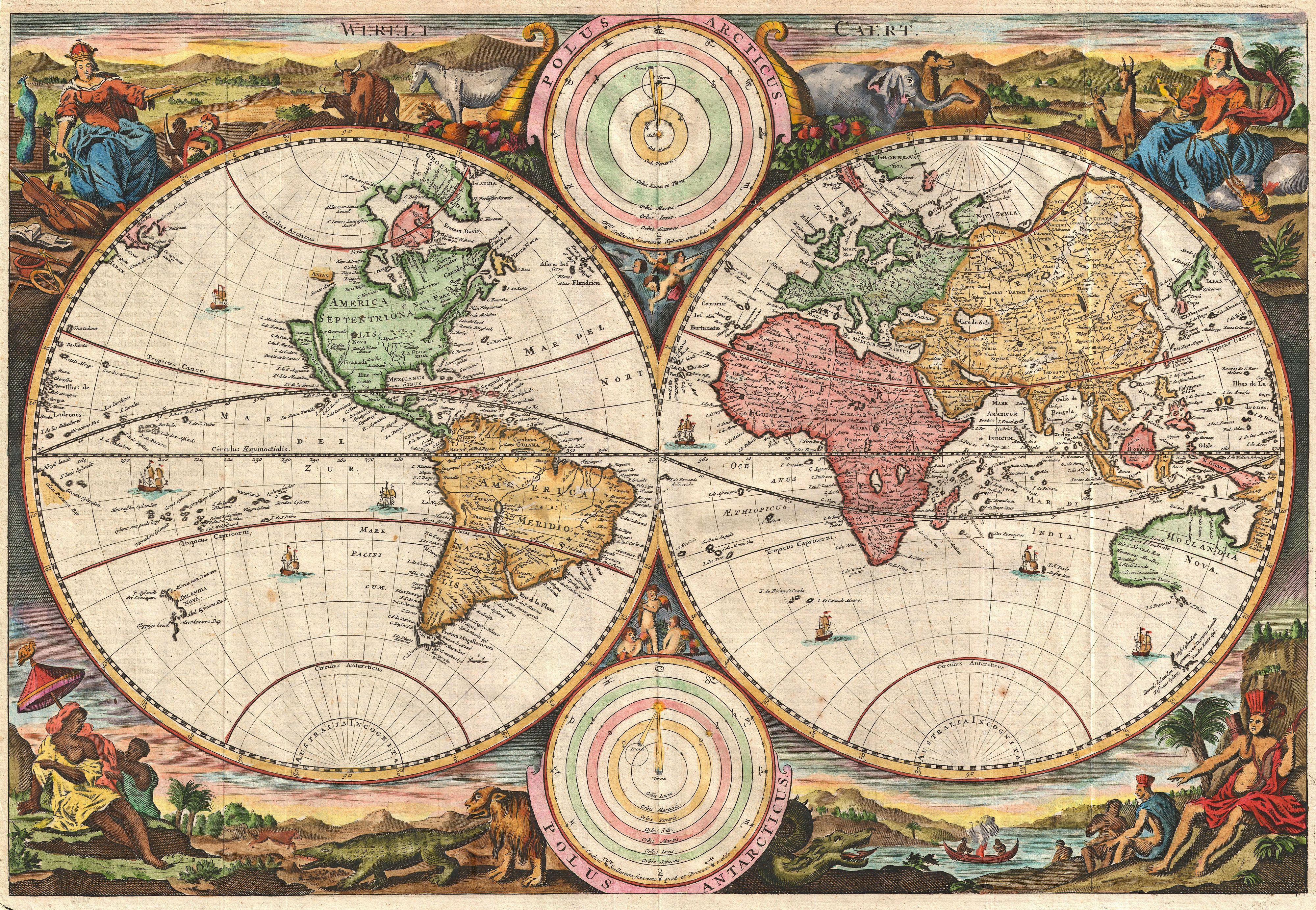
English: A fine 1730 world map was drawn by Stoopendaal for publication in the Keur Bible. Based on Visscher’s very similar map of 1663, this map depicts the world on a hemisphere projection surrounded by stunning allegorical cartouche work. The cartouche work corresponds to that seen on the second world Bible map produced by Nicolaas Visscher, Orbis Terrarum Tabula Recens Emendata ... (Shirley 431, 1663), though the map has changed to accommodate evolving geographical suppositions. Stoopendaal revisions of Visscher’s work include geographical updates as well as the incorporation of Copernican and Ptolemaic solar systems in the place of Visscher’s polar projections – though curiously Visscher’s labels remain. Cartographically Stoopendaal probably references Pieter Goos world map of 1666, Orbis Terrarum Nova Et Accuratissima Tabula ... (Shirley 438), to which this map is similar. . Our survey of this map will begin in North America where Stoopendaal has updated Visscher’s model to incorporate the convention of a flat topped insular California. The concept of an insular California first appeared as a work of fiction in Garci Rodriguez de Montalvo's c. 1510 romance Las Sergas de Esplandian, where he writes Know, that on the right hand of the Indies there is an island called California very close to the side of the Terrestrial Paradise; and it is peopled by black women, without any man among them, for they live in the manner of Amazons. Baja California was subsequently discovered in 1533 by Fortun Ximenez, who had been sent to the area by Hernan Cortez. When Cortez himself traveled to Baja, he must have had Montalvo's novel in mind, for he immediately claimed the Island of California for the Spanish King. By the late 16th and early 17th century ample evidence had been amassed, through explorations of the region by Francisco de Ulloa, Hernando de Alarcon, and others, that California was in fact a peninsula. However, by this time other factors were in play. Francis Drake had sailed north and claimed New Albion near modern day Washington or Vancouver for England. The Spanish thus needed to promote Cortez's claim on the Island of California to preempt English claims on the western coast of North America. The significant influence of the Spanish crown on European cartographers caused a major resurgence of the Insular California theory. Around the same time this map was drawn Eusebio Kino, a Jesuit missionary, published his own 1705 account of travels overland from Mexico to California, establishing conclusively the peninsularity of California. Stoopendaal’s rendering of the Great Lakes as a single body of water open to the west is of particular interest and is the most ephemeral element of this map, being updated in subsequent editions to reflect ongoing European exploration of the region. The unusual rendering of the Great Lakes shown here is unique to Visscher’s work and appears in several of his maps. At first glance Visscher’s great inland sea appears uncannily like Verazanno’s Sea, a 16th century speculative body of water extending to the Pacific through the center of North America, which was no doubt a direct influence on the water form established here. In some early maps, Visscher describes his inland sea with the following Latin note: Lacus iste quantum ex accolis colligi potuiy trecenta ut minimum miliaria en longitudinem pateat This lake, as far as can be learned from the inhabitants, stretches at least three hundred miles in length This is curiously identical to the text used by Jodocus Hondius on his world map of 1611 to describe his rendering of Verazanno’s Sea. Later maps would see this great inland sea replaced by more contemporary rendering of the Great Lakes taken from the explorations of La Salle, Hennepin, and others. |
|||||
| Dátum | 1730 (undated) | |||||
| Méretei | magasság: 12,5 hüvelyk (31,7 cm); szélesség: 18,5 hüvelyk (46,9 cm) | |||||
| Leltári szám |
Geographicus link: WereltCaert-stoopendaal-1730 |
|||||
| Forrás/fényképész |
Biblia,dat is De gantsche H. Schrufture, Pieter and Jacob Keur, 1730.
|
|||||
| Engedély (Fájl újrafelhasználása) |
|
|||||
| Más változatok |
 |
|||||
.jpg)
Fájltörténet
Kattints egy időpontra, hogy a fájl akkori állapotát láthasd.
| Dátum/idő | Bélyegkép | Felbontás | Feltöltő | Megjegyzés | |
|---|---|---|---|---|---|
| aktuális | 2011. március 25., 10:06 | | 4 000 × 2 765 (3,73 MB) | BotMultichillT | {{subst:User:Multichill/Geographicus |link=http://www.geographicus.com/P/AntiqueMap/WereltCaert-stoopendaal-1730 |product_name=1730 Stoopendaal Map of the World in two Hemispheres |map_title=Werelt Caert. |description=A fine 1730 world map was drawn by Da |
Fájlhasználat
Az alábbi lap használja ezt a fájlt:
Globális fájlhasználat
A következő wikik használják ezt a fájlt:
- Használata itt: de.wikipedia.org
- Használata itt: fi.wikipedia.org
- Használata itt: it.wikipedia.org
- Használata itt: la.wikipedia.org
- Használata itt: no.wikipedia.org