
Fájl:Water Detected at High Latitudes on the Moon.jpg
Az előnézet mérete: 600 × 600 képpont További felbontások: 240 × 240 képpont | 480 × 480 képpont | 768 × 768 képpont | 1 024 × 1 024 képpont | 1 950 × 1 950 képpont.
Eredeti fájl (1 950 × 1 950 képpont, fájlméret: 536 KB, MIME-típus: image/jpeg)
|
Ez a fájl a Wikimedia Commonsból származik. Az alább látható leírás az ottani dokumentációjának másolata. A Commons projekt szabad licencű kép- és multimédiatár. Segíts te is az építésében! |
Összefoglaló
| Leírás |
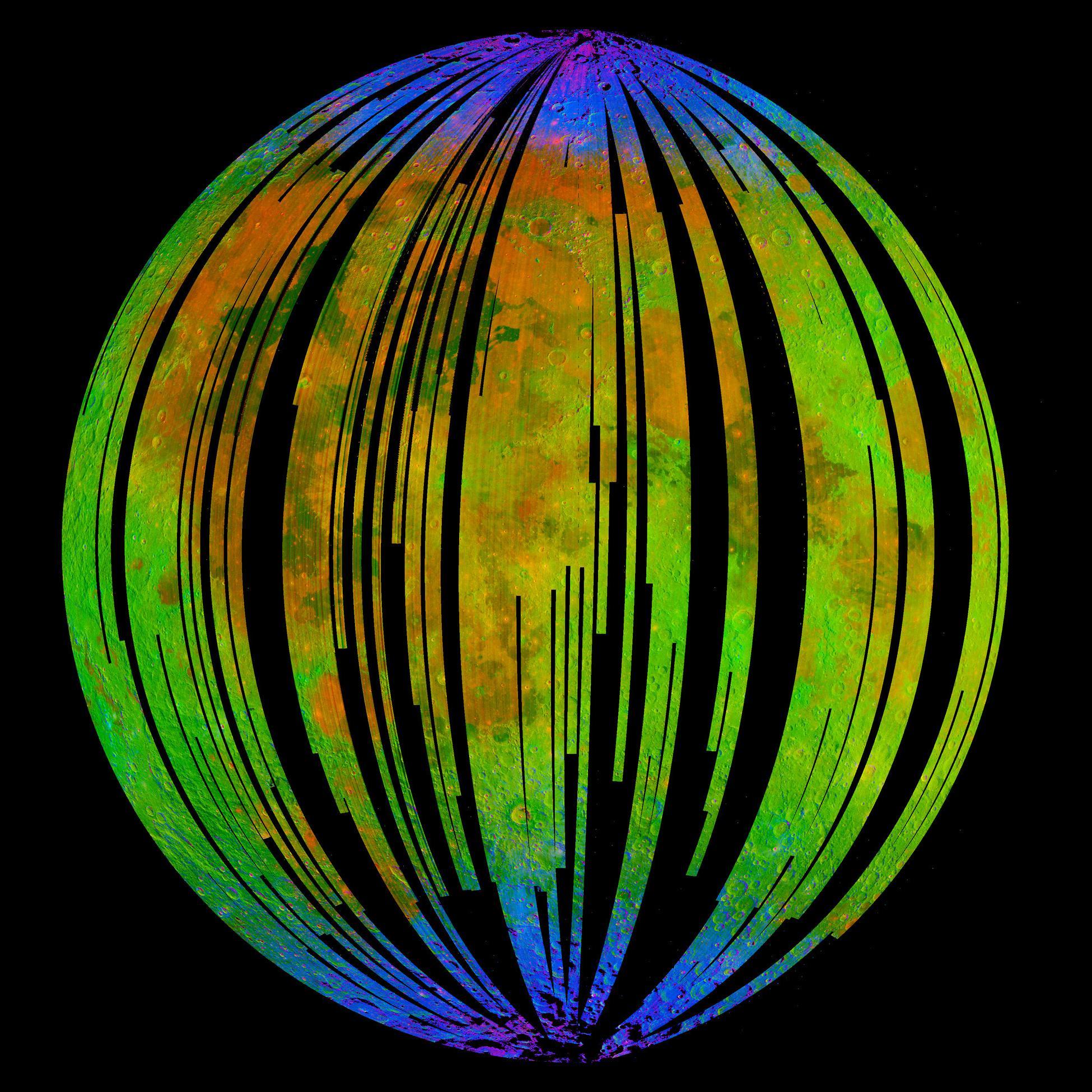
English: NASA's Moon Mineralogy Mapper, an instrument on the Indian Space Research Organization's Chandrayaan-1 mission, took this image of Earth's moon. It is a three-colour composite of reflected near-infra-red radiation from the sun, and illustrates the extent to which different materials are mapped across the side of the moon that faces Earth. Small amounts of water were detected on the surface of the moon at various locations. This image illustrates their distribution at high latitudes toward the poles. Blue shows the signature of water, green shows the brightness of the surface as measured by reflected infra-red radiation from the sun and red shows a mineral called pyroxene. |
| Dátum | |
| Forrás | NASA Image of the Day |
| Szerző | ISRO/NASA/JPL-Caltech/Brown Univ./USGS |
Licenc
| Ezt a fájlt a NASA készítette, ezért az Egyesült Államokban közkincsnek számít. A NASA szerzői jogi irányelve alapján „a NASA anyagai nem állnak szerzői jogi védelem alatt, kivéve, ha az külön jelezve van". (Lásd még: Sablon:PD-USGov, a NASA szerzői jogi- és a JPL képhasználati irányelve.) | ||
 |
Figyelmeztetések:
|
Fájltörténet
Kattints egy időpontra, hogy a fájl akkori állapotát láthasd.
| Dátum/idő | Bélyegkép | Felbontás | Feltöltő | Megjegyzés | |
|---|---|---|---|---|---|
| aktuális | 2009. szeptember 25., 21:52 | | 1 950 × 1 950 (536 KB) | Originalwana | {{Information |Description={{en|1=NASA's Moon Mineralogy Mapper, an instrument on the Indian Space Research Organization's Chandrayaan-1 mission, took this image of [[Earth] |
Fájlhasználat
Az alábbi lapok használják ezt a fájlt:
Globális fájlhasználat
A következő wikik használják ezt a fájlt:
- Használata itt: beta.wikiversity.org
- Használata itt: en.wikipedia.org
- Használata itt: en.wikiversity.org
- Használata itt: es.wikipedia.org
- Használata itt: fr.wikipedia.org
- Használata itt: gl.wikipedia.org
- Használata itt: id.wikipedia.org
- Használata itt: it.wikipedia.org
- Használata itt: ja.wikipedia.org
- Használata itt: mr.wikipedia.org
- Használata itt: pnb.wikipedia.org
- Használata itt: ro.wikipedia.org
- Használata itt: ru.wikipedia.org
- Használata itt: tr.wikipedia.org
- Használata itt: uk.wikipedia.org
- Használata itt: ur.wikipedia.org
- Használata itt: zh.wikipedia.org