
Fájl:Tutankhamen map Valle Re Nilo space STS026-041-058.jpg
Eredeti fájl (5 104 × 5 104 képpont, fájlméret: 18,06 MB, MIME-típus: image/jpeg)
|
Ez a fájl a Wikimedia Commonsból származik. Az alább látható leírás az ottani dokumentációjának másolata. A Commons projekt szabad licencű kép- és multimédiatár. Segíts te is az építésében! |
Összefoglaló
| Leírás |
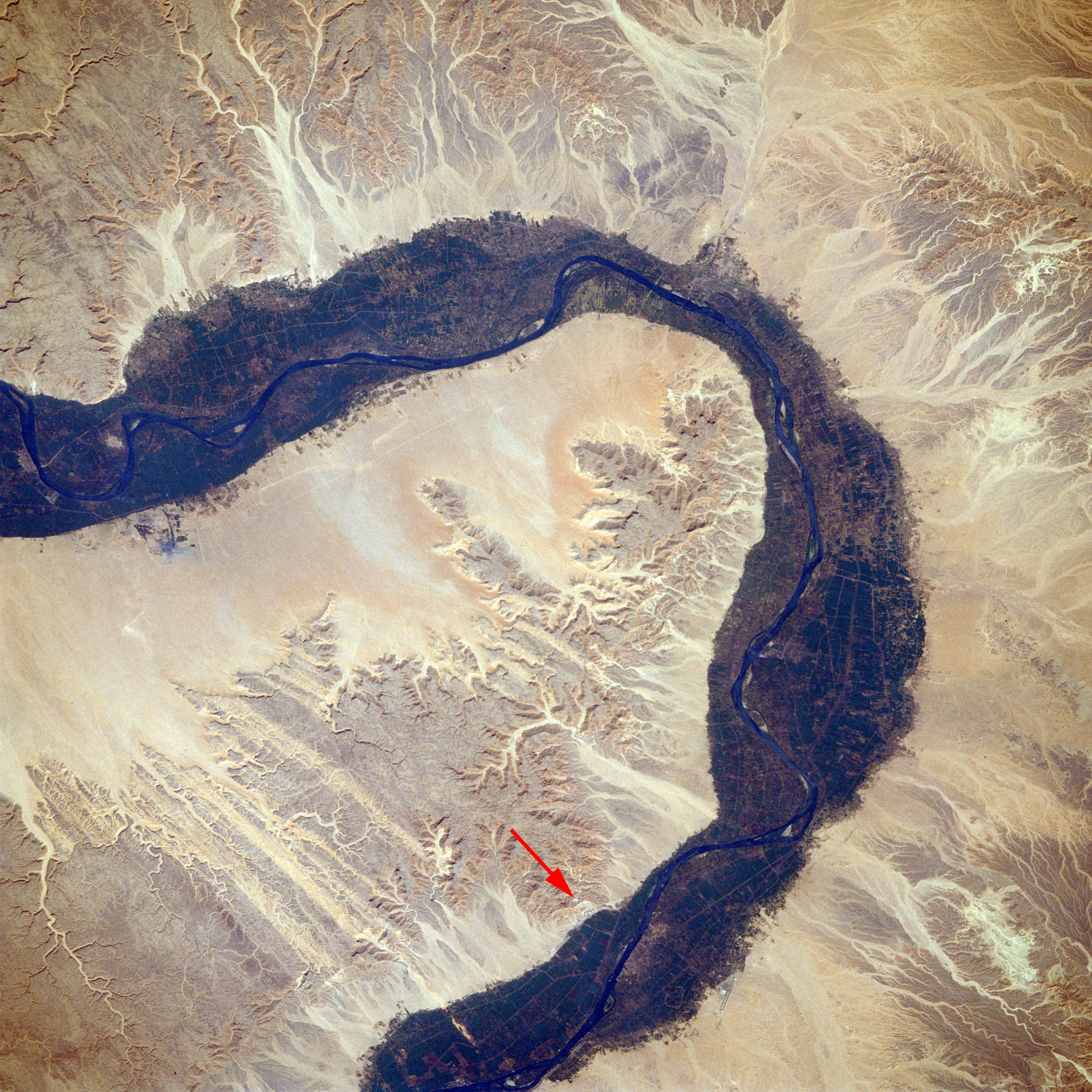
English: Valley of the Kings, Southern Egypt October 1988
Arid landforms comprise much of this nearly vertical view of a portion of the Nile River. These desert landforms include eroded valleys and wadis (watercourses). The fertile and highly productive green Nile River Valley stands out in marked contrast to the tan desert landscape on either side. This part of the Nile Valley varies in width from 4 to 9 miles (6 to 14 kilometers). Near the southern edge of this photograph, the city of Luxor can be ascertained along the eastern bank of the Nile. The narrow, linear runways of the airport are visible on the edge of the desert east of the city. This particular bend in the Nile River is the home of many historical points of interest-Valley of the Kings, Valley of the Queens, Temple of Luxor, Tomb of Tutankhamen, and Necropolis of Thebes. Italiano: Valle dei Re, Egitto Meridionale, Ottobre 1988
La maggior parte di questa fotografia, ripresa circa sulla verticale di una parte del fiume Nilo, comprende territori desertici. Questo territorio desertico include valli erose e torrenti stagionali. La verde Valle sulla riva del Nilo, fertile e molto produttiva si estende in un marcato contrasto con il panorama desertico da entrambe le rive. Questa parte della Valle del Nilo ha una larghezza che varia da 6 a 14 chilometri (4 a 6 miglia). Si può riconoscere la città di Luxor, vicino al bordo meridionale di questa fotografia, lungo la riva orientale del Nilo. A Est della città, sul bordo del deserto, sono visibili le strette e diritte piste di atterraggio dell'aeroporto. Questa particolare fascia della riva del Nilo è sede di molti punti di interesse storico come la Valle dei Re, la Valle della Regine, il Tempio di Luxor, la tomba di Tutankhamen e l'antico cimitero di Tebe. STS026-041-058 è una sigla che indica in modo univoco la fonte di questa foto, STS026 è la sigla della missione shuttle Discovery che ha ripreso la foto n° 041-058. |
| Dátum | |
| Forrás | EARTH FROM SPACE Valley of the King STS026-041-058 |
| Szerző | NASA/Crew of STS-26 |
| Más változatok | Valley of the Kings from space STS026-041-058.tif – NASA's original |
Ezt a képet vagy videót az Amerikai Egyesült Államok Nemzeti Légügyi és Űrhajózási Hivatalának (NASA) Johnson Űrközpontjakategorizálta a következő azonosító kód alatt: fénykép-azonosító: STS026-041-058. Ez a sablon nem a licenc jelölésére szolgál. Szükség van egy licencsablonra is. Lásd a Commons:Licencelés lapot. Más nyelvek:
|
Licenc
This file is in the public domain in the United States because it was created by the Image Science & Analysis Laboratory, of the NASA Johnson Space Center. NASA copyright policy states that "NASA material is not protected by copyright unless noted". (NASA media use guidelines or Conditions of Use of Astronaut Photographs).
Photo source: STS026-041-058.
|
Fájltörténet
Kattints egy időpontra, hogy a fájl akkori állapotát láthasd.
| Dátum/idő | Bélyegkép | Felbontás | Feltöltő | Megjegyzés | |
|---|---|---|---|---|---|
| aktuális | 2014. november 12., 01:53 | | 5 104 × 5 104 (18,06 MB) | Ras67 | high resolution |
| 2007. március 4., 17:40 |  | 640 × 640 (193 KB) | Noclador | Valley of the Kings, location corrected. | |
| 2005. augusztus 19., 11:37 |  | 640 × 640 (77 KB) | Roger469 | {{PD-NASA}} |
Fájlhasználat
Az alábbi lapok használják ezt a fájlt:
Globális fájlhasználat
A következő wikik használják ezt a fájlt:
- Használata itt: af.wikipedia.org
- Használata itt: ar.wikipedia.org
- Használata itt: bg.wikipedia.org
- Használata itt: bn.wikipedia.org
- Használata itt: el.wikipedia.org
- Használata itt: en.wikipedia.org
- Használata itt: ha.wikipedia.org
- Használata itt: hr.wikipedia.org
- Használata itt: hy.wikipedia.org
- Használata itt: it.wikipedia.org
- Használata itt: la.wikipedia.org
- Használata itt: lv.wikipedia.org
- Használata itt: mk.wikipedia.org
- Használata itt: ml.wikipedia.org
- Használata itt: ms.wikipedia.org
- Használata itt: nn.wikipedia.org
- Használata itt: no.wikipedia.org
- Használata itt: pt.wikipedia.org
- Használata itt: ro.wikipedia.org
- Használata itt: ru.wikipedia.org
- Használata itt: sh.wikipedia.org
- Használata itt: simple.wikipedia.org
- Használata itt: so.wikipedia.org
- Használata itt: sw.wikipedia.org
- Használata itt: ta.wikipedia.org
- Használata itt: th.wikipedia.org
- Használata itt: tl.wikipedia.org
- Használata itt: tr.wikipedia.org
- Használata itt: uk.wikipedia.org
- Használata itt: uz.wikipedia.org
- Használata itt: vi.wikipedia.org