
Fájl:The Danube Spills into the Black Sea.jpg

Az előnézet mérete: 669 × 600 képpont További felbontások: 268 × 240 képpont | 535 × 480 képpont | 857 × 768 képpont | 1 142 × 1 024 képpont | 2 080 × 1 865 képpont.
Eredeti fájl (2 080 × 1 865 képpont, fájlméret: 1,07 MB, MIME-típus: image/jpeg)
|
Ez a fájl a Wikimedia Commonsból származik. Az alább látható leírás az ottani dokumentációjának másolata. A Commons projekt szabad licencű kép- és multimédiatár. Segíts te is az építésében! |
Összefoglaló
| Leírás |
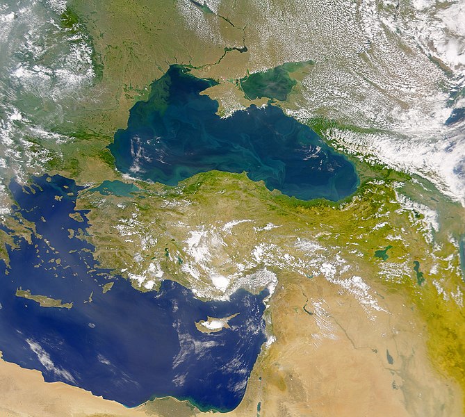
English: This cloud-free Sea-viewing Wide Field-of-view Sensor (SeaWiFS) view of the Black Sea reveals the colourful interplay of currents on the lake’s surface. The green crescent shaped pattern in the north-western corner of the Black Sea is due to the nutrient-rich, sediment-laden discharge of the Danube River stimulating biological activity. The brighter, more turquoise patterns on the lake to the south and east are probably blooms of another type of phytoplankton. |
| Dátum | |
| Forrás | NASA Earth Observatory |
| Szerző | The SeaWiFS Project |
Image courtesy of the NASA/Goddard Space Flight Center, and ORBIMAGE.
Licenc
| Ezt a fájlt a NASA készítette, ezért az Egyesült Államokban közkincsnek számít. A NASA szerzői jogi irányelve alapján „a NASA anyagai nem állnak szerzői jogi védelem alatt, kivéve, ha az külön jelezve van". (Lásd még: Sablon:PD-USGov, a NASA szerzői jogi- és a JPL képhasználati irányelve.) | ||
 |
Figyelmeztetések:
|
Fájltörténet
Kattints egy időpontra, hogy a fájl akkori állapotát láthasd.
| Dátum/idő | Bélyegkép | Felbontás | Feltöltő | Megjegyzés | |
|---|---|---|---|---|---|
| aktuális | 2010. április 20., 13:20 | | 2 080 × 1 865 (1,07 MB) | Originalwana | {{Information |Description={{en|1=This cloud-free Sea-viewing Wide Field-of-view Sensor (SeaWiFS) view of the Black Sea reveals the colourful interplay of currents on the lake’s surface. The green crescent shaped pattern in the north-western cor |
Fájlhasználat
Az alábbi lap használja ezt a fájlt:
Globális fájlhasználat
A következő wikik használják ezt a fájlt:
- Használata itt: ady.wikipedia.org
- Használata itt: crh.wikipedia.org
- Használata itt: en.wikipedia.org
- Használata itt: eo.wikipedia.org
- Használata itt: fr.wikipedia.org
- Használata itt: gu.wikipedia.org
- Használata itt: hak.wikipedia.org
- Használata itt: hr.wikipedia.org
- Használata itt: ilo.wikipedia.org
- Használata itt: ja.wikipedia.org
- Használata itt: kn.wikipedia.org
- Használata itt: lg.wikipedia.org
- Használata itt: pl.wikipedia.org
- Használata itt: rm.wikipedia.org
- Használata itt: sr.wikipedia.org
- Használata itt: ta.wikipedia.org
- Használata itt: uk.wikipedia.org
- Használata itt: vi.wikipedia.org
- Használata itt: wuu.wikipedia.org
- Használata itt: zh.wikipedia.org