
Fájl:PIA00245 Baltis Vallis.jpg

Eredeti fájl (2 150 × 2 150 képpont, fájlméret: 1,99 MB, MIME-típus: image/jpeg)
|
Ez a fájl a Wikimedia Commonsból származik. Az alább látható leírás az ottani dokumentációjának másolata. A Commons projekt szabad licencű kép- és multimédiatár. Segíts te is az építésében! |
Összefoglaló
| Leírás |
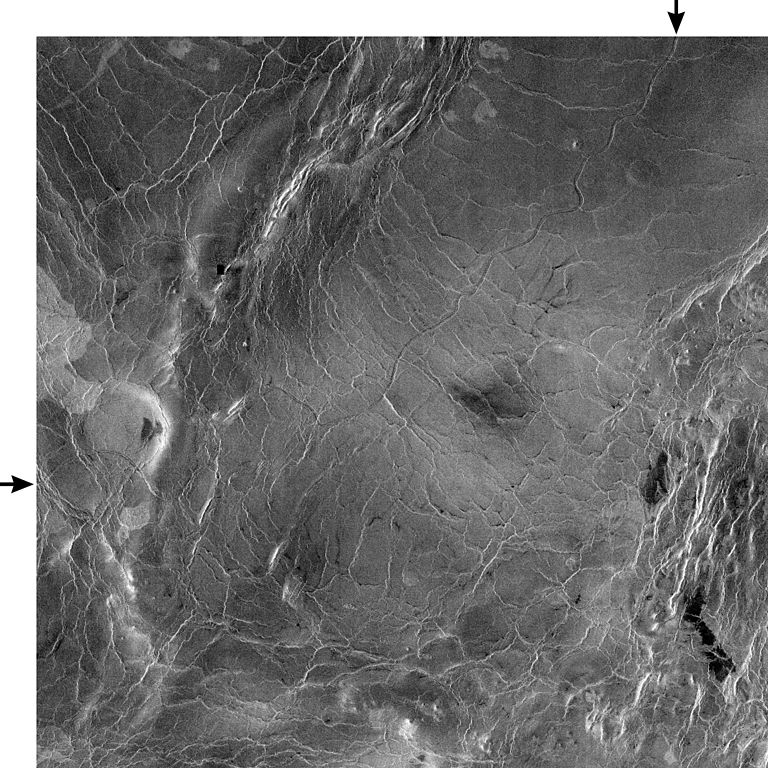
PIA00245: Venus - 600 Kilometer Segment of Longest Channel on Venus This compressed resolution radar mosaic from Magellan at 49 degrees north latitude, 165 degrees east longitude with dimensions of 460 by 460 kilometers (285 by 285 miles), shows a 600 kilometers (360 mile) segment of the longest channel discovered on Venus to date. The channel is approximately 1.8 kilometers (1.1 miles) wide. At more than 7,000 kilometers (4,200 miles) long, it is several hundred kilometers longer than the Nile River, Earth's longest river, thus making it the longest known channel in the solar system. Both ends of the channel are obscured, however, so its original length is unknown. The channel was initially discovered by the Soviet Venera 15-16 orbiters which, in spite of their one kilometer resolution, detected more than 1,000 kilometers (620 miles) of the channel. These channel-like features are common on the plains of Venus. In some places they appear to have been formed by lava which may have melted or thermally eroded a path over the plains' surface. Most are 1 to 3 kilometers (0.6 to 2 miles) wide. They resemble terrestrial meandering rivers in some aspects, with meanders, cutoff bows and abandoned channel segments. However, Venus channels are not as tightly sinuous as terrestrial rivers. Most are partly buried by younger lava plains, making their sources difficult to identify. A few have vast radar-dark plains units associated with them, suggesting large flow volumes. These channels, with large deposits appear to be older than other channel types, as they are crossed by fractures and wrinkle ridges, and are often buried by other volcanic materials. In addition, they appear to run both upslope and downslope, suggesting that the plains were warped by regional tectonism after channel formation. Resolution of the Magellan data is about 120 meters (400 feet). The white margins and arrows have been added to the NASA image. |
| Dátum | |
| Forrás | http://photojournal.jpl.nasa.gov/catalog/PIA00245 |
| Szerző | NASA/Jet Propulsion Lab |
Ezt a képet vagy videót az Amerikai Egyesült Államok Nemzeti Légügyi és Űrhajózási Hivatalának (NASA) Sugárhajtás Laboratóriumakategorizálta a következő azonosító kód alatt: fénykép-azonosító: PIA00245. Ez a sablon nem a licenc jelölésére szolgál. Szükség van egy licencsablonra is. Lásd a Commons:Licencelés lapot. Más nyelvek:
|
Licenc
| Ezt a fájlt a NASA készítette, ezért az Egyesült Államokban közkincsnek számít. A NASA szerzői jogi irányelve alapján „a NASA anyagai nem állnak szerzői jogi védelem alatt, kivéve, ha az külön jelezve van". (Lásd még: Sablon:PD-USGov, a NASA szerzői jogi- és a JPL képhasználati irányelve.) | ||
 |
Figyelmeztetések:
|
Fájltörténet
Kattints egy időpontra, hogy a fájl akkori állapotát láthasd.
| Dátum/idő | Bélyegkép | Felbontás | Feltöltő | Megjegyzés | |
|---|---|---|---|---|---|
| aktuális | 2007. december 8., 21:07 | | 2 150 × 2 150 (1,99 MB) | WolfmanSF | {{Information |Description=PIA00245: Venus - 600 Kilometer Segment of Longest Channel on Venus This compressed resolution radar mosaic from Magellan at 49 degrees north latitude, 165 degrees east longitude with dimensions of 460 by 460 kilometers (285 by |
Fájlhasználat
Az alábbi lap használja ezt a fájlt:
Globális fájlhasználat
A következő wikik használják ezt a fájlt:
- Használata itt: en.wikipedia.org
- Használata itt: fi.wikipedia.org
- Használata itt: fr.wikipedia.org
- Használata itt: gl.wikipedia.org
- Használata itt: it.wikipedia.org
- Használata itt: uk.wikipedia.org
- Használata itt: www.wikidata.org
- Használata itt: zh.wikipedia.org