
Fájl:Greenwich Village map circa 1760 - Project Gutenberg eText 16907.jpg

Eredeti fájl (1 000 × 1 151 képpont, fájlméret: 290 KB, MIME-típus: image/jpeg)
|
Ez a fájl a Wikimedia Commonsból származik. Az alább látható leírás az ottani dokumentációjának másolata. A Commons projekt szabad licencű kép- és multimédiatár. Segíts te is az építésében! |
Összefoglaló
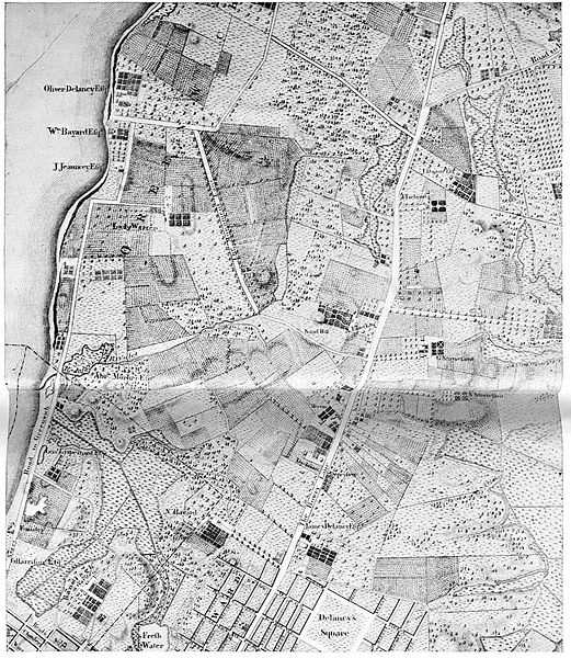
- Map of old Greenwich Village. A section of Bernard Ratzer's map of New York and its suburbs, made in the Eighteenth Century, when Greenwich was more than two miles from the city.
Bernard Ratzer's Greenwich Village map circa 1760 - Project Gutenberg eText 16907
From The Project Gutenberg EBook of Greenwich Village, by Anna Alice Chapin
- A glance at Bernard Ratzer's map—made in the beginning of the last half of the eighteenth century for the English governor, Sir Henry Moore—shows the only important holdings in the neighbourhood at that time: the Warren place, the Herrin (Haring or Harring) farm, the Eliot estate, etc. The site of the Square, in fact, was [Pg 9]originally composed of two separate tracts and had two sources of title, divided by Minetta Brook, which crossed the land about sixty feet west of where Fifth Avenue starts today. Westward lay that rather small portion of the land which belonged to the huge holdings of Sir Peter Warren, of whom more anon.
Sir Henry Moore, Baronet (1713-1769) was a British colonial leader who served as royal Governor of New York from 1765 to 1769. => map should be dated within this range
http://www.gutenberg.org/etext/16907
| Bernard Ratzer
(1700–) |
|||
|---|---|---|---|
| További nevei |
Bernard Ratzen | ||
| Leírás | brit kartográfus és surveyor | ||
| Születési dátum |
1700 | ||
| Munkássága időszaka | 1756–84 | ||
| Munkásságának helye |
New York region | ||
| Nemzetközi katalógus | |||
Licenc
| This image comes from the Project Gutenberg archives. This is an image that has come from a book or document for which the American copyright has expired and this image is in the public domain in the United States and possibly other countries.
This eBook is for the use of anyone anywhere at no cost and with almost no restrictions whatsoever. You may copy it, give it away or re-use it under the terms of the Project Gutenberg License included with this eBook or online at www.gutenberg.net. |
derivative works
Származékos művek: Greenwich Village map circa 1760 - Project Gutenberg eText 16907 cropped.jpg
Fájltörténet
Kattints egy időpontra, hogy a fájl akkori állapotát láthasd.
| Dátum/idő | Bélyegkép | Felbontás | Feltöltő | Megjegyzés | |
|---|---|---|---|---|---|
| aktuális | 2007. február 21., 12:57 | | 1 000 × 1 151 (290 KB) | Tagishsimon | == Summary == :'''Map of old Greenwich Village. A section of Bernard Ratzer's map of New York and its suburbs, made in the Eighteenth Century, when Greenwich was more than two miles from the city.''' Bernard Ratzer's Greenwich Village map circa 1760 |
Fájlhasználat
Az alábbi lap használja ezt a fájlt:
Globális fájlhasználat
A következő wikik használják ezt a fájlt:
- Használata itt: en.wikipedia.org
- Használata itt: es.wikipedia.org
- Használata itt: fr.wikipedia.org
- Használata itt: simple.wikipedia.org