
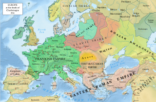
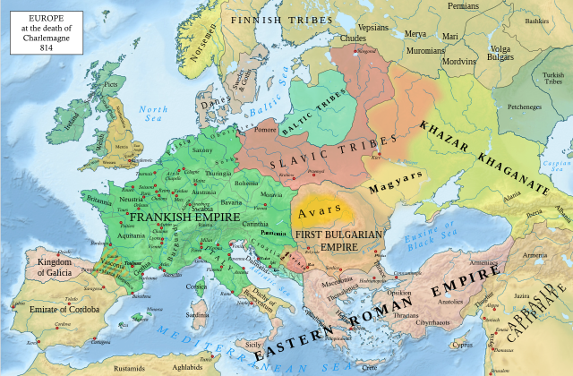
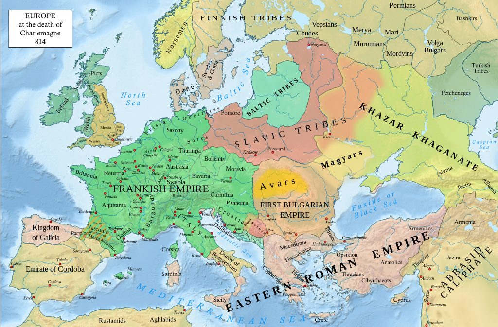
Fájl:Europe 814.svg

Eredeti fájl (SVG fájl, névlegesen 1 399 × 919 képpont, fájlméret: 3,4 MB)
|
Ez a fájl a Wikimedia Commonsból származik. Az alább látható leírás az ottani dokumentációjának másolata. A Commons projekt szabad licencű kép- és multimédiatár. Segíts te is az építésében! |
Összefoglaló
| Leírás |
English: An svg version of File:Europe 814.jpg with corrections.
List of corrections:
|
| Dátum | |
| Forrás | "The Public Schools Historical Atlas" by Charles Colbeck. Longmans, Green; New York; London; Bombay. 1905. |
| Szerző | Hel-hama |
| Más változatok |
|


_en.png)
.png)
.jpg)
Licenc
- A következőket teheted a művel:
- megoszthatod – szabadon másolhatod, terjesztheted, bemutathatod és előadhatod a művet
- feldolgozhatod – származékos műveket hozhatsz létre
- Az alábbi feltételekkel:
- Nevezd meg! – A szerzőt megfelelően fel kell tüntetned, hivatkozást kell létrehoznod a licencre és jelezned kell, ha a művön változtatást hajtottál végre. Ezt bármilyen észszerű módon megteheted, kivéve oly módon, ami azt sugallná hogy a jogosult támogat téged vagy a felhasználásod körülményeit.
- Így add tovább! – Ha megváltoztatod, átalakítod, feldolgozod ezt a művet, a közreműködésedet csak az eredetivel megegyező vagy hasonló licenc alatt terjesztheted.
Ez a fájl közkincsnek minősül az Amerikai Egyesült Államokban. Ez az olyan USA-ban készült művekre vonatkozik, amelyeknek lejárt a védelmi idejük, általában azért, mert 1929. január 1. előtt publikálták. Lásd ezt a lapot a további magyarázathoz.
|
 | |
 |
A kép nem biztos, hogy az Egyesült Államokon kívül is közkincsnek minősül; különösen olyan országokban nem, amelyek nem fogadták el a rövidebb védelmi idő szabályát (rule of the shorter term), például Kanada, Kína (Hongkong és Makaó kivételével), Németország, Mexikó és Svájc. A szerző neve és a közzététel éve nélkülözhetetlen adat, mindenképp meg kell adni. További információért lásd Wikipedia:Public domain és Wikipedia:Copyrights.
|
.svg)
|
This file is licensed under the Open Government Licence version 1.0 (OGL v1.0).
|
|---|---|
|
You are free to:
See the Open Government Licence page on Meta-Wiki for more information.
|
This work is in the public domain in India because its term of copyright has expired.
The Indian Copyright Act applies in India to works first published in India. According to the Indian Copyright Act, 1957, as amended up to Act No. 27 of 2012 (Chapter V, Section 25):
|
 |
Fájltörténet
Kattints egy időpontra, hogy a fájl akkori állapotát láthasd.
| Dátum/idő | Bélyegkép | Felbontás | Feltöltő | Megjegyzés | |
|---|---|---|---|---|---|
| aktuális | 2023. január 8., 22:05 | | 1 399 × 919 (3,4 MB) | Miki Filigranski | correction of Bosnian border, which was a separate land according to modern scholarship, contested but never completelly under Serbian or Croatian control |
| 2022. november 29., 23:32 |  | 1 399 × 919 (3,39 MB) | Gyalu22 | Added Avar ethnic territory, see Bulgarians_and_Slavs_VI-VII_century.png. Also extended Magyar ethnic territory to Bessarabia | |
| 2022. november 1., 12:26 |  | 1 399 × 919 (3,38 MB) | Miki Filigranski | Reverted to version as of 07:20, 31 July 2022 (UTC) | |
| 2022. augusztus 3., 06:47 |  | 1 399 × 919 (3,38 MB) | Bernd21t | (szerkesztési összefoglaló eltávolítva) | |
| 2022. július 31., 09:20 |  | 1 399 × 919 (3,38 MB) | Miki Filigranski | Reverted to version as of 16:51, 27 March 2022 (UTC) | |
| 2022. július 18., 07:13 |  | 1 399 × 919 (3,38 MB) | Ionelen | Reverted to version as of 19:41, 13 April 2022 (UTC) | |
| 2022. július 12., 09:41 |  | 1 399 × 919 (3,38 MB) | Ahmet Q. | Reverted to version as of 16:51, 27 March 2022 (UTC) | |
| 2022. április 13., 21:41 |  | 1 399 × 919 (3,38 MB) | Wojsław12 | Reverted to version as of 11:43, 14 January 2022 (UTC) | |
| 2022. március 27., 18:51 |  | 1 399 × 919 (3,38 MB) | Silverije | Reverted to version as of 12:43, 1 June 2021 (UTC) | |
| 2022. január 14., 13:43 |  | 1 399 × 919 (3,38 MB) | TómasdeAquino2 | Corrected POV issues of blocked sock of Crovata Miki Filigranski |
Fájlhasználat
Ezt a fájlt nem használja egyetlen lap sem.
Globális fájlhasználat
A következő wikik használják ezt a fájlt:
- Használata itt: af.wikipedia.org
- Használata itt: ar.wikipedia.org
- Használata itt: arz.wikipedia.org
- Használata itt: bg.wikipedia.org
- Használata itt: bn.wikipedia.org
- Használata itt: ca.wikipedia.org
- Használata itt: cs.wikipedia.org
- Használata itt: cy.wikipedia.org
- Használata itt: de.wikipedia.org
- Használata itt: el.wikipedia.org
- Használata itt: en.wikipedia.org
- Charlemagne
- History of Europe
- Vikings
- 814
- History of Estonia
- Bulgars
- Principality of Serbia (early medieval)
- Saare County
- Early Middle Ages
- Kvenland
- Askold and Dir
- Duchy of Benevento
- Portal:Estonia
- Franks
- Višeslav of Serbia
- History of Christian thought on persecution and tolerance
- Borna (duke)
- Vlastimir
- Arab–Khazar wars
- Duchy of Gascony
- Muslim conquest of Sicily
- Prosigoj
- Rus' people
- Early Slavs
- Radoslav of Serbia
- Barbarian kingdoms
- Agriculture in the Middle Ages
- Gersuinda
- User:Falcaorib
- Használata itt: en.wikibooks.org
A fájl globális használatának megtekintése