
Fájl:10May 16May Battle of Belgium.PNG

Az előnézet mérete: 775 × 599 képpont További felbontások: 311 × 240 képpont | 621 × 480 képpont | 891 × 689 képpont.
Eredeti fájl (891 × 689 képpont, fájlméret: 156 KB, MIME-típus: image/png)
|
Ez a fájl a Wikimedia Commonsból származik. Az alább látható leírás az ottani dokumentációjának másolata. A Commons projekt szabad licencű kép- és multimédiatár. Segíts te is az építésében! |
| Leírás |
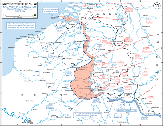
English: The German advance between 10 May and 16 May 1940. The red area denotes the territory captured by Germany during this time. The German field armies and Corps are shown in red. The red plan icon indicates the German airborne attack on the Belgian fortress of Eben-Emael. The operating area of the various Belgian, British, and French field armies and Army groups are shown in blue. The checkered white and blue area denotes the French Maginot Line. The commanders of the various units are shown under their respective formation. Solid lines represent the boundaries between each major unit. Dotted lines depict lines of advance. Key dates are shown in boxes. |
| Dátum | (UTC) |
| Forrás |
(Eredeti szöveg: „http://www.dean.usma.edu/history/web03/atlases/ww2%20europe/EuropeanTheaterGIF/WWIIEurope11.gif”) Archive link to original website used for the map and the archive link to the map source page. Current link to map, and link to map source page. |
| Szerző | The History Department of the United States Military Academy |
| Más változatok | File:10May-16May1940-Fall Gelb.jpg |
Licenc
Ezt a képet az Amerikai Egyesült Államok Szárazföldi Erőinek egy katonája vagy munkatársa készítette szolgálati ideje alatt. Az Egyesült Államok jogszabályai értelmében ez a kép közkincsnek minősül.
|
 |
Eredeti feltöltési napló
Áthozta Piotrus az en.wikipedia projektből a Commonsba CommonsHelper használatával.
Az eredeti leírólap itt volt. Az itt következő felhasználónevek az en.wikipedia projektre hivatkoznak.
- 2009-11-08 19:43 Coldplay Expert 891×689× (159258 bytes) {{Information |Description = The German advance until noon, 16 May 1940. The map also reveals the dispositions of the Belgian Army and its allies. |Source = http://www.dean.usma.edu/history/web03/atlases/ww2%20europe/EuropeanTheaterGIF/WWIIEu
Fájltörténet
Kattints egy időpontra, hogy a fájl akkori állapotát láthasd.
| Dátum/idő | Bélyegkép | Felbontás | Feltöltő | Megjegyzés | |
|---|---|---|---|---|---|
| aktuális | 2010. március 17., 20:35 | | 891 × 689 (156 KB) | File Upload Bot (Magnus Manske) | {{BotMoveToCommons|en.wikipedia|year={{subst:CURRENTYEAR}}|month={{subst:CURRENTMONTHNAME}}|day={{subst:CURRENTDAY}}}} {{Information |Description={{en|The German advance until noon, 16 May 1940. The map also reveals the dispositions of the Belgian Army a |
Fájlhasználat
Az alábbi lap használja ezt a fájlt:
Globális fájlhasználat
A következő wikik használják ezt a fájlt:
- Használata itt: azb.wikipedia.org
- Használata itt: ca.wikipedia.org
- Használata itt: en.wikipedia.org
- Battle of France
- 23rd (Northumbrian) Division
- French war planning 1920–1940
- British Expeditionary Force (World War II)
- 46th Infantry Division (United Kingdom)
- 12th (Eastern) Infantry Division
- Historiography of the Battle of France
- German radio intelligence operations during World War II
- Talk:World War II/Archive 53
- XIX Army Corps
- Használata itt: es.wikipedia.org
- Használata itt: fr.wikipedia.org
- Használata itt: ko.wikipedia.org
- Használata itt: ms.wikipedia.org
- Használata itt: nl.wikipedia.org
- Használata itt: pl.wikipedia.org
- Használata itt: ro.wikipedia.org
- Használata itt: sr.wikipedia.org
- Használata itt: ta.wikipedia.org
- Használata itt: th.wikipedia.org
- Használata itt: uk.wikipedia.org
- Használata itt: vi.wikipedia.org